
State Route 125 (SR 125) is a primary state highway in the U.S. state of Virginia. Known as Kings Highway, the state highway has two sections that run...
5 KB (352 words) - 02:39, 23 March 2022

State Route 80 is a primary state highway in the southwest part of the U.S. state of Virginia. It runs from the Kentucky state line at Breaks Interstate...
12 KB (985 words) - 04:09, 6 February 2024

State Route 125 (SR 125) is a state highway in the U.S. state of California that serves as a north–south route in the San Diego area. It runs from SR 11...
61 KB (7,721 words) - 00:39, 5 August 2024
125 Quebec Route 125 National Route 125 National Highway 125 (Uttarakhand) State road 125 Japan National Route 125 Mexican Federal Highway 125 A125 highway...
5 KB (331 words) - 15:15, 9 April 2024
Virginia state institutions, see State highways serving Virginia state institutions. State Route 34 is the designation for Hodges Street, which runs 0.54...
55 KB (3,051 words) - 17:28, 25 July 2024

State Route 32 (SR 32) is a primary state highway in the U.S. state of Virginia. The state highway runs 38.89 miles (62.59 km) from the North Carolina...
10 KB (755 words) - 23:59, 11 June 2024

former primary state highways completely or mostly within the Bristol District (VDOT District 1) of the U.S. state of Virginia. State Route 62 extended south...
29 KB (4,335 words) - 19:47, 11 January 2023
King's Highway (redirect from Kings highway (Virginia))
Highway (Virginia State Route 3), central Virginia Kings Highway (Virginia State Route 125), Suffolk, Virginia Kings Highway (New Jersey Route 27), northern...
3 KB (363 words) - 06:35, 30 March 2024

closely parallels Virginia's southern border with North Carolina. State Route 383 (SR 383) is overlaid on U.S. Route 58 in Tennessee. U.S. Route 58 is the longest...
47 KB (1,992 words) - 01:35, 21 April 2024

State Route 10 (SR 10) is a primary state highway in the U.S. state of Virginia. The state highway runs 93.58 miles (150.60 km) from U.S. Route 360 (US...
23 KB (1,570 words) - 05:27, 30 January 2024
State Route 88 was a primary state highway in the U.S. state of Virginia. The number was assigned in the 1940 renumbering to replace part of State Route...
42 KB (5,836 words) - 16:39, 4 March 2022

Virginia State Route 3 is a primary state highway in the U.S. state of Virginia that extends from the town of Culpeper south and eastwardly to Gloucester...
31 KB (2,726 words) - 15:19, 30 April 2024

Illinois Route 125 (IL-125) is a major 37.10 miles (59.71 km) highway in the central portion of the U.S. state of Illinois. Illinois 125 runs east from...
4 KB (310 words) - 03:14, 10 January 2024
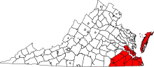
in Jacksonville, North Carolina north to Virginia State Route 143 (SR 143) at Fort Monroe in Hampton, Virginia. In North Carolina, US 258 connects Jacksonville...
42 KB (2,964 words) - 10:03, 15 March 2024

Route 17 (US 17) is a part of the United States Numbered Highway System that runs from Punta Gorda, Florida, to Winchester, Virginia. In Virginia, the...
44 KB (2,498 words) - 22:33, 25 January 2024

South Carolina, to Wytheville, Virginia. The route traverses three states, South Carolina, North Carolina, and Virginia. It connects southeastern cities...
44 KB (1,789 words) - 22:58, 6 June 2024

State Route 65 (SR 65), formerly State Route 66 (SR 66), is a primary state highway in the U.S. state of Virginia. The state highway runs 34.06 miles (54...
6 KB (380 words) - 06:21, 30 January 2024

Virginia, United States. The population was 125 at the 2020 census. It is the county seat of Craig County. The junctions of State Route 311 and State...
8 KB (650 words) - 10:08, 16 June 2024

Virginia, officially the Commonwealth of Virginia, is a state in the Southeastern and Mid-Atlantic regions of the United States between the Atlantic Coast...
299 KB (26,603 words) - 20:24, 11 August 2024
following is a partial list of former primary state highways in the U.S. state of Virginia. Long-distance routes are listed here, while those entirely or mostly...
15 KB (1,209 words) - 15:08, 7 August 2024

U.S. Route 29 (US 29) is a major north–south route in the commonwealth of Virginia. It covers 248.0 miles (399.1 km) from the North Carolina border at...
50 KB (2,505 words) - 13:35, 3 August 2024

State Route 126 (SR 126) is a primary state highway in the U.S. state of Virginia. Known as Fairgrounds Road, the state highway runs 1.38 miles (2.22 km)...
4 KB (208 words) - 05:57, 9 February 2024
primary state highways in Virginia shorter than one mile List of primary state highways serving Virginia state institutions "Virginia Route Index" (PDF)...
118 KB (149 words) - 15:21, 7 August 2024

State Route 293 (SR 293) is a primary state highway in the U.S. state of Virginia. The state highway runs 7.05 miles (11.35 km) between intersections with...
6 KB (479 words) - 00:19, 2 May 2024

State Route 337 (SR 337) is a primary state highway in the South Hampton Roads area of the U.S. state of Virginia. It runs east from Suffolk to Portsmouth...
27 KB (2,227 words) - 14:58, 7 January 2024

State Route 51 (SR 51) is a primary state highway in the U.S. state of Virginia. Known as Westover Drive, the state highway runs 6.20 miles (9.98 km)...
4 KB (251 words) - 06:17, 30 January 2024

Virginia State Route 13 State Route 341, Centerville west to Parksley, now SR 176 State Route 342, Tasley west to Onancock, now SR 126 State Route 343...
41 KB (3,694 words) - 15:42, 4 May 2024

U.S. Route 460 (US 460) in Virginia runs west-east through the southern part of the Commonwealth. The road has two separate pieces in Virginia, joined...
82 KB (6,756 words) - 21:28, 15 April 2024

The state highway system of the U.S. state of Virginia is a network of roads maintained by the Virginia Department of Transportation (VDOT). As of 2006...
17 KB (1,842 words) - 23:43, 9 February 2023