
The Wellhorn is a mountain of the Bernese Alps, overlooking Rosenlaui in the Bernese Oberland. On its eastern side is the Rosenlaui Glacier. Retrieved...
1 KB (57 words) - 06:06, 1 May 2024
The Klein Wellhorn (also spelled Kleines Wellhorn) is a mountain in the Bernese Alps, overlooking Rosenlaui in the Bernese Oberland. It lies north of...
1 KB (51 words) - 16:08, 15 May 2022

The village is surrounded by the mountains of the Faulhorn, Schwarzhorn, Wellhorn, Wetterhorn, Mettenberg, Schreckhorn, Lauteraarhorn, Agassizhorn, Fiescherhorn...
37 KB (4,052 words) - 13:05, 19 August 2024
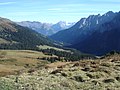
the valley rise the Wetterhorn (3,692 m), the Engelhörner (2,782 m), the Wellhorn (3,191 m), besides the Rosenlaui Glacier. Also east of the valley is the...
3 KB (257 words) - 06:32, 7 May 2024

Petersgrat 3,202 m (10,505 ft) Strahlhorn (Baltschieder) 3,201 m (10,502 ft) Wellhorn 3,191 m (10,469 ft) Firehorn 3,182 m (10,440 ft) Steinlauihorn 3,161 m...
24 KB (1,279 words) - 07:52, 22 May 2024

Wellhorn and the Rosenlaui Glacier, photographed by Braun circa 1860...
10 KB (1,051 words) - 21:18, 9 January 2024

Dossen Dossen (left) and Wellhorn (right) Highest point Elevation 3,144 m (10,315 ft) Prominence 109 m (358 ft) Parent peak Finsteraarhorn Coordinates...
2 KB (107 words) - 13:34, 1 May 2024

Alps and reaches an elevation of 3,191 m (10,469 ft) at the summit of the Wellhorn. It includes the village of Meiringen and the settlements of Sand, Stein...
33 KB (3,480 words) - 08:59, 20 August 2024

/ 46.23694°N 8.05528°E / 46.23694; 8.05528 Lepontine Alps Valais 242 Wellhorn 3191 240 46°39′21″N 08°08′31″E / 46.65583°N 8.14194°E / 46.65583; 8...
55 KB (359 words) - 18:05, 9 July 2024
51861°N 7.82000°E / 46.51861; 7.82000 Bernese Alps Interlaken-Oberhasli Wellhorn 3191 240 46°39′21″N 08°08′31″E / 46.65583°N 8.14194°E / 46.65583; 8...
27 KB (312 words) - 06:35, 6 May 2024

at an elevation of about 850 m (2,790 ft). The highest mountain is the Wellhorn, on the southwestern edge of the municipality (3,192 m [10,472 ft]). Part...
22 KB (2,427 words) - 23:15, 22 March 2024