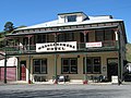
Whangamōmona is a small township in the Stratford District and Manawatū-Whanganui Region in New Zealand. It lies on State Highway 43, the "Forgotten World...
12 KB (1,142 words) - 09:24, 12 July 2024

The Whangamōmona River is a river of the Manawatū-Whanganui region of New Zealand's North Island. It flows generally southeast from its sources near Whangamōmona...
4 KB (103 words) - 22:28, 12 July 2024

climbs three saddles: the Strathmore Saddle, Whangamōmona Saddle, and Tahora Saddle. 14 km past Whangamōmona is the Moki Tunnel, also known as Hobbit's...
5 KB (484 words) - 09:02, 11 September 2023
winter, green in spring, yellow in summer, and red in autumn. Seal of Whangamōmona. The principality adopted all four of these flags. Ryan, John; Dunford...
78 KB (2,539 words) - 16:01, 17 August 2024
Wellsford* Weston Westport* Whakamaru Whakatāne* Whananaki Whangamatā* Whangamōmona Whanganui* Whangaparāoa* Whangārei* Whangārei Heads Whangaruru Whangateau...
15 KB (942 words) - 19:15, 12 August 2024

between the Manawatū-Whanganui region (including the settlements of Whangamōmona, Marco and Tahora, 31.87% of its land area) and the Taranaki region (68...
24 KB (2,314 words) - 15:44, 12 August 2024

with an emphasis on catchments being connected. These revised maps made Whangamōmona part of the Manawatū-Whanganui Region. Residents wanted to continue to...
36 KB (3,465 words) - 19:52, 3 August 2024

into it in 1922) Ohura Taumarunui Taupo Cook Wairoa Taranaki Clifton Whangamomona Inglewood Kaitieke Egmont Stratford Waimarino Hawkes Bay Eltham Waimate...
8 KB (446 words) - 08:35, 12 August 2024

re-opening the Stratford to Okahukura line. The line from Stratford to Whangamōmona (of about 48 miles or 77 km) was authorised by the Railways Authorisation...
22 KB (2,108 words) - 08:33, 17 August 2024
Wanganui County; and towards the west generally by Waitotara County and Whangamomona County: excluding the Ohakune Town District. Waimarino County was amalgamated...
2 KB (149 words) - 08:02, 13 April 2024

the Retaruke River. Coal was discovered in 1909 in the Late Miocene Whangamomona Group. During the 1960s and 1970s, an opencast coal mine operated at...
14 KB (1,014 words) - 23:36, 12 July 2024

River Marlborough Minerva Murrawarri Republic Rainbow Creek Snake Hill Whangamōmona Wy Sovereign Yidindji Government Extraterrestrial Aerican Empire Asgardia...
79 KB (8,052 words) - 00:07, 17 August 2024
located within Stratford itself, while the others are located in Ngaere, Whangamōmona, and Douglas. Heritage New Zealand Pouhere Taonga Act 2014 (s. 65). New...
6 KB (250 words) - 21:54, 6 June 2024

WKP 089 39 Whakatane WHK 076 Whangaaehu WGU 064 26 Whangamata WGM 0816 Whangamomona WMM 0663 25 Whangara WGH 079 22 Whangarei WR 089 Whangarei Heads WRH...
34 KB (1,745 words) - 10:36, 30 July 2024

River Marlborough Minerva Murrawarri Republic Rainbow Creek Snake Hill Whangamōmona Wy Sovereign Yidindji Government Extraterrestrial Aerican Empire Asgardia...
8 KB (748 words) - 14:55, 21 May 2024

River Marlborough Minerva Murrawarri Republic Rainbow Creek Snake Hill Whangamōmona Wy Sovereign Yidindji Government Extraterrestrial Aerican Empire Asgardia...
4 KB (334 words) - 13:11, 13 July 2024

River Marlborough Minerva Murrawarri Republic Rainbow Creek Snake Hill Whangamōmona Wy Sovereign Yidindji Government Extraterrestrial Aerican Empire Asgardia...
15 KB (1,656 words) - 21:10, 9 June 2024

River Marlborough Minerva Murrawarri Republic Rainbow Creek Snake Hill Whangamōmona Wy Sovereign Yidindji Government Extraterrestrial Aerican Empire Asgardia...
3 KB (184 words) - 15:09, 2 June 2024
network (excluding off-ramps and on-ramps) are on SH 43 north-east of Whangamōmona, with fewer than 120 vehicles (counting both directions) in a day. The...
23 KB (2,353 words) - 20:54, 1 August 2024
between the Manawatū-Whanganui region (including the settlements of Whangamōmona, Marco and Tahora, 31.87% of its land area) and the Taranaki region (68...
20 KB (2,047 words) - 04:21, 2 June 2024
the safe Labour seat of New Lynn, in West Auckland, despite being from Whangamōmona, a small town in the Manawatū-Whanganui region. She beat out Greg Presland...
61 KB (6,119 words) - 11:14, 12 August 2024
of New Zealand. It is located to the northeast of Whangamōmona on State Highway 43. The Whangamōmona River flows through the area. The Stratford - Okahukura...
3 KB (258 words) - 01:22, 23 June 2022
Otakeho Cemetery, Tahora Cemetery, Te Namu Maori Cemetery, Waihi Cemetery, Whangamomona Cemetery, n.p.: n.p., n.d. There is a series of interviews conducted...
3 KB (245 words) - 00:32, 3 November 2022
Taringamotu River Ohura River Taumona River Retaruke River Tāngarākau River Whangamōmona River Manganui o te Ao River Makatote River Mangaturuturu River Whangaehu...
2 KB (151 words) - 00:35, 14 April 2024
Ngakawau 136 km (85 mi) Freight only Stratford–Okahukura Line Stratford – Whangamōmona – Okahukura 144 km (89 mi) Passenger: leased to a private operator June...
34 KB (1,572 words) - 12:00, 3 August 2024

• left Whakapapa River, Retaruke River, Manganui o te Ao River • right Pungapunga River, Ongarue River, Ohura River, Tangarakau River, Whangamōmona River...
31 KB (2,753 words) - 08:07, 14 July 2024

Christchurch, 1900 m long. Opened 1964. Moki Tunnel – on SH 43 between Whangamōmona and Taumarunui, approx 200 m long. Single lane, uses wooden shoring....
20 KB (2,482 words) - 07:26, 29 July 2024
Whangaehu River Whangamarino River Whangamaroro River Whangamoa River Whangamōmona River Whanganui River Whangaparāoa River Whareama River Whareatea River...
31 KB (2,843 words) - 05:08, 4 May 2024
River Marlborough Minerva Murrawarri Republic Rainbow Creek Snake Hill Whangamōmona Wy Sovereign Yidindji Government Extraterrestrial Aerican Empire Asgardia...
6 KB (674 words) - 23:16, 17 August 2024
Westland 1876 1989 11000 km2 Hokitika Whakatane 1876 km2 Whakatane Whangamomona km2 Whangarei 1876 1989 2681.8 km2 Kamo Part merged into Kaipara District...
84 KB (2,488 words) - 08:38, 12 August 2024