
Yamanto is a suburb of Ipswich in the City of Ipswich, Queensland, Australia. In the 2021 census, Yamanto had a population of 4,971 people. The origin...
5 KB (477 words) - 13:08, 17 July 2024

north (Amberley / Yamanto) where it becomes a tributary of Warrill Creek. The Cunningham Highway enters the locality from the north (Yamanto / Deebing Heights)...
11 KB (954 words) - 17:57, 25 July 2024
Ipswich and Rosewood railway line (redirect from Ipswich railway line, Queensland)
line has been proposed on an alignment extending south from Ipswich to Yamanto, then east to Ripley, and connecting with the Springfield line. Most services...
9 KB (829 words) - 03:28, 28 April 2024
1 January 2010, the school was again relocated to Deebing Creek Road, Yamanto and renamed Amberley District State School. In December 1867 a United Methodist...
11 KB (773 words) - 05:14, 10 July 2024

Churchill is a suburb of Ipswich in the City of Ipswich, Queensland, Australia. In the 2021 census, Churchill had a population of 1,842 people. The western...
9 KB (782 words) - 06:15, 10 July 2024

Raceview to the north and Amberley District State School in neighbouring Yamanto to the west. The nearest government secondary school is Bremer State High...
4 KB (293 words) - 06:23, 10 July 2024

City of Ipswich (redirect from City of Ipswich, Queensland)
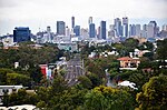
in turn, is situated within the vast South East region of the state of Queensland. Positioned between the City of Brisbane and the City of Logan to the...
35 KB (1,711 words) - 10:39, 11 September 2024
Cunningham Highway state-controlled roads (category Roads in Queensland)
to the Cunningham Highway in Yamanto, a distance of 14.5 kilometres (9.0 mi). It intersects with River Road (Queensland) in Dinmore and Ipswich–Warrego...
22 KB (1,702 words) - 22:38, 9 February 2024

Mile 509: Yamanto to Riverlink Shopping Centre 512: Brassall to Riverlink Shopping Centre 514: Moores Pocket to Booval 515: Brassall to Yamanto & Willowbank...
13 KB (770 words) - 05:09, 9 July 2023

Churchill is a county (a cadastral division) in Queensland, Australia. Like all counties in Queensland, it is a non-functional administrative unit, that...
8 KB (179 words) - 06:29, 22 August 2019

community. Ripley is serviced by bus route 531 between Springfield Central and Yamanto. Planned transportation links includes an extension of the Springfield...
14 KB (1,152 words) - 08:17, 30 August 2024

Central – Springfield Lakes – Tivoli – West Ipswich – Woodend – Wulkuraka – Yamanto Total: 49 Amberley – Ashwell – Calvert – Deebing Heights – Ebenezer – Goolman...
35 KB (1,261 words) - 02:04, 12 May 2024

One Mile is a suburb of Ipswich in the City of Ipswich, Queensland, Australia. In the 2021 census, One Mile had a population of 2,038 people. One Mile...
12 KB (950 words) - 06:35, 10 July 2024

nearest government primary schools are Amberley District State School in Yamanto to the north-east and Mutdapilly State School in Mutdapilly to the south...
10 KB (802 words) - 04:04, 31 May 2024
Road routes in Queensland assist drivers navigating roads throughout the state, by identifying important through-routes. Queensland is in the process of...
81 KB (600 words) - 20:26, 24 January 2024
Ipswich–Boonah–Rathdowney Road (category Roads in Queensland)
in Queensland "Yamanto to Rathdowney" (Map). Google Maps. Retrieved 3 October 2021. The State Road Network of Queensland (PDF) (Map). Queensland Government...
10 KB (725 words) - 17:16, 25 July 2024

Centenary Motorway (category Highways in Queensland)
suburbs of Brisbane, Australia. It starts as a two-lane arterial road at Yamanto, travelling to Springfield, where it becomes a two-lane highway and travels...
9 KB (519 words) - 10:37, 27 July 2023

Springfield railway line (category Ipswich, Queensland)
present terminus at Springfield Central to Redbank Plains, Ripley Valley, Yamanto, and Ipswich station. Passengers would change for or from the Ipswich and...
14 KB (954 words) - 03:30, 11 January 2024
Citipointe Church (category Churches in Queensland)
(Durack) and Citipointe Redcliffe (Clontarf), Citipointe Ipswich (located in Yamanto). Citipointe Pine Rivers was added in September 2016. The "Citipointe Campus"...
9 KB (966 words) - 20:53, 17 April 2023

Western Transport Corridor was planned to be built from Springfield to Yamanto via White Rock, Ripley and Deebing Heights. In 2009, construction was completed...
10 KB (1,085 words) - 06:19, 10 July 2024
neighbouring Walloon to the north, and Amberley District State School in Yamanto to the east. The nearest government secondary schools are Rosewood State...
9 KB (699 words) - 22:17, 27 May 2024

Cunningham Highway (category Highways in Queensland)
is a 327-kilometre (203 mi) national highway located in south-eastern Queensland, Australia. The highway links the Darling Downs region with the urbanised...
20 KB (1,363 words) - 22:27, 27 January 2024
Freeways in Australia (section Queensland)
Tunnel (Clem7) ( Electronically Tolled) Cunningham Highway (Riverview to Yamanto) 'No shield' Southern Cross Way Inner City Bypass (Lutwyche Road to Kingsford...
31 KB (2,595 words) - 02:13, 16 September 2024
International, Toowoomba, Queensland, Australia 7 Win 4–3 Rhys Sullivan KO 1 (4) 0:36 29 November 2014 Grand Hotel Yamanto, Ipswich, Queensland, Australia 6 Win...
12 KB (280 words) - 20:01, 21 August 2022
Numbered roads in Queensland provides readers with basic information about the many state-controlled roads in the state, particularly those for which there...
39 KB (404 words) - 11:15, 8 May 2024
Shire of Moreton (category Former local government areas of Queensland)
including: Rosevale, Munbilla, Warrill View, Harrisville, Peak Crossing, Yamanto, Loamside, Flinders View, Ripley and Willowbank. No. 4 Division covered...
10 KB (1,036 words) - 23:06, 2 September 2024
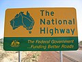
the Australian Capital Territory, New South Wales, and parts of both Queensland and Victoria. National Highway numbering originates from the earlier national...
37 KB (2,682 words) - 13:52, 5 September 2024

Springfield Central to Redbank Station 531: Orion Springfield Central to Yamanto via Ripley 534: Orion Springfield Central to Browns Plains 5240: Old Logan...
17 KB (1,180 words) - 03:10, 3 April 2024

Henry Challinor (category Members of the Queensland Legislative Assembly)
later giving its name to the Ipswich suburb of Yamanto. As a result of the reorganisation of Queensland mental health services in 1968, the Ipswich Mental...
19 KB (1,845 words) - 19:24, 19 January 2024

applied. Brisbane is a car dependent city. In 2006, within the South East Queensland region, 83% of trips were done by car. Brisbane is linked with both the...
15 KB (1,208 words) - 07:57, 17 March 2024