
Ediciones Nueva Guía, SA de CV. p. 59. ISBN 968-5437-26-2. "Resumen municipal Municipio de Calimaya" [Summary of the Municipality of Calimaya] (in Spanish). Mexico:...
29 KB (3,290 words) - 20:33, 22 August 2023

State of Mexico (redirect from Estado de Mexico)
is located fourteen km from the city of Toluca in the municipality of Calimaya. It is one of the few zoos in Mexico where all the animals live in natural-like...
77 KB (7,771 words) - 01:46, 3 September 2024

Spanish Conquest, Gonzálo de Sandoval and his Otomi allies, conquered Toluca, Tenango, Tlacotepec, Tecaxic-Calixtlahuaca, Calimaya along with Metepec and...
12 KB (1,144 words) - 06:00, 15 August 2024

extends 84.37 km2 and borders with the municipalities of Tenango del Valle, Calimaya and Almoloya del Río. The Lerma-Tenango Highway, is a main highway that...
7 KB (143 words) - 09:12, 26 January 2021
municipality is 12.20 square km and borders the municipalities of Metepec, Calimaya and Chapultepec. The total municipal population as of 2005 was 10,161 people...
8 KB (678 words) - 11:51, 3 July 2023

municipalities (see below). It is largely rural. Almoloya de Juárez Almoloya del Río Calimaya Chapultepec Metepec Mexicaltzingo Rayón San Antonio la Isla...
954 bytes (74 words) - 17:30, 11 September 2021
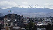
Toluca (redirect from Toluca de Lerdo)
the municipalities of Almoloya de Juárez, Temoaya, Otzolotepec, Xonacatlán, Lerma, San Mateo Atenco, Metepec, Calimaya, Tenango del Valle, Villa Guerrero...
62 KB (6,990 words) - 23:02, 26 August 2024
dependency of Calimaya. However, after petition, it was granted municipal status by degree in 1847. "Enciclopedia de los Municipios de Mexico Estado de Mexico...
6 KB (269 words) - 08:45, 6 March 2024
Mexicaltzingo, Calimaya and Tianguistenco. In 2010, the municipality had a total population of 12,120. "Chapultepec". Enciclopedia de los Municipios de México...
6 KB (106 words) - 16:26, 8 April 2021
corregidor of the State and Marquisate of Toluca with headquarters in Calimaya, granting him the lands of the Toluca valley, from Atizapán to Toluca,...
15 KB (1,628 words) - 16:59, 31 August 2024

Tenango del Valle (redirect from Tenango de Arista)
208.88 square kilometres (80.65 sq mi). It borders the municipalities of Calimaya, Santa María Rayón, Texcalyacac, Tenancingo, Villa Guerrero, and Toluca...
18 KB (1,862 words) - 03:56, 28 September 2021
Villa Guerrero, State of Mexico (section Central de Abasto de Villa Guerrero (Supply Center of Villa Guerrero))
Zinacantepec, Toluca, Calimaya and Tenango del Valle; to the east by the municipalities of Tenancingo and Zumpahuacán, to the south by Ixtapan de la Sal and to...
21 KB (2,815 words) - 22:14, 7 July 2024

Texcalyacac, Almoloya del Río, Santa Cruz Atizapan, San Antonio la Isla, Calimaya, Chapultepec and Mexicaltzingo with the Federal District to the east and...
27 KB (3,157 words) - 04:21, 15 August 2024
Santiago de Calimaya. The west part of the valley became part of the encomendero of Juan de Sámano. This same family founded the Hacienda de la Gavia...
27 KB (2,905 words) - 04:47, 12 January 2024

Nacional de Información Municipal" (in Spanish). SEGOB. 2010. Retrieved 4 November 2017. "San José del Rincón". Enciclopedia de los Municipios y Delegaciones...
10 KB (676 words) - 22:40, 30 August 2022