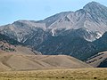
The 1983 Borah Peak earthquake occurred on October 28, at 8:06:09 a.m. MDT in the western United States, in the Lost River Range at Borah Peak in central...
15 KB (1,227 words) - 06:41, 17 February 2025

office in 1940. The 1983 Borah Peak earthquake occurred on Friday, October 28, at 8:06:09 MDT in the Lost River Range at Borah Peak in central Idaho, United...
11 KB (829 words) - 22:32, 4 January 2025
well-documented case of liquefaction in gravelly sands was in regard to the 1983 Borah Peak earthquake in the United States. Several investigations of that event took...
52 KB (6,064 words) - 15:12, 2 March 2025
November 2013). "Earthquakes in the Early Modern Era". Seismic Japan: The Long History and Continuing Legacy of the Ansei Edo Earthquake. University of...
12 KB (1,146 words) - 09:35, 2 February 2025
Surface rupture (redirect from Surface rupture earthquake)
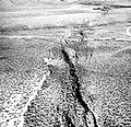
ground displacement) is the visible offset of the ground surface when an earthquake rupture along a fault affects the Earth's surface. Surface rupture is...
10 KB (904 words) - 18:39, 2 January 2025
occurred. Earthquake swarms which affected the United States: 1962–71 Denver earthquake swarm Enola earthquake swarm 2008 Reno earthquakes Guy-Greenbrier...
42 KB (1,726 words) - 17:03, 10 December 2024

Register of Historic Places in 1980. It was destroyed by the 1983 Borah Peak earthquake. It was a stone building, built of local tuff stone, which demonstrated...
2 KB (155 words) - 04:31, 4 August 2023

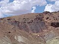
areas. Aerial photographs were also taken immediately after the 1983 Borah Peak earthquake near Challis. The Challis-Mackay region experienced rather thorough...
16 KB (2,018 words) - 19:52, 2 September 2024
other. Pink Geyser is susceptible to seismic activity. Before the 1983 Borah Peak earthquake, it only erupted twice a day. Following the quake, its interval...
3 KB (250 words) - 06:18, 5 September 2021

Challis, Idaho (section 1983 earthquake)
with Highway 75 is south of Challis. On Friday, October 28, 1983, the Borah Peak earthquake occurred at 8:06 am MDT. The shock measured 6.9 on the moment...
19 KB (1,525 words) - 12:27, 11 March 2025
Retrieved 3 August 2021. "M 6.9 – The 1983 Borah Peak Earthquake, Idaho". United States Geological Survey. 28 October 1983. Retrieved 3 August 2021. "M 6.8...
46 KB (1,686 words) - 23:16, 9 December 2024

Cold Storage, located at about 300 Main Ave., collapsed in the 1983 Borah Peak earthquake. In October 2017, Google Maps' Streetview photography dated June...
2 KB (222 words) - 14:36, 4 April 2024

residents fondly call "The Res". Mackay Reservoir survived the 1983 Borah Peak earthquake, despite extensive damage to the nearby towns of Mackay and Challis...
7 KB (608 words) - 11:29, 19 September 2023
list compiles known earthquakes that have caused one or more fatalities since 1900. The list incorporates high-quality earthquake source (i.e., origin...
218 KB (1,143 words) - 18:40, 14 February 2025
in 1980. The building collapsed, killing two children, in the 1983 Borah Peak earthquake. It was a one-story building with a stepped parapet facade, with...
2 KB (138 words) - 04:01, 6 August 2023

areas. Aerial photographs were also taken immediately after the 1983 Borah Peak earthquake near Challis. The Challis-Mackay region experienced rather thorough...
23 KB (2,472 words) - 04:18, 28 April 2024

Mackay, Idaho (section 1983 earthquake)
and 19.8% of those age 65 or over. On Friday, October 28, 1983, the Borah Peak earthquake occurred at 8:06 am MDT, measured at 6.9 on the moment magnitude...
15 KB (1,083 words) - 12:27, 11 March 2025

Lost River Range (section Peaks)
explaining the effects of the magnitude 6.9 Borah Peak earthquake that hit the range on October 28, 1983. The Big Lost River Valley fell and the Lost...
5 KB (390 words) - 14:46, 30 July 2024

of its next eruption.[citation needed] After the Borah Peak earthquake in central Idaho in October 1983, the eruption intervals of Old Faithful were noticeably...
12 KB (1,089 words) - 07:30, 9 March 2025
As its name indicates, Box Spring was a hot spring until the 1983 Borah Peak earthquake triggered activity in the spring and it began erupting. It was...
2 KB (160 words) - 08:59, 19 August 2022
The M7.3 1959 Hebgen Lake earthquake in Montana had a significant sequence of aftershocks, and the shallow M7 1983 Borah Peak event was followed by four...
15 KB (1,739 words) - 00:57, 23 January 2025
Borah Peak earthquake (October 28, 1983), which was followed by five other M 5+ events over the following year, and most recently a M5.0 earthquake in...
13 KB (1,075 words) - 14:20, 3 March 2025

This list of 20th-century earthquakes is a list of earthquakes of magnitude 6 and above that occurred in the 20th century. Sone smaller events which nevertheless...
141 KB (3,082 words) - 21:03, 15 January 2025

Idaho's highest point is Borah Peak, 12,662 ft (3,859 m), in the Lost River Range north of Mackay. In 1983, an earthquake there caused two fatalities...
35 KB (1,734 words) - 17:22, 3 September 2024
in 1881 for Idaho governor George L. Shoup, collapsed in the 1983 Borah Peak earthquake, killing two children 10 Challis High School More images December...
15 KB (316 words) - 05:47, 4 March 2025

Stanley, Idaho (section 2020 earthquake)
6.5 earthquake 20 miles northwest of Stanley shook the town. This was the second strongest earthquake recorded in Idaho, behind the 6.9 Borah Peak earthquake...
24 KB (1,620 words) - 12:27, 11 March 2025

susceptible to failure in case of an earthquake of magnitude 5.5 or greater. Following the Borah Peak earthquake of 1983 in Idaho, the dam was upgraded during...
11 KB (1,036 words) - 16:01, 19 August 2024
States. Microsoft Word is first released. October 28 – The 6.9 Mw Borah Peak earthquake shook central Idaho with a maximum Mercalli intensity of IX (Violent)...
80 KB (6,665 words) - 10:30, 3 March 2025

Service and the Bureau of Land Management. Idaho's tallest mountain, Borah Peak, is located in this region. A large part of the Sawtooth National Recreation...
15 KB (1,378 words) - 18:33, 14 February 2025
notable fault, but only major fault zones.[clarification needed] Lists of earthquakes Tectonics Yeats, R. (2012), Active Faults of the World, Cambridge University...
25 KB (221 words) - 21:29, 9 December 2024