The Advisory Committee on Antarctic Names (ACAN or US-ACAN) is an advisory committee of the United States Board on Geographic Names responsible for recommending...
27 KB (3,523 words) - 02:01, 27 October 2024
the Special Committee on Antarctic Names (SCAN). In 1963, the Advisory Committee on Undersea Features was started for standardization of names of undersea...
13 KB (1,328 words) - 03:01, 15 August 2024
Bunger Hills (category Infobox mapframe without OSM relation ID on Wikidata)
States Navy Operation Highjump (1946-1947) and named by the United States Advisory Committee on Antarctic Names (US-ACAN) for Lieutenant Commander David E...
7 KB (861 words) - 14:05, 29 February 2024
Thurston Island just east of Cape Petersen. Named by the United States Advisory Committee on Antarctic Names (US-ACAN) after Kevin M. Foley, United States...
16 KB (2,958 words) - 12:12, 19 April 2024
Carlstrom Foothills (category Coordinates on Wikidata)
the north and Flynn Glacier to the south. It was named by the Advisory Committee on Antarctic Names after John Carlstrom of the department of astronomy...
12 KB (1,488 words) - 15:57, 1 January 2024
Mount Takahe (category Coordinates on Wikidata)
surveys and U.S. Navy air photos (1959–1966) and was named by the Advisory Committee on Antarctic Names (US-ACAN) for Allan Gill, aurora researcher at Byrd...
53 KB (5,474 words) - 11:08, 3 November 2024
Vinson Massif (category Coordinates on Wikidata)
S. Navy aircraft. In 1961, the Vinson Massif was named by the Advisory Committee on Antarctic Names (US-ACAN), after Carl G. Vinson, United States congressman...
17 KB (1,981 words) - 18:00, 20 November 2024
Mount Terror (Antarctica) (category Coordinates on Wikidata)
summit of Mount Terror on Ross Island. The feature rises to about 2,500 metres (8,200 ft). Named by Advisory Committee on Antarctic Names (US-ACAN) (2000) after...
14 KB (2,360 words) - 04:46, 29 May 2024
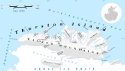
Thurston Island (category Coordinates on Wikidata)
Navy Operation Highjump in December 1946. Named by the United States Advisory Committee on Antarctic Names (US-ACAN) for Carl O. Petersen, radio engineer...
30 KB (5,268 words) - 01:50, 5 October 2024
Mount Craddock (category Coordinates on Wikidata)
climbed in January 1992. The name Mount Craddock was originally recommended by the Advisory Committee on Antarctic Names (US-ACAN) in 1965 for the present-day...
3 KB (349 words) - 11:36, 2 November 2024
Charles Peak (category Wikipedia articles incorporating text from the USGS Geographic Names Information System)
surveys and from U.S. Navy air photos, 1961–66, and named by the Advisory Committee on Antarctic Names for Charles E. Williams, meteorologist at Little America...
796 bytes (106 words) - 15:22, 8 August 2024
Kyle Hills (category Coordinates on Wikidata)
Local relief of features is on the order of 200 metres (660 ft). Named by United States Advisory Committee on Antarctic Names (US-ACAN) (2000) after Philip...
17 KB (3,129 words) - 15:32, 19 July 2024
Everett Range (category Coordinates on Wikidata)
was named by the United States Advisory Committee on Antarctic Names (US-ACAN) for Commander William H. Everett, U.S. Navy, Commander of Antarctic Squadron...
8 KB (1,211 words) - 14:42, 10 March 2024
Dotson Ice Shelf (category Wikipedia articles incorporating text from the USGS Geographic Names Information System)
Navy Operation Highjump in January 1947, and was named by the Advisory Committee on Antarctic Names for Lieutenant William A. Dotson, US Navy, formerly...
2 KB (255 words) - 12:57, 16 August 2024
Bush Mountains (category Coordinates on Wikidata)
Freeze (1956–63). The Bush Mountains were named by the Advisory Committee on Antarctic Names (US-SCAN) on the recommendation of Rear Admiral Richard...
6 KB (690 words) - 15:28, 14 January 2024
Siple Island (category Wikipedia articles incorporating text from the USGS Geographic Names Information System)
to record footing on the island. The island and the mountain were named by the United States Advisory Committee on Antarctic Names (US-ACAN) in 1967 in...
3 KB (248 words) - 11:21, 6 October 2024
Algae Lake (category Wikipedia articles incorporating text from the USGS Geographic Names Information System)
U.S. Navy Operation Highjump, 1946–47, and named "Algae Inlet" by the Advisory Committee on Antarctic Names because of the algae reported by Operation...
3 KB (159 words) - 04:32, 1 December 2023
Brunt Ice Shelf (category Wikipedia articles incorporating text from the USGS Geographic Names Information System)
Survey from air photos obtained at that time. It was named by the Advisory Committee on Antarctic Names in association with the Brunt Ice Shelf. In 2012,...
5 KB (519 words) - 12:53, 16 August 2024
Carney Island (category Coordinates on Wikidata)
Operation Highjump (OpHjp) in January 1947. It was named by the United States Advisory Committee on Antarctic Names (US-ACAN) after Admiral Robert Carney (1895–1990)...
5 KB (645 words) - 11:18, 6 October 2024
Alexandra Mountains (category Coordinates on Wikidata)
Named by the United States Advisory Committee on Antarctic Names (US-ACAN) for Captain Samuel A. Youngman, United States Navy, medical officer on the...
7 KB (1,133 words) - 01:44, 7 July 2024
Graham Land (category British Antarctic Territory)
between the British Antarctic Place-names Committee and the US Advisory Committee on Antarctic Names, in which the name "Antarctic Peninsula" was approved...
5 KB (482 words) - 12:35, 3 October 2024
Palmer Land (category British Antarctic Territory)
agreement between the Advisory Committee on Antarctic Names and the UK Antarctic Place-Names Committee, in which the name Antarctic Peninsula was approved...
3 KB (359 words) - 12:34, 3 October 2024
Amundsen Sea (redirect from Weak underbelly of West Antarctic Ice Sheet)
Navy (USN) Operation HIGHJUMP in December 1946, and named by the Advisory Committee on Antarctic Names for the USS Pine Island, seaplane tender and flagship...
12 KB (1,968 words) - 12:01, 8 February 2024
Hughes Range (Antarctica) (category Coordinates on Wikidata)
Richard E. Byrd on the baselaying flight of November 18, 1929. It was named by the Advisory Committee on Antarctic Names (US-ACAN) on the recommendation...
13 KB (2,134 words) - 14:38, 24 June 2024
Mount Discovery (category Coordinates on Wikidata)
the north end of Hurricane Ridge on the west margin of Discovery Glacier. Named by Advisory Committee on Antarctic Names (US-ACAN) (1999) in association...
5 KB (654 words) - 10:43, 16 April 2024
Mount Terra Nova (category Commons category link is on Wikidata)
Oamaru Peak. At the suggestion of P.R. Kyle, named by United States Advisory Committee on Antarctic Names (US-ACAN) (2000) after David A. Caldwell, geologist...
6 KB (830 words) - 14:19, 19 July 2024
Finnemore Peak (category Wikipedia articles incorporating text from the USGS Geographic Names Information System)
Victoria Land. Named in 2005 by the Advisory Committee on Antarctic Names after Michelle Rogan-Finnemore who wintered twice with the U.S. Antarctic Program:...
989 bytes (158 words) - 17:28, 18 July 2024
Mount Andrus (category Coordinates on Wikidata)
States Navy air photographs, 1964–68. It was named by the United States Advisory Committee on Antarctic Names (US-ACAN) for Lt. Carl H. Andrus, United States...
3 KB (295 words) - 16:26, 16 April 2024
Doolittle Bluff (category Wikipedia articles incorporating text from the USGS Geographic Names Information System)
a summit area at 1,835 metres (6,020 ft). It was named by the Advisory Committee on Antarctic Names (1997) after John H. (Jack) Doolittle, an American...
1 KB (202 words) - 09:47, 2 July 2021
Dater Glacier (category Wikipedia articles incorporating text from the USGS Geographic Names Information System)
It was named by the Advisory Committee on Antarctic Names after Henry M. Dater, a historian on the staff of the U.S. Antarctic Projects Officer and the...
3 KB (254 words) - 00:37, 15 May 2024


