
An aeromagnetic survey is a common type of geophysical survey carried out using a magnetometer aboard or towed behind an aircraft. The principle is similar...
5 KB (558 words) - 16:33, 1 April 2025
of Mars and Jupiter. According to the British Antarctic Survey's (BAS) aeromagnetic 1975 survey of Astraea Nunatak and nearby Ceres Nunataks, this geographical...
5 KB (666 words) - 15:18, 13 September 2023
planets Mars and Jupiter. According to the British Antarctic Survey's (BAS) aeromagnetic 1975 survey of Ceres Nunataks and nearby Astraea Nunatak, this geographical...
5 KB (670 words) - 05:52, 21 February 2024

field). Military MAD equipment is a descendant of geomagnetic survey or aeromagnetic survey instruments used to search for minerals by detecting their disturbance...
7 KB (805 words) - 15:25, 8 January 2025

(such as aeromagnetic surveys and gravity measurements). It can also refer to a chart or map made by analyzing a region from the air. Aerial survey should...
9 KB (793 words) - 07:44, 24 February 2025
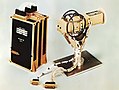
Magnetometer (section Survey magnetometers)
Systematic surveys can be used to in searching for mineral deposits or locating lost objects. Such surveys are divided into: Aeromagnetic survey Borehole...
75 KB (9,473 words) - 01:45, 26 February 2025

Magnetic anomaly (section Aeromagnetic)
on a cable. Aeromagnetic surveys have a lower spatial resolution than ground surveys, but this can be an advantage for a regional survey of deeper rocks...
19 KB (2,038 words) - 14:10, 11 March 2025
1895 - July 15, 1989) was an American geologist best known for her aeromagnetic surveying work. Jespersen began her career as a teacher before commencing...
7 KB (730 words) - 10:54, 22 August 2024
Profit of a company Residual noise remaining after compensation in an aeromagnetic survey Heat absorption and transfer quality for a solar cooker Computational...
3 KB (343 words) - 20:25, 16 March 2025

Geomatics (redirect from Survey engineering)
Application areas include: Aeromagnetic surveys Airborne geophysics Air navigation services Archaeological excavation and survey for GIS applications Coastal...
18 KB (1,720 words) - 18:19, 14 February 2025
Curie depth (category Geophysical survey)
encounter the Curie temperature. This depth can be approximated from aeromagnetic survey data through spectral analysis or forward modeling. Artemieva, Irina...
2 KB (221 words) - 09:28, 18 December 2020

Soviet Space Agency; offshore oil platform support; exploration and aeromagnetic survey for natural resources; support for construction projects; transport...
75 KB (7,514 words) - 03:48, 6 April 2025

(1994). The Azores triple junction evolution since 10 Ma from an aeromagnetic survey of the Mid-Atlantic Ridge. Vol. 125. Earth and Planetary Science...
110 KB (10,841 words) - 12:20, 6 April 2025
discovered as result of an aeromagnetic survey of the Soldiers Cap Group in the eastern Mount Isa inlier. The area was selected for survey based upon extrapolations...
9 KB (905 words) - 08:40, 5 November 2023
Operation Coldfeet began in May 1961, when a naval aircraft flying an aeromagnetic survey over the Arctic Ocean reported sighting an abandoned Soviet drift...
6 KB (731 words) - 23:58, 13 August 2023
the United States Geological Survey (USGS), who was USGS project chief on a cooperative USGS–German aeromagnetic survey over the Butcher Ridge – Cook...
21 KB (3,482 words) - 23:58, 20 February 2025

076 °F). If magnetite is in a large enough quantity it can be found in aeromagnetic surveys using a magnetometer which measures magnetic intensities. Solid magnetite...
51 KB (5,381 words) - 18:44, 7 April 2025

and semiconductor devices' construction. Abraham–Lorentz force Aeromagnetic surveys Computational electromagnetics Double-slit experiment Electrodynamic...
38 KB (4,163 words) - 22:48, 18 March 2025

Outline of geophysics (section Magnetic survey)
Viscous remanent magnetization Plate reconstruction Aeromagnetic survey Geophysical survey Magnetic survey (archaeology) Magnetometer Age of the Earth Geochronology...
12 KB (1,048 words) - 22:35, 1 September 2024

56 kilometers. It was compiled from satellite, marine, aeromagnetic and ground magnetic surveys. As of 2018[update], the latest version, EMM2017, includes...
79 KB (8,967 words) - 02:25, 9 March 2025

standard agricultural layout. One aircraft has been converted for aeromagnetic survey. A disadvantage in the utility role is the low internal volume available...
8 KB (832 words) - 06:50, 20 November 2024
gravity anomalies (its dense basaltic rock increases gravity locally), aeromagnetic surveys, and seismic data. A slightly older but possibly related geologic...
16 KB (1,636 words) - 09:16, 5 April 2025
of survey is carried out to discover the structure of rock formations beneath the surface of the Earth. Magnetic techniques, including aeromagnetic surveys...
21 KB (2,959 words) - 22:04, 26 November 2024
These results were confirmed and built upon by the high-altitude aeromagnetic surveys carried out by the US Naval Oceanographic Office, as well as by the...
6 KB (692 words) - 16:36, 2 December 2023
intrusives overlain by thin Tertiary sands and recent sand dunes. Aeromagnetic surveys show the presence of a high concentration of crustal scale fractures...
8 KB (973 words) - 16:37, 9 April 2025

methods These methods include: Shallow seismic surveys Ground-penetrating radar Aeromagnetic surveys Electrical resistivity tomography They aid in: Hydrocarbon...
87 KB (9,679 words) - 19:36, 4 April 2025
Zimbabwean Government engaged Scout Aerial Africa to undertake an Aeromagnetic survey, and produce a drilling programme, with maps showing potential areas...
11 KB (758 words) - 07:05, 4 February 2024

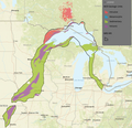
their location determined by high-resolution seismic reflection and aeromagnetic surveys. The northernmost strand lies nearly along Interstate 90 and then...
35 KB (3,384 words) - 20:33, 10 November 2024

methods such as ground-penetrating radar (GPR), aeromagnetic surveys, and seismic reflection surveys. Faults can be dated in absolute terms using radiocarbon...
8 KB (725 words) - 19:05, 10 April 2025

soils, or lakes. In modern searches, geophysical methods such as aeromagnetic surveys, electrical resistivity, and gravimetry, help identify promising...
140 KB (15,156 words) - 22:27, 6 April 2025