
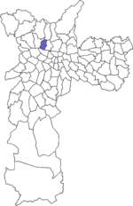
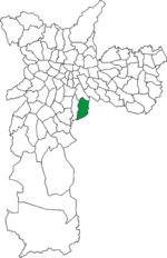
Aricanduva is a district in the subprefecture of the same name in the city of São Paulo, Brazil. It is located along the west bank of the Aricanduva River...
4 KB (133 words) - 10:45, 24 August 2023

Territórios e identidades: estudo de caso do bairro da Liberdade - São Paulo, SP". Immigration Museum of the State of São Paulo ("Museu da Imigração do Estado")...
16 KB (1,521 words) - 05:27, 8 January 2025

Brasil dos primeiros séculos. Terceira edição. São Paulo: Global, 2005. p. 168 "Jabaquara - Guia do bairro Jabaquara -SP Aqui você Encontra !". www.encontrajabaquara...
3 KB (186 words) - 12:49, 8 January 2025
Alto de Pinheiros is a district in the subprefecture of Pinheiros of the West Zone of São Paulo, Brazil. 23°32′57″S 46°42′51″W / 23.54917°S 46.71417°W...
3 KB (40 words) - 09:29, 10 September 2022
em São Paulo: trajetórias, conflitos e negociações na metrópole. Fapesp. Ferreira, Barros (1971). O nobre e antigo bairro da Sé. São Paulo: São Paulo City...
30 KB (3,994 words) - 09:26, 9 November 2023
in the city of São Paulo, emerged at the end of the 19th century after the establishment of the Sorocabana Railway (1875), the São Paulo Railway (1967)...
13 KB (1,385 words) - 11:09, 21 November 2024

of São Paulo, Brazil. It is primarily commercial but has industrial and residential areas. The district is served by Line 1 (Blue) of the São Paulo Metro...
11 KB (1,254 words) - 12:02, 29 August 2024
São Paulo, called Distritos (districts), are subdivisions of the boroughs, without a self-government. Some districts are further divided into bairros...
12 KB (251 words) - 04:44, 31 March 2024

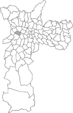
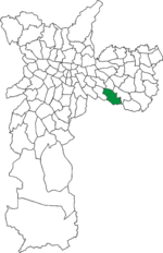
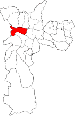
is an administrative district of the São Paulo, with 75,000 residents as of 2005. It belongs to the Aricanduva sub-prefecture. Carrão is located about...
8 KB (814 words) - 22:01, 26 November 2024

Monastery of Saint Benedict (Portuguese: Mosteiro de São Bento) is a Catholic temple located in São Paulo, Brazil. Established on 14 July 1598, the current...
21 KB (2,195 words) - 04:30, 25 May 2024
São Miguel Paulista is a district in the subprefecture of the same name in the city of São Paulo, Brazil. The Roman Catholic Diocese of São Miguel Paulista...
5 KB (468 words) - 14:17, 10 January 2025

Aclimação Park (category Buildings and structures in São Paulo)
2024-04-25. "Da Aclimação". São Paulo City Hall. 14 March 2024. Retrieved 2024-04-25. Oliveira, Abrahão (2014-07-02). "O bairro que nasceu ao redor do parque:...
10 KB (1,109 words) - 21:31, 2 December 2024

Consolação Street (category Streets in São Paulo)
da Consolação) is an important thoroughfare in the Brazilian city of São Paulo. It begins in the central area of the city, near the Anhangabaú Valley...
8 KB (734 words) - 20:13, 18 February 2025
of São Paulo in the same year. "Dados Demográficos dos Distritos pertencentes as Subprefeituras". prefeitura.sp.gov.br (in Portuguese). City of São Paulo...
3 KB (130 words) - 12:04, 12 September 2024

Várzea do Carmo (category Central Zone of São Paulo)
São Paulo Central Zone of São Paulo Sousa, Diógenes (2022). "Nas redes do Pari: os armazéns da São Paulo Railway no contexto urbanístico de São Paulo...
9 KB (1,013 words) - 08:40, 4 February 2024

Largo do Arouche (category Squares in São Paulo)
in the city of São Paulo Largo São Bento Largo de São Francisco Amadio, Decio (2005). Desenho urbano e bairros centrais de São Paulo: um estudo sobre...
14 KB (1,454 words) - 00:27, 5 January 2025
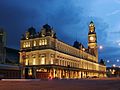
Luz Station (category Railway stations in São Paulo)
to São Paulo Metro Line 1-Blue and ViaQuatro Line 4-Yellow via its underground metro station of the same name. It is currently located in Bairro da Luz...
14 KB (1,491 words) - 14:55, 15 December 2024
Subprefecture of Lapa (category Subprefectures of São Paulo)
The Subprefecture of Lapa is one of 32 subprefectures of the city of São Paulo, Brazil. It comprises six districts: Lapa, Barra Funda, Perdizes, Vila...
4 KB (193 words) - 09:31, 10 September 2022

Bixiga (category Neighbourhoods in São Paulo)
Vai-Vai Roman Catholic Archdiocese of São Paulo Memória do Bixiga Museum Bixiga: os contornos atuais do bairro que começou com imigrantes calabreses Museu...
8 KB (716 words) - 14:56, 30 April 2024

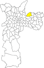
23.6036°S 46.465°W / -23.6036; -46.465 São Mateus is one of 96 districts in the city of São Paulo, Brazil. São Mateus is a district located in the eastern...
3 KB (138 words) - 14:32, 11 September 2024

Água Rasa (redirect from Água Rasa (district of São Paulo))
Prefeitura da Cidade de São Paulo". Retrieved 31 December 2014. "Subprefeitura Mooca - Portal da Prefeitura da Cidade de São Paulo". Retrieved 31 December...
4 KB (110 words) - 16:25, 22 October 2022

Vila Leopoldina (redirect from Vila Leopoldina (district of São Paulo))
Leopoldina is a district in the subprefecture of Lapa in the city of São Paulo, Brazil. It originated as an extension of the Lapa district and initially...
6 KB (621 words) - 14:15, 22 January 2025
Limão (redirect from Limão (district of São Paulo))
-46.6721 Bairro do Limão is a neighborhood in the Limão district located in the northern part of the city of São Paulo, in the state of São Paulo, Brazil...
3 KB (136 words) - 16:54, 20 August 2024

Igreja Nossa Senhora do Brasil (category Roman Catholic churches in São Paulo)
the Cross in the church. Tourism in the city of São Paulo Ponciano, Levino (2001). Bairros Paulistanos de A a Z. Senac. p. 12. ISBN 978-85-7359-223-8. Retrieved...
6 KB (538 words) - 13:52, 3 May 2024

Largo da Batata (category Squares in São Paulo)
the original on 2005-01-20. "BAIRRO DE PINHEIROS | Secretaria Municipal de Cultura | Prefeitura da Cidade de São Paulo". www.prefeitura.sp.gov.br (in...
4 KB (366 words) - 20:45, 9 November 2023

Vila Madalena (category Neighbourhoods in São Paulo)
Guide: São Paulo". The Economist. Moreno, Ricardo (February 2014). "Vila Madalena—São Paulo". Monocle magazine. "Vila Madalena – Guia do bairro Vila Madalena...
3 KB (233 words) - 02:34, 9 October 2024
Torcida Jovem (category Samba schools of São Paulo)
group of fans from São Paulo, the group set out to make it a goal to attend every match that the club played in the capital of São Paulo. With over 70,000...
41 KB (2,358 words) - 15:46, 28 November 2024
Cangaíba (redirect from Cangaíba (district of São Paulo))
96 districts in the city of São Paulo, Brazil. The district is situated on the east side of the Brazilian city of São Paulo, with 136.623 residents, according...
4 KB (224 words) - 04:52, 12 March 2023

district within the subprefecture of Perus in São Paulo, Brazil. "Portal da Prefeitura da Cidade de São Paulo". Archived from the original on 30 August 2012...
3 KB (60 words) - 15:22, 22 August 2023
Sacomã (redirect from Sacomã (district of São Paulo))
city of São Paulo, Brazil. Sacomã is a district located in the southeast region of the municipality of São Paulo, in the state of São Paulo, Brazil....
3 KB (161 words) - 13:47, 3 September 2024