
State Route 66 (SR 66) is a surface road in the U.S. state of Arizona in Mohave and Coconino Counties. In 1914, the road was designated "National Old...
7 KB (550 words) - 18:00, 24 March 2024

U.S. Route 66 (US 66, Route 66) also known as the Will Rogers Highway, was a major United States Numbered Highway in the state of Arizona from November...
149 KB (16,036 words) - 12:11, 26 August 2024

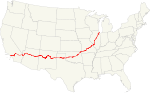
U.S. Route 66 or U.S. Highway 66 (US 66 or Route 66) was one of the original highways in the United States Numbered Highway System. It was established...
85 KB (8,874 words) - 16:42, 25 August 2024

U.S. Route 66 (US 66, Route 66) is a part of a former United States Numbered Highway in the state of California that ran from the west in Santa Monica...
25 KB (1,950 words) - 03:26, 3 August 2024

US 66 / US 466 served the western terminus of Arizona State Route 62 (SR 62), which was the main route connecting Chloride to the rest of the state highway...
13 KB (1,260 words) - 06:43, 29 June 2024

County, Arizona, United States. As of the 2020 census it had a population of 39. Valentine is located on Arizona State Route 66 (former U.S. Route 66) 32...
5 KB (271 words) - 15:21, 19 April 2024
US 66. Alabama State Route 66 Arizona State Route 66* Arkansas Highway 66 California State Route 66* County Route 66 (California)* Colorado State Highway...
7 KB (539 words) - 22:51, 7 August 2024
U.S. Bicycle Route 66 (USBR 66) is a United States Bicycle Route that follows the former U.S. Route 66 (US 66) across the United States. The first section...
14 KB (1,287 words) - 02:21, 17 July 2023

State Route 77 (SR 77) is a 253.93-mile (408.66-kilometre) long state highway in Arizona that traverses much of the state's length, stretching from its...
23 KB (1,926 words) - 21:54, 4 August 2024

State Route 89A (SR 89A) is an 83.85-mile (134.94 km) state highway that runs from Prescott north to Flagstaff in the U.S. state of Arizona. The highway...
28 KB (2,153 words) - 20:37, 19 August 2024

State Route 79 (SR 79), also known as the Pinal Pioneer Parkway, is a 58.40 mi (93.99 km) long state highway in the U.S. state of Arizona. It serves as...
19 KB (1,925 words) - 00:36, 5 August 2024

S. Route 93 Arizona State Route 66 Business Loop 40 and Arizona SR 66 are composed of the remnants of what was U.S. Route 66. Arizona State Route 68 Interstate...
42 KB (4,136 words) - 03:04, 15 August 2024

Phoenix to northern Arizona) in Flagstaff. For the majority of its routing through Arizona, I-40 follows the historic alignment of US 66. The lone exception...
32 KB (2,323 words) - 00:55, 5 August 2024

in northwestern Arizona, United States. The population was 456 at the 2020 census. It is one of the stops on historic U.S. Route 66. Seligman is located...
27 KB (2,477 words) - 19:43, 19 August 2024

State Route 87 (SR 87) is a 272.66-mile (438.80 km) north–south highway that travels from I-10 near Picacho northward to State Route 264 near Second Mesa...
12 KB (736 words) - 02:06, 2 August 2024
summary of the former state routes in Arizona, including mileage tables and maps. Between the establishment of Arizona's numbered state highway system in...
93 KB (8,965 words) - 22:00, 4 August 2024
census-designated place (CDP) in Mohave County, Arizona, United States. It is located on Arizona State Route 66 (former U.S. Route 66) 28 miles (45 km) northeast of Kingman...
12 KB (1,151 words) - 15:04, 19 April 2024

State Route 89 (SR 89) is a 104.53-mile (168.22 km) state highway in the U.S. state of Arizona. It is part of the former route of U.S. Route 89 (US 89)...
5 KB (254 words) - 04:36, 19 March 2024
Route 66. They exist in all 8 Route 66 states: Illinois, Missouri, Kansas, Oklahoma, Texas, New Mexico, Arizona and California. The first Route 66 Association...
9 KB (930 words) - 20:27, 3 August 2024
state of Arizona's State Routes are usually abbreviated as SR. The Arizona State Highway system was introduced on September 9, 1927, by the State Highway...
50 KB (1,442 words) - 23:47, 19 July 2024

Springs is in eastern Mohave County on both sides of Arizona State Route 66 (historic U.S. Route 66). It is 50 miles (80 km) northeast of Kingman and 37...
11 KB (994 words) - 17:35, 19 April 2024

Arizona State Route 101 (SR 101) or Loop 101 is a semi-beltway looping around the Phoenix Metropolitan Area in central Arizona, United States. It connects...
25 KB (1,731 words) - 16:30, 25 July 2024
State Route 30 (formerly State Route 801), also known as the I-10 Reliever, is a planned state highway in the southwest parts of Phoenix, Arizona and nearby...
17 KB (1,571 words) - 01:38, 5 August 2024

Arizona State Route 202 (SR 202) or Loop 202 (202L) is a semi-beltway circling the eastern and southern areas of the Phoenix metropolitan area in central...
45 KB (3,331 words) - 16:31, 25 July 2024

State Route 88 is a long state highway in the U.S. state of Arizona. It runs from U.S. Route 60 (US 60) in Apache Junction through desert terrain to SR...
14 KB (1,175 words) - 17:07, 23 August 2024
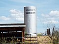
A Route 66 museum is a museum devoted primarily to the history of U.S. Route 66, a U.S. Highway which served the states of California, Arizona, New Mexico...
11 KB (1,205 words) - 07:49, 1 July 2022

U.S. Route 93 (US 93) is a United States Numbered Highway in the state of Arizona that begins in Wickenburg and heads north to the Nevada state line at...
27 KB (2,971 words) - 01:46, 5 August 2024
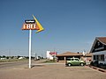
Midpoint Café (category Buildings and structures on U.S. Route 66)
"Historic Route 66" back on the map date to 1987, with Angel Delgadillo's Arizona Historic Route 66 Association obtaining historic signage on Arizona State Route...
11 KB (1,077 words) - 21:18, 21 May 2024

U.S. Route 191 (US 191) is a north–south U.S. Highway in eastern Arizona. The highway runs for 516.50 miles (831.23 km), making it Arizona's longest numbered...
47 KB (4,567 words) - 01:40, 5 August 2024
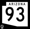
Arizona State Route 93, abbreviated SR 93, was a state highway in Arizona that existed from 1946 to 1991. The route was co-signed with other highways...
26 KB (2,193 words) - 00:36, 5 August 2024