
The Arrondissement of Rouen is an arrondissement of France in the Seine-Maritime department in the Normandy region. It has 216 communes. Its population...
14 KB (976 words) - 13:24, 25 March 2022
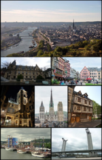
Rouen (UK: /ˈruːɒ̃, ˈruːɒn/, US: /ruːˈɒ̃, ruːˈɒn/; French: [ʁwɑ̃] or [ʁu.ɑ̃])[needs Norman IPA] is a city on the River Seine in northern France. It is...
41 KB (3,799 words) - 22:36, 26 June 2024

in 2016. Arrondissement of Rouen, (prefecture of the Seine-Maritime department: Rouen) with 216 communes. The population of the arrondissement was 631...
2 KB (201 words) - 23:02, 10 February 2024

Rives-en-Seine. Caudebec-en-Caux is located 27 miles (43 km) W.N.W. of Rouen, on the right bank of the River Seine. The tidal bore in the estuary of...
7 KB (809 words) - 00:32, 25 December 2023
Rouen is subdivided into 3 cantons: Canton of Rouen-1 (pop. 38,082) Canton of Rouen-2 (pop. 36,051) Canton of Rouen-3 (pop. 37,424) Arrondissements of...
1 KB (112 words) - 11:55, 25 March 2022

Sotteville-lès-Rouen (French pronunciation: [sɔtvil lɛ ʁwɑ̃], literally Sotteville near Rouen) is a commune and railway town in the Seine-Maritime department...
4 KB (272 words) - 22:25, 12 December 2023
fabric production. Until 1926, Yvetot had been chef-lieu of the old arrondissement of Yvetot, and a sub-prefecture. During this period of reorganisation...
7 KB (698 words) - 02:58, 28 January 2024

March 1884, in 5th arrondissement, Paris – 8 April 1936, in Paris) more commonly known as Pierre Dumont, was a French painter of the Rouen School. He was...
3 KB (275 words) - 01:32, 8 April 2024

town is the fifth-largest suburb of the city of Rouen and lies directly adjacent to the north side of Rouen at the junction of the D121 and D43. In addition...
7 KB (592 words) - 17:22, 5 August 2023
Villequier (category Rouen geography stubs)
banks of the river Seine in the Pays de Caux, some 23 miles (37 km) west of Rouen near the junction of the D281 with the D81 road. The church of St. Pierre...
3 KB (202 words) - 23:17, 10 December 2022

the arrondissements of Seine-Maritime, it received 12 communes from the arrondissement of Le Havre and four communes from the arrondissement of Rouen, and...
19 KB (1,309 words) - 13:24, 25 March 2022

Petit-Couronne (category Rouen geography stubs)
by the banks of the Seine, just 4 miles (6.4 km) south of the centre of Rouen at the junction of the D3 and the N338 roads. Menhirs from pre-Roman times...
4 KB (203 words) - 12:31, 23 September 2022

Déville-lès-Rouen (French pronunciation: [devil lɛ ʁwɑ̃], literally Déville near Rouen) is a commune in the Seine-Maritime department of the Normandy region...
4 KB (223 words) - 20:24, 27 April 2023
Saint-Wandrille-Rançon (category Rouen geography stubs)
situated by the banks of the Seine, some 18 miles (29 km) north-west of Rouen at the junction of the D22, D33 and the D982 roads. Until 1960, the Pont...
4 KB (336 words) - 10:34, 27 January 2022

former province of Normandy. In 1800 five arrondissements were created within the département, namely Rouen, Le Havre, Dieppe, Neufchatel and Yvetot,...
15 KB (742 words) - 13:40, 30 December 2023

village situated in the Pays de Caux, some 30 miles (48 km) northwest of Rouen at the junction of the D33, D34 and the D110 roads. The church of St.Quentin...
3 KB (188 words) - 23:30, 13 April 2022

0.7444 Country France Region Normandy Department Seine-Maritime Arrondissement Rouen Canton Yvetot Intercommunality CC Plateau de Caux-Doudeville-Yerville...
2 KB (119 words) - 18:33, 14 August 2023

Jumièges (category Rouen geography stubs)
situated in a meander of the river Seine, some 21 kilometres (13 mi) west of Rouen, at the junction of the D 65 and the D 143 roads. A ferry service operates...
4 KB (321 words) - 07:23, 28 August 2023

charter. The village then developed along the road connecting Paris to Rouen. During the fifteenth and sixteenth centuries the parish had five hundred...
8 KB (749 words) - 05:35, 26 February 2024

hilltop suburb of Rouen, semi-rural, semi-suburban with a little farming and some light industry. It is considered part of Greater Rouen, being just five...
7 KB (682 words) - 20:59, 27 September 2023
Autretot (category Rouen geography stubs)
village situated in the Pays de Caux, some 23 miles (37 km) northwest of Rouen on the D131 road. The commune has the distinction of having been awarded...
2 KB (128 words) - 09:52, 27 January 2022
La Mailleraye-sur-Seine (category Rouen geography stubs)
situated by the banks of the river Seine, some 16 miles (26 km) west of Rouen, at the junction of the D65, D131 and the D490 roads. The church of St.Mathurin...
2 KB (153 words) - 22:52, 1 May 2023
Fréville, Seine-Maritime (category Rouen geography stubs)
village situated in the Pays de Caux, some 16 miles (26 km) northwest of Rouen, at the junction of the D5, D22 and the D20 roads. The church of St.Martin...
2 KB (112 words) - 07:30, 28 September 2022

Gardner-Serpollet (section 1894 Paris-Rouen)
his factory with his brother Henri on the rue des Cloÿs in the 18th arrondissement of Paris, a location that has become the Parc Léon Serpollet today....
7 KB (588 words) - 17:02, 9 June 2024

525; 0.723 Country France Region Normandy Department Seine-Maritime Arrondissement Rouen Canton Port-Jérôme-sur-Seine Intercommunality Caux Seine Agglo Government...
2 KB (109 words) - 12:08, 4 December 2022

the river Crevon in the Pays de Caux, some 10 miles (16 km) northeast of Rouen, at the junction of the D12, D7 and the D98 roads. Medieval place-name in...
5 KB (474 words) - 12:38, 3 May 2024
Veauville-lès-Baons (category Rouen geography stubs)
village situated in the Pays de Caux, some 24 miles (39 km) northwest of Rouen at the junction of the C5 with the D37 road. The A29 autoroute passes through...
2 KB (157 words) - 09:53, 27 January 2022
Estouteville-Écalles (category Rouen geography stubs)
village situated in the Pays de Caux, some 14 miles (23 km) northeast of Rouen, at the junction of the D98 and the D919 roads. Three churches, in the three...
2 KB (118 words) - 09:51, 27 January 2022
Grand-Couronne (category Rouen geography stubs)
the banks of the river Seine, some 7 miles (11 km) south of the centre of Rouen, at the junction of the D938, D3 and the D13 roads. The A13 autoroute passes...
3 KB (154 words) - 14:12, 3 June 2024
Saint-Nicolas-de-Bliquetuit (category Rouen geography stubs)
situated in a meander of the river Seine, some 20 miles (32 km) northwest of Rouen at the junction of the D40, D65 and the D490 roads. The 60m high Pont de...
2 KB (139 words) - 22:51, 1 May 2023