
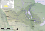
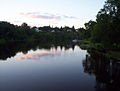
The Assiniboine River (/əˈsɪnɪbɔɪn/ ə-SIN-ih-boyn; French: Rivière Assiniboine) is a 1,070-kilometre (660 mi) river that runs through the prairies of...
16 KB (1,328 words) - 00:19, 2 July 2024

The Assiniboine or Assiniboin people (/əˈsɪnɪbɔɪn/ when singular, Assiniboines / Assiniboins /əˈsɪnɪbɔɪnz/ when plural; Ojibwe: Asiniibwaan, "stone Sioux";...
44 KB (5,139 words) - 16:33, 15 September 2024
the Red's confluence with the Assiniboine River, at a point called The Forks. Together with the Assiniboine, the Red River fully encloses the endorheic...
26 KB (2,366 words) - 00:28, 4 August 2024

located in the southwestern corner of the province on the banks of the Assiniboine River, approximately 214 kilometres (133 mi) west of the provincial capital...
47 KB (3,366 words) - 02:42, 29 September 2024
Fur trading on the Assiniboine River and the general area west of Lake Winnipeg, in what is now Manitoba, Canada, began as early as 1731. Lake Winnipeg...
13 KB (1,601 words) - 13:55, 8 August 2024
the Assiniboine River near Treesbank, about 25 miles (40 km) southeast of Brandon. The main tributaries of the Souris in Manitoba are the Antler River, Gainsborough...
13 KB (976 words) - 17:31, 24 July 2024

Downtown Winnipeg (section Broadway-Assiniboine)
is an area of Winnipeg located near the confluence of the Red and Assiniboine rivers. It is the oldest urban area in Winnipeg, and is home to the city's...
28 KB (2,489 words) - 06:54, 3 September 2024

bounded on the north by the line of 52° N latitude roughly from the Assiniboine River east to Lake Winnipegosis. It then formed a line of 52° 30′ N latitude...
46 KB (5,910 words) - 01:02, 14 August 2024
The 2011 Assiniboine River flood was caused by above average precipitation in Western Manitoba and Saskatchewan. This was a 1 in 300 year flood that affected...
13 KB (1,498 words) - 02:23, 3 September 2024

Assiniboine Park (formerly known as City Park) is a park in Winnipeg, Manitoba, Canada, located along the Assiniboine River. The Winnipeg Public Parks...
13 KB (1,532 words) - 02:52, 3 September 2024
History of flooding in Canada (redirect from 1894 Fraser River flood)
"statistical probability of a similar flood each year." The 2011 Assiniboine River Flood was estimated to have a return interval of 300 years. The Calgary...
77 KB (8,861 words) - 13:12, 14 September 2024

explored the Red and Assiniboine River valleys, and in 1858, the Assiniboine, Souris, Qu'Appelle, and South Saskatchewan River valleys. The expeditions...
18 KB (2,530 words) - 02:15, 25 September 2024

Lake Winnipeg watershed Winnipeg River Red River Assiniboine River Qu'Appelle River Souris River Saskatchewan River Lake Winnipegosis watershed Contents...
4 KB (296 words) - 06:05, 8 September 2024

The Forks, Winnipeg (redirect from Assiniboine Credit Union River Trail)
in downtown Winnipeg located at the confluence of the Red River and the Assiniboine River. The Forks was designated a National Historic Site of Canada...
58 KB (5,102 words) - 07:13, 3 September 2024

1950. When the river crested at the James Avenue pumping station in Winnipeg, north of the confluence of the Red and Assiniboine rivers, the measured open-water...
6 KB (529 words) - 18:10, 19 September 2024
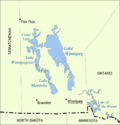
the Assiniboine River. Lake Manitoba drains northeast into Lake Winnipeg through the Fairford River to Lake St. Martin and then to the Dauphin River. The...
16 KB (1,730 words) - 16:57, 23 July 2024
see Fort-Rupert for James Bay. Ottawa River, Winnipeg River, Assiniboine River fur trade, and Saskatchewan River fur trade. Contents A B C D E F G H I...
25 KB (1,686 words) - 16:24, 21 August 2024

Mount Assiniboine, also known as Assiniboine Mountain, is a pyramidal peak mountain on the Great Divide, on the British Columbia/Alberta border in Canada...
6 KB (417 words) - 00:23, 14 August 2024
St. James-Assiniboia (redirect from City of St. James-Assiniboine)
the Canadian National Railway's Oak Point line, on the south by the Assiniboine River, on the west by the Rural Municipality of Headingley, and on the east...
23 KB (1,928 words) - 04:47, 1 August 2024

years, the confluence of the Red and Assiniboine rivers—whose access had previously been controlled by the Assiniboine people—had been a meeting place for...
20 KB (2,239 words) - 03:36, 22 August 2024
River MacLennan River Bow River Nipekamew River Nipekamew Creek Assiniboine River Qu'Appelle River Moose Jaw River Avonlea Creek Thunder Creek Wascana Creek...
12 KB (549 words) - 15:58, 3 July 2024

subtotals for the Assiniboine, Red, Winnipeg, and Saskatchewan rivers, which feed into the Nelson. Derived by adding the length of the Peace River (measured from...
63 KB (2,899 words) - 22:40, 3 June 2024

Municipality of Headingley on the West. Its boundaries are Roblin and the Assiniboine River to the north, Shaftesbury Boulevard on the East, Wilkes Avenue to...
17 KB (1,480 words) - 14:10, 22 September 2024

Egypt in terms of usefulness.” The construction of the floodway and Assiniboine River works, would entail a capital cost of over $72 million, amortized...
20 KB (2,280 words) - 14:03, 14 August 2024

Manitoba in Canada. It is centred on the confluence of the Red and Assiniboine rivers, near the longitudinal centre of North America. As of 2021[update]...
152 KB (12,133 words) - 02:56, 27 September 2024

The 2014 Assiniboine River flood was caused by above average precipitation in western Manitoba and Saskatchewan. Unlike most prior floods, this flood...
11 KB (1,136 words) - 04:56, 24 April 2024

Winnipeg has three major rivers: the Red River, the Assiniboine River, and the Seine River. The Red River is a Canadian heritage river. Because of Winnipeg's...
33 KB (3,360 words) - 15:54, 19 January 2024

The Assiniboine River Bridge is a railway bridge situated 8 km east of Portage la Prairie, Manitoba, Canada. The bridge is located at Mile 50.4 in Canadian...
3 KB (438 words) - 03:12, 25 December 2023

Lake Agassiz (category Lakes of the Mississippi River)
Sheyenne River, the Pembina River, and finally the Assiniboine River. Initially, Lake Souris' southern bay drained into the Sheyenne River, a tributary...
41 KB (4,310 words) - 23:00, 27 July 2024
languages Places Assiniboine River, a river that runs through the prairies of Western Canada in Saskatchewan and Manitoba Mount Assiniboine in eastern British...
964 bytes (150 words) - 09:24, 27 August 2022