
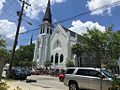
the 2010 census. Awendaw is part of the Charleston, South Carolina metropolitan area. Awendaw was named by the Sewee tribe. Awendaw is thought to mean...
11 KB (1,007 words) - 12:30, 27 September 2024
Boulevard (SC 703) in Mount Pleasant, and its transmitter is located in Awendaw, South Carolina. The station signed on the air as WUSN-TV on September...
13 KB (1,067 words) - 21:31, 8 August 2024

Clementia Awendaw-McClellanville Consolidated Fire District, made up of unincorporated parts of Northern Charleston County, the Town of Awendaw, and the...
50 KB (4,094 words) - 13:50, 14 August 2024

cities within the area code are in bold. Andrews Atlantic Beach Aynor Awendaw Beaufort Bennettsville Bethune Blenheim Bluffton Briarcliffe Acres Carolina...
7 KB (481 words) - 18:24, 6 February 2024
the West Ashley section of Charleston, and its transmitter is located in Awendaw, South Carolina. Both the studio and road are named for long-time WCSC...
18 KB (2,094 words) - 10:59, 20 September 2024
17/701 (Johnnie Dodds Boulevard) in Mount Pleasant and a transmitter in Awendaw, South Carolina. In September 2014, due to complications arising from Sinclair's...
18 KB (1,756 words) - 13:18, 6 October 2024

American origin, and settlers in South Carolina commonly called it Owendaw or Awendaw in reference to the local Sewee tribe town. Recipes similar to spoonbread...
7 KB (814 words) - 23:12, 30 May 2024
considering having a new Lincoln High built in Awendaw. Bowers, Paul (2016-06-02). "Replacement site in Awendaw considered". The Post and Courier. Retrieved...
1 KB (119 words) - 05:13, 31 August 2024

stated that they were considering having a new Lincoln High constructed in Awendaw. Cape Romain Environmental Education Charter School (CREECS) is a charter...
13 KB (1,117 words) - 00:30, 7 May 2024

609.6 m (2,000 ft) 1986 Guyed mast VHF-UHF transmission United States Awendaw, South Carolina Tallest structure in South Carolina (equal) 32°55′29.0″N...
59 KB (504 words) - 17:13, 26 August 2024

Pleasant Scarp and the north by the Awendaw Scarp. The Little Wambaw Swamp drains north through a gap in the Awendaw Scarp into the Wambaw Swamp proper...
5 KB (438 words) - 00:47, 6 May 2024
Simmons (74) – a pastor who also served at Greater Zion AME Church in Awendaw. Sharonda Coleman-Singleton (45) – a pastor; also a speech therapist and...
174 KB (14,755 words) - 14:05, 5 October 2024

by the collapse of their homes. The U.S. Route 17 bridge across Awendaw Creek in Awendaw was destroyed by a 19.4 ft (5.9 m) storm tide. Extensive losses...
148 KB (16,129 words) - 23:11, 9 October 2024
located on Arco Lane in North Charleston, and its transmitter is located in Awendaw, South Carolina. The station began operations on September 7, 1985, as...
15 KB (1,551 words) - 11:35, 2 October 2024
transmitter in North Charleston"; the TV transmitter sites are actually in Awendaw. The filmmakers were required to include on-screen disclaimers at the beginning...
17 KB (1,954 words) - 05:21, 20 August 2024

Francis Marion National Forest and going through the rural communities of Awendaw and McClellanville, where Hurricane Hugo made landfall in September 1989...
29 KB (2,697 words) - 19:31, 14 September 2024

a strong tropical storm. Two hours later, the storm made landfall near Awendaw, South Carolina with winds of 75 mph (121 km/h). Gaston weakened rapidly...
114 KB (10,893 words) - 06:48, 8 October 2024

river in the coastal area of South Carolina. It begins in the town of Awendaw, Charleston County, and has its mouth at the Cooper River shortly before...
3 KB (155 words) - 11:29, 21 March 2023

is owned by Howard Stirk Holdings. WGWG's transmitter is located near Awendaw, South Carolina. From 1962 through 2014, what is now WGWG was the original...
19 KB (1,618 words) - 21:31, 8 August 2024
the 2020 Census Allendale (80.0%) Andrews (60.8%) Atlantic Beach (82.1%) Awendaw (64.6%) Bamberg (53.6%) Bennettsville (63.2%) Bishopville (65.8%) Blackville...
76 KB (5,096 words) - 09:46, 7 October 2024
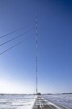
40083°W / 33.48083; -87.40083 (WTTO Tower) Guyed Mast 609.6 m WCSC-Tower Awendaw, South Carolina 32°55′29″N 079°41′57″W / 32.92472°N 79.69917°W / 32...
49 KB (62 words) - 19:55, 16 September 2024

(267 km²) National Wildlife Refuge in southeastern South Carolina near Awendaw, South Carolina. The refuge lands and waters encompass water impoundments...
6 KB (632 words) - 17:12, 10 September 2024

Council–manager Horry 195 334 −41.6% 0.162 0.4 1,203.7/sq mi (464.8/km2) Awendaw Town Council Charleston 1,399 1,294 +8.1% 17.346 44.93 80.7/sq mi (31.1/km2)...
84 KB (885 words) - 16:23, 5 May 2024

Moncks Corner (County Seat) Hollywood Sangaree (census-designated place) Awendaw Folly Beach Isle of Palms Kiawah Island Lincolnville Meggett Ravenel Ridgeville...
18 KB (1,175 words) - 16:58, 9 October 2024

Hermine. 10 a.m. EDT (1400 UTC) – Hurricane Gaston makes landfall near Awendaw, South Carolina with 75 mph (121 km/h) winds. 8 p.m. EDT (0000 UTC, August...
31 KB (3,098 words) - 15:51, 21 August 2024
Communications WCSC Television Tower (Charleston CBS 5) Height: 2,000 ft (609.6 m) Awendaw (32°55′29″N 079°41′57″W / 32.92472°N 79.69917°W / 32.92472; -79.69917)...
37 KB (5,240 words) - 09:59, 28 September 2024

is 263,904 acres (1,070 km2) in size. The forest contains the towns of Awendaw, Huger, Jamestown, and McClellanville. Charleston provides emergency services...
5 KB (395 words) - 01:06, 8 October 2024
colony of Carolana in 1682 to include the colony's lands stretching from Awendaw Creek north to the western shore of Winyah Bay and inland. In 1685, the...
4 KB (508 words) - 18:31, 26 September 2024
McConnells, South Carolina $15,831 186 Bonneau, South Carolina $15,799 187 Awendaw, South Carolina $15,781 188 Lakewood, South Carolina $15,736 189 Varnville...
24 KB (96 words) - 20:33, 9 April 2022

depression on September 19, while located about 245 mi (394 km) southeast of Awendaw, South Carolina. The system, which had an "extremely small diameter", moved...
19 KB (1,738 words) - 02:28, 21 May 2024