
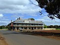
Cadoux is a town in the northeastern Wheatbelt region of Western Australia. It is about 180 kilometres (112 mi) northeast of Perth, within the Shire of...
4 KB (387 words) - 20:03, 9 March 2024
Bungulla Bunjil Buntine Burakin Burekup Burracoppin Busselton (city) Byford Cadoux Caiguna Calingiri Camballin Cape Burney Capel Carbunup River Carcoola Carnamah...
23 KB (753 words) - 11:57, 3 August 2024
just east of Cadoux that was felt in Perth. 1979: WAY 1979 and the publishing of the Sesquicentenary Celebrations Series (Western Australia) by the celebrations...
63 KB (6,523 words) - 21:07, 9 October 2024

Wagin /ˈweɪdʒɪn/ is a town and shire in the Wheatbelt region of Western Australia, approximately 225 km (139.81 mi) south-east of Perth on the Great Southern...
14 KB (1,217 words) - 12:33, 1 August 2024

The Wheatbelt is one of nine regions of Western Australia defined as administrative areas for the state's regional development, and a vernacular term...
18 KB (1,526 words) - 04:20, 1 May 2024
on 13 September 2009. "The Cadoux Earthquake, 2 June 1979". Seismicity of Western Australia. University of Western Australia. 28 March 2004. Retrieved...
32 KB (1,095 words) - 13:17, 12 September 2024

colloquially called Dally, is a town in the Wheatbelt region of Western Australia, located 248 km from Perth via the Great Northern Highway. Agriculture...
9 KB (512 words) - 07:53, 25 August 2024

townsite located 177 km north of Perth in the Wheatbelt region of Western Australia. At the 2021 census, Moora had a population of 1,755. Moora was one...
9 KB (577 words) - 13:19, 5 September 2023
Campion is an abandoned townsite in the Wheatbelt region of Western Australia, located in the Shire of Nungarin on the Koorda–Bullfinch Road. It is situated...
7 KB (665 words) - 14:52, 30 August 2024
damaging earthquake in Western Australia's recorded history hit with a magnitude of 6.1. The epicentre was close to the town of Cadoux in the Wheatbelt region...
22 KB (2,558 words) - 06:06, 3 May 2024

Mukinbudin is a small town in the north eastern Wheatbelt region of Western Australia, approximately 298 kilometres (185 mi) east of Perth and 80 kilometres...
7 KB (373 words) - 06:30, 30 August 2024

York is the oldest inland town in Western Australia, situated on the Avon River, 97 kilometres (60 mi) east of Perth in the Wheatbelt, on Ballardong Nyoongar...
50 KB (5,084 words) - 16:14, 24 August 2024

Southern Cross is a town in Western Australia, 371 kilometres (230.5 miles) east of state capital Perth on the Great Eastern Highway. It was founded in...
13 KB (953 words) - 12:18, 14 September 2024

Narembeen is a town in the Wheatbelt region of Western Australia. It is 286 km, almost due east, from Perth, the capital of WA. It is the major settlement...
9 KB (543 words) - 11:32, 30 July 2024
Dudinin is a small remote town located in the Shire of Kulin in Western Australia, with a population of 72. Dudinin is located 37 kilometres southeast...
3 KB (186 words) - 11:36, 30 July 2024
Irishtown is a locality in the Wheatbelt region of Western Australia near Northam. It is situated 7 km (4 mi) to the north of Northam and 85 km (53 mi)...
1 KB (78 words) - 11:44, 12 March 2024

Hyden is located 292 kilometres (181 mi) east-southeast of Perth, Western Australia in the Shire of Kondinin. Hyden is home to Wave Rock, Mulka's Cave...
6 KB (647 words) - 15:55, 8 February 2023

and 1910, is a town on the Avon River in the Wheatbelt region of Western Australia, 85 kilometres (53 mi) north-east of Perth. The first European settlement...
26 KB (2,551 words) - 18:50, 18 September 2024
Dumbleyung is a town and shire in the Wheatbelt region of Western Australia, 267 kilometres (166 mi) south-east of Perth between Wagin and Lake Grace...
5 KB (545 words) - 12:06, 30 July 2024

Quairading is a Western Australian town located in the Wheatbelt region. It is the seat of government for the Shire of Quairading. The town was named for...
13 KB (1,337 words) - 20:53, 10 September 2024

Nungarin is a town located in the north east of the Wheatbelt region of Western Australia, approximately 278 kilometres (173 mi) east of Perth and 39 kilometres...
12 KB (866 words) - 08:08, 9 September 2024

Yealering is a town in the Wheatbelt region of Western Australia, approximately 220km south-east of Perth between the towns of Wickepin and Corrigin....
5 KB (499 words) - 01:07, 28 July 2024
Moodiarrup (redirect from Moodiarrup, Western Australia)
Moodiarrup is a locality in Western Australia, located to the south of Darkan within the Shire of West Arthur. The locality is situated at an average...
1 KB (92 words) - 06:54, 27 June 2024

Koorda is a town in the north eastern Wheatbelt region of Western Australia, approximately 236 kilometres (147 mi) east of Perth and 43 kilometres (27 mi)...
6 KB (379 words) - 06:27, 30 August 2024

Trayning is a town in the north-eastern Wheatbelt region of Western Australia, 236 kilometres (147 mi) east of the state capital, Perth, on the Nungarin–Wyalkatchem...
8 KB (550 words) - 10:28, 26 August 2024

Lake Grace in Western Australia. The townsite was gazetted in 1925 and honours Sir Francis Newdegate, the Governor of Western Australia from 1920 to 1924...
5 KB (464 words) - 08:04, 28 July 2024

Wandering is a town located in the Wheatbelt region of Western Australia, approximately 120 kilometres (75 mi) from the state capital, Perth, just off...
8 KB (586 words) - 05:34, 11 August 2023

Williams is a town located in the Wheatbelt region of Western Australia, 161 kilometres (100 mi) south-southeast of the state capital, Perth along Albany...
9 KB (761 words) - 11:25, 5 August 2024

townsite in the Wheatbelt region of Western Australia, 45 kilometres north-north-east of Northam, Western Australia. The surrounding areas produce wheat...
7 KB (425 words) - 10:23, 26 August 2024
Bullfinch is a small town in the eastern Wheatbelt region of Western Australia. The town was gazetted in 1910. Gold mining is its largest industry. Gold...
4 KB (313 words) - 15:10, 30 August 2024