
Cape Columbia is the northernmost point of land of Canada, located on Ellesmere Island in the Qikiqtaaluk Region of Nunavut. It marks the westernmost...
4 KB (406 words) - 05:45, 26 July 2024

boundaries of Canada is Cape Columbia, Ellesmere Island, Nunavut 83°06′40″N 69°58′19″W / 83.111°N 69.972°W / 83.111; -69.972 (Cape Columbia, Nunavut). The...
12 KB (1,578 words) - 21:10, 20 December 2024

Queen Elizabeth Islands. Cape Columbia at 83°06′41″N 069°57′13″W / 83.11139°N 69.95361°W / 83.11139; -69.95361 (Cape Columbia) is the most northerly...
58 KB (6,694 words) - 21:31, 20 April 2025

a body of water in the Arctic Ocean, stretching from Cape Columbia, Canada, in the west to Cape Morris Jesup, Greenland, in the east. The northern limit...
12 KB (1,409 words) - 22:40, 17 February 2025

17 km (11 mi) stretch of northern coast of Ellesmere Island around Cape Columbia is more northerly. The island is 5.0 km (3.1 mi) long, east to west...
7 KB (791 words) - 22:26, 15 December 2022

boundary. The distance to the northernmost point of land in Canada—Cape Columbia, Ellesmere Island—is 4,640 kilometres (2,883 miles). The southernmost...
9 KB (932 words) - 20:34, 22 September 2024

Headland (redirect from Cape (headland))
Labrador/Nunavut Cape Columbia, Nunavut, Canada's northernmost point Cape Freels, Newfoundland and Labrador Cape Norman, Newfoundland and Labrador Cape Spear, Newfoundland...
6 KB (581 words) - 11:14, 3 March 2025

expedition to the North Pole 1970 Qaanaaq to Cape Columbia 1970 Western Greenland, a nautical expedition 1971 Cape Columbia to the North Pole by sled 1973 Himalaya...
5 KB (440 words) - 20:54, 31 August 2024
Ellesmere Island; through the North shore of Ellesmere Island to Cape Columbia thence a line to Cape Morris Jesup (Greenland). Note that these definitions exclude...
49 KB (6,537 words) - 02:50, 28 March 2025

northernmost point is Cape Columbia, Ellesmere Island, Nunavut, Canada 83°8′N 74°13′W / 83.133°N 74.217°W / 83.133; -74.217 (Cape Columbia). Southernmost...
18 KB (2,609 words) - 12:32, 10 November 2024

ISBN 978-1-4930-1322-7. Coast Guard station Cape Disappointment website Jacklet, Ben (2004-10-19). "Columbia pilot pay attracts port's eye". Portland Tribune...
9 KB (954 words) - 08:33, 25 May 2024
Island Cormorandière Rocks (near Scatarie Island) Brier Island Nunavut Cape Columbia, Ellesmere Island, near Alert. Northernmost point of land in Canada...
6 KB (70 words) - 04:17, 20 March 2025
ventured North in 1909, has grown enormously since we set out from Cape Columbia. Having now seen for myself how he travelled across the pack ice, I...
75 KB (7,998 words) - 20:33, 1 April 2025

Cape Beale Lightstation is an active manned lighthouse on Vancouver Island in British Columbia, Canada. The lighthouse was built in 1874 and its focal...
8 KB (294 words) - 00:23, 10 November 2024
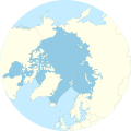
of Ellesmere Island, Nunavut, Canada. Situated on the north coast, Cape Columbia, it is the northernmost point of Canada, only 770 km from the North...
1 KB (105 words) - 21:06, 11 July 2023

February 15, Bartlett's pioneer division departed the Roosevelt for Cape Columbia, followed by 5 advance divisions. Peary, with the two Inuit, Arco and...
65 KB (7,600 words) - 17:24, 24 April 2025
approximately 840 km (520 mi) to the north, Cape Columbia is however some 75 km (47 mi) closer to the Pole. Cape Sheridan was the wintering site of Robert...
4 KB (613 words) - 06:07, 26 July 2024

Stevens was established on the south bank of the Columbia River. In 1864, the post was renamed Fort Cape Disappointment. Some Civil War-era fortifications...
8 KB (659 words) - 05:59, 1 August 2023
boundaries of Canada is Cape Columbia, Ellesmere Island, Nunavut 83°06′40″N 69°58′19″W / 83.111°N 69.972°W / 83.111; -69.972 (Cape Columbia, Nunavut). The...
55 KB (7,027 words) - 04:09, 21 April 2025
States, on the north side of the Columbia River bar (across from Oregon) and just west of Baker Bay. The point of the cape is located on the Pacific Ocean...
4 KB (469 words) - 03:51, 15 December 2024
Columbia through the mountains. Travel from the rest of Canada before 1885 meant the difficulty of overland travel via the United States, around Cape...
174 KB (15,719 words) - 05:53, 22 April 2025

The Cape Disappointment Light is a lighthouse on Cape Disappointment near the mouth of the Columbia River in the U.S. state of Washington. In 1848, it...
4 KB (368 words) - 06:28, 4 February 2024

States Coast Guard Station Cape Disappointment, situated near Cape Disappointment, Washington, at the mouth of the Columbia River, is the largest United...
12 KB (1,111 words) - 17:54, 6 March 2025
Island, British Columbia. The 22,294-hectare (55,090-acre) provincial park is about 563 km (350 mi) northwest of Victoria. In 1786, the cape was named in...
22 KB (1,731 words) - 21:13, 13 October 2024

telegram to Elmira reporting, "Drowned April 10, 1909 45 mile north of Cape Columbia while returning from 86 degrees 38 minutes North Latitude." However...
15 KB (1,493 words) - 03:43, 11 March 2025
Esquimalt Naval & Military Museum, Esquimalt, British Columbia. Fleet Maintenance Facility Cape Breton was formed in 1996 at CFB Esquimalt from the amalgamation...
13 KB (1,239 words) - 13:29, 12 March 2025
Cape Disappointment can refer to: Cape Disappointment (Washington), at the mouth of the Columbia River in western Washington State Cape Disappointment...
416 bytes (81 words) - 21:09, 12 September 2020

feet below the Lincoln Sea, between the Wandel Sea in the east and Cape Columbia, Canada in the west), which was pushed up when Greenland moved northwards...
13 KB (1,345 words) - 20:55, 23 December 2024
Prince Patrick Island, and Cape Columbia, Ellesmere Island. On the Northeast. The Coast of Ellesmere Island between C. Columbia and C. Sheridan the Northern...
125 KB (13,449 words) - 22:58, 24 April 2025

University of British Columbia Library. Retrieved 2023-11-16. MacGillivray, Allister (1981), The Cape Breton Fiddler, College of Cape Breton Press. ISBN 0-920336-12-4...
7 KB (742 words) - 09:52, 19 January 2025