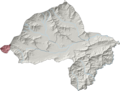
Central Kurram Tehsil is a subdivision located in Kurram District, Khyber Pakhtunkhwa, Pakistan. The population is 229,356 according to the 2017 census...
4 KB (132 words) - 08:43, 15 June 2024

population. Kurram District is currently subdivided into three Tehsils. Central Kurram Tehsil (Urdu: تحصیل کرم وسطی)(Pashto: منځنی کرم تحصیل) Lower Kurram Tehsil...
27 KB (2,769 words) - 02:57, 18 August 2024

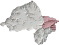
Upper Kurram Tehsil is a subdivision located in Kurram District, Khyber Pakhtunkhwa, Pakistan. The population is 253,478 according to the 2017 census....
5 KB (244 words) - 10:11, 19 March 2024

Tehsil Gumbat Tehsil Kohat Tehsil Lachi Tehsil Central Kurram Tehsil Lower Kurram Tehsil Upper Kurram Tehsil Central Orakzai Tehsil Ismail Zai Tehsil...
6 KB (457 words) - 12:13, 15 July 2024
Lower Kurram Tehsil is a subdivision located in Kurram District, Khyber Pakhtunkhwa, Pakistan. The population is 136,719 according to the 2017 census....
4 KB (162 words) - 10:16, 19 March 2024

Tehsil, Orakzai Agency (south) Central Orakzai Tehsil, Orakzai Agency (south) Upper Orakzai Tehsil, Orakzai Agency (southwest) Central Kurram Tehsil,...
6 KB (311 words) - 14:28, 28 May 2024
Central Orakzai Tehsil is a subdivision located in Orakzai District, Khyber Pakhtunkhwa, Pakistan. The population is 59,122 according to the 2017 census...
3 KB (62 words) - 08:43, 15 June 2024
Khost, Afghanistan. It is Tehsil headquarters of Lower Kurram. Kurram Valley is divided into three tehsils. The Alizai Tehsil jurisdiction start from Sakhi...
5 KB (279 words) - 14:40, 11 April 2024

Bettani Tehsil is an administrative subdivision (tehsil) of Lakki Marwat District in Khyber Pakhtunkhwa province of Pakistan. This subdivision shares...
10 KB (815 words) - 21:08, 3 August 2024

"trans-border tract" of land which encompassed five "Political Agencies": Khyber, Kurram, Malakand, Tochi, and Wano. The four districts Bannu, Dera Ismail Khan,...
44 KB (3,227 words) - 16:58, 22 July 2024
Mir Ali Tehsil is a subdivision located in North Waziristan district, Khyber Pakhtunkhwa, Pakistan. The population is 185,525 according to the 2017 census...
3 KB (76 words) - 10:11, 19 March 2024

comprises two Tehsils, Upper Tehsil and Ismailzai Tehsil, and the Lower sub-division also has two Tehsils, Lower Tehsil and Central Tehsil. The land of...
22 KB (2,370 words) - 04:17, 4 September 2024

Mullagori Tehsil is a subdivision located in Khyber District, Khyber Pakhtunkhwa, Pakistan. It is located among the Tahtara hills on its west side and...
11 KB (1,105 words) - 15:49, 14 August 2024
Ambar Utmankhel Tehsil is a subdivision located in Mohmand District, Khyber Pakhtunkhwa, Pakistan. The population is 62,109 according to the 2017 census...
3 KB (62 words) - 10:16, 19 March 2024

nine tehsils: Datta Khel Tehsil, Dossali Tehsil, Gharyum Tehsil, Ghulam Khan Tehsil, Mir Ali Tehsil, Miran Shah Tehsil, Razmak Tehsil, Shewa Tehsil, Spinwam...
31 KB (3,235 words) - 02:36, 18 August 2024
Halim Zai Tehsil is a subdivision located in Mohmand District, Khyber Pakhtunkhwa, Pakistan. The population is 78,749 according to the 2017 census. Ghalanai...
3 KB (64 words) - 10:11, 19 March 2024

borders Nangarhar Province to the west, Orakzai District to the south, Kurram District to southwest, Peshawar to the east and Mohmand District to the...
14 KB (1,029 words) - 13:54, 31 August 2024
Serwekai Tehsil is a subdivision located in South Waziristan district, Khyber Pakhtunkhwa, Pakistan. The population is 54,278 according to the 2017 census...
3 KB (56 words) - 18:37, 16 August 2024
Bar Chamarkand Tehsil (Pashto: بار چمرکنډ تحصیل), alternatively written Bar Chamar Kand is an administrative subdivision (tehsil) of Bajaur District in...
8 KB (605 words) - 11:38, 24 March 2024
Ismailzai Tehsil is a subdivision located in Orakzai District, Khyber Pakhtunkhwa, Pakistan. The population is 23,965 according to the 2017 census. List...
3 KB (61 words) - 10:16, 19 March 2024
province of Pakistan. It consists of five districts: Hangu, Karak, Kohat, Kurram, and Orakzai. The division borders Bannu Division to the south and west...
24 KB (2,424 words) - 15:51, 19 August 2024

Khar Bajaur Tehsil (Pashto: خار باجوړ تحصیل), sometimes shortened to Khar Tehsil, is an administrative subdivision (tehsil) of Bajaur District in Khyber...
8 KB (608 words) - 20:51, 24 March 2024

gradually slopes to the central part, which looks like a basin. A large number of streams flow from the surrounding hills. The Kurram river flows through...
12 KB (1,017 words) - 04:00, 18 August 2024
Hassan Khel Tehsil is an administrative subdivision (tehsil) of Peshawar District in Khyber Pakhtunkhwa province of Pakistan. This subdivision borders...
7 KB (272 words) - 08:55, 14 October 2023

Toi Khullah Tehsil is a subdivision located in Lower South Waziristan District District, Khyber Pakhtunkhwa, Pakistan. The population is 50,593 according...
3 KB (56 words) - 10:16, 19 March 2024
Upper Orakzai Tehsil is a subdivision located in Orakzai District, Khyber Pakhtunkhwa, Pakistan. The population is 63,872 according to the 2017 census...
3 KB (65 words) - 10:11, 19 March 2024
Prang Ghar (redirect from Pringhar Tehsil)
Prang Ghar is a tehsil located in Mohmand District, Khyber Pakhtunkhwa, Pakistan. It's about 70km from Peshawar. The population is 35,290 according to...
5 KB (318 words) - 10:16, 19 March 2024
District's central-eastern shoulder, Utman Khel shares a 19.95 km border with Barang Tehsil to the south, a 13.30 km border with Khar Bajaur Tehsil to the...
6 KB (424 words) - 00:44, 21 March 2024
Ekka Ghund Tehsil is a subdivision located in Mohmand District, Khyber Pakhtunkhwa, Pakistan. The population is 52,291 according to the 2017 census. List...
3 KB (53 words) - 10:16, 19 March 2024
Dossali Tehsil is a subdivision located in North Waziristan district, Khyber Pakhtunkhwa, Pakistan. The population is 39,821 according to the 2017 census...
3 KB (67 words) - 19:14, 27 July 2024