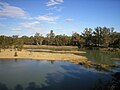
Colignan is a small rural town on the banks of the Murray River, in North Western Victoria, Australia. The town is on the border of the Hattah-Kulkyne...
4 KB (291 words) - 05:52, 11 May 2023
This is a list of government schools in Victoria, Australia. Broadmeadows Secondary College merged into Hume Central Secondary College Croydon Secondary...
396 KB (252 words) - 08:56, 14 October 2024
area had a population of 153. Nangiloc and nearby localities Iraak and Colignan were established as soldier settlement farming areas after World War I...
4 KB (296 words) - 10:05, 7 May 2023
locality in Victoria, Australia, located approximately 35 km south-east of Mildura, Victoria. Iraak and nearby localities Nangiloc and Colignan were established...
5 KB (138 words) - 01:18, 8 August 2024

(Boonoonar, Ginquam, Ginquam South, Nowingi, Yatpool, Yatpool West) • Colignan • Cowangie (Bunurouk, Bunurouk West, Cowangie North, Daalko, Koonoa, Kow...
136 KB (12,146 words) - 05:09, 28 June 2024
Carwarp is a locality in Victoria, Australia, approximately 36 km from Mildura, Victoria. Carwarp was the home town of Percy Stewart, a founding member...
5 KB (190 words) - 09:45, 7 May 2023

County of Karkarooc (category Counties of Victoria (state))
Cocamba, Victoria Colignan, Victoria Cronomby, Victoria Curyo, Victoria Dattuck, Victoria Daytrap, Victoria Dennying, Victoria Dering, Victoria Dewry, Victoria...
5 KB (370 words) - 02:47, 23 February 2024
Millewa (category Victoria (state) articles missing geocoordinate data)
nineteenth century. In the 1960s the then dryland farming areas of Nangiloc and Colignan were irrigated. Subsequently, they became less seen as being in the Millewa...
2 KB (221 words) - 18:58, 10 July 2023

Road routes in Victoria assist drivers navigating roads throughout the state, as roads may change names several times between destinations, or have a second...
178 KB (1,277 words) - 07:12, 18 September 2024
Hattah (redirect from Hattah, Victoria)
Hattah is a locality in Victoria, Australia located approximately 70 km south of Mildura. Located adjacent to Hattah is the Hattah-Kulkyne National Park...
3 KB (152 words) - 02:17, 23 August 2023

Soldier settlement (section Victoria)
Renmark Victoria Birdwoodton Gringegalgona Merbein West Mortlake Numurkah Red Cliffs (including the township of Cardross) Karadoc/Carwarp/Colignan (including...
30 KB (3,140 words) - 08:23, 7 August 2024
1956 Murray River flood (category Floods in Victoria (state))
the towns of Wentworth in New South Wales; Colignan, Iraak, Mildura, Nangiloc, and Red Cliffs in Victoria; and many South Australia towns including Renmark...
8 KB (618 words) - 12:49, 7 May 2023

Calder Highway (category Highways in Victoria (state))
highway in Australia, linking Mildura and the Victoria/New South Wales border to Bendigo, in North Central Victoria. South of Bendigo, where the former highway...
45 KB (3,105 words) - 12:24, 6 October 2024

Rural City of Mildura (category Local government areas of Victoria (state))
The Rural City of Mildura is a local government area in Victoria, Australia, located in the north-western part of the state. It covers an area of 22,083...
13 KB (820 words) - 03:08, 2 July 2024

Shire of Mildura (category Former local government areas of Victoria (state))
Mildura was a local government area located at the northwestern corner of Victoria, Australia, on the Murray River and the South Australian border. The shire...
5 KB (338 words) - 11:35, 12 May 2023