
The Cordillera Vilcanota (Spanish cordillera: "mountain range", Aymara: willkan uta "house of the sun") is a mountain range located in Peru southeast of...
15 KB (1,610 words) - 02:44, 29 May 2024
Vilcanota may refer to: Vilcanota River (Rio Vilcanota), a segment of the Urubamba River in Peru Cordillera Vilcanota, a mountain range in the Cusco Region...
437 bytes (74 words) - 17:15, 1 June 2014
Rentema Cordillera Huayhuash Cordillera Negra Cordillera Occidental (Peru) Cordillera Oriental (Peru) Cordillera Vilcanota Huaguruncho mountain range Huallanca...
8 KB (486 words) - 15:34, 7 July 2024

Paleozoic metamorphic rocks. It includes many subsidiary ranges such as the Vilcanota, Vilcabamba, Urubamba and Carabaya mountain ranges and peaks above 6,000 m...
1 KB (87 words) - 16:47, 30 May 2024

tropical highlands of southern Peru, in the Cordillera Oriental/eastern Andes. The Cordillera Vilcanota mountain range is ten kilometres (6.2 mi) northwest...
109 KB (12,853 words) - 13:30, 28 July 2024
Huandoy Cordillera Blanca 9°1′41″S 77°39′50″W / 9.02806°S 77.66389°W / -9.02806; -77.66389 (Huandoy) Peru 6,380 Ausangate Cordillera Vilcanota 13°47′19″S...
61 KB (174 words) - 21:34, 18 April 2024

2005, op. cit., attaches three peaks including the Salcantay to the Cordillera Vilcanota instead of Vilcabamba, but this was identified as a typo, and all...
10 KB (883 words) - 12:51, 18 July 2024

Country Bolivia, Peru Physical characteristics Source • location Cordillera Vilcanota, Peru • coordinates 12°53′17.0808″S 71°21′36.1944″W / 12.888078000°S...
11 KB (339 words) - 01:30, 13 August 2024
Peru. The wingspan is about 31 mm. The species name refers to the Cordillera Vilcanota, the type locality. Wikimedia Commons has media related to Sisurcana...
1 KB (82 words) - 14:58, 3 July 2024

pampa plain) or Pico Tres (Spanish for "peak three") is a mountain in the Vilcanota mountain range in the Andes of Peru, about 6,093 metres (19,990 ft) high...
5 KB (402 words) - 21:17, 13 March 2024
(Canada). February, 1977. 1977 West Face, Extremo (Huayna) Ausangate, Cordillera Vilcanota, Peru. First ascent of face with Lorenzo Ortas (Spain). June, 1977...
19 KB (1,974 words) - 22:47, 15 August 2024
75 km. It is located in the Puno Region, Carabaya Province, between the Vilcanota mountain range in the north-west and the Apolobamba mountain range in...
3 KB (192 words) - 12:13, 8 April 2021
Pirámide de Garcilaso and Alpamayo in the Cordillera Blanca, and Jutunhuma and Cayungate I in the Cordillera Vilcanota, AAJ 11, p. 108 (1958) Noyce and Cox...
143 KB (3,887 words) - 20:10, 23 July 2024
Quechua (PDF). La Paz, Bolivia: futatraw.ourproject.org. John Ricker, Cordillera Vilcanota—1969, AAC (American Alpine Club) Publications Taken from Mountaineering...
2 KB (187 words) - 22:23, 15 April 2022

the pattern recorded elsewhere in Peru such as in the Cordillera Blanca, Cordillera Vilcanota and the mountains Ampato, Quelccaya and Sabancaya. All...
126 KB (13,485 words) - 21:49, 28 July 2024
mountain caracara") is a 5,085-metre-high (16,683 ft) mountain in the Vilcanota mountain range in the Andes of Peru. It is situated in the Cusco Region...
2 KB (109 words) - 05:18, 15 April 2022
17,854 ft" Jill Neate, taken from Mountaineering in the Andes, "Cordillera Vilcanota, Payachata Group, Quimsachta 5442m: 3-topped, pyramidal peak: 1-1969...
3 KB (189 words) - 22:23, 15 April 2022
Quechua (PDF). La Paz, Bolivia: futatraw.ourproject.org. John Ricker, Cordillera Vilcanota—1969, AAC (American Alpine Journal Publications v t e v t e...
2 KB (131 words) - 23:47, 16 April 2023

restoration efforts are currently underway at three locations in the Cordillera Vilcanota (Abra Malaga, Hulloc and Cancha-Cancha) under the guidance of the...
6 KB (709 words) - 09:39, 13 September 2023

(2018). "Avian nesting and roosting on glaciers at high elevation, Cordillera Vilcanota, Peru". Wilson Journal of Ornithology. 130 (4): 940–957. doi:10.1676/1559-4491...
2 KB (122 words) - 09:39, 6 May 2024
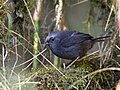
spots throughout. The diademed tapaculo's range extends from the Cordillera Vilcanota in Peru's Department of Cuzco southeast to the Cochabamba Department...
4 KB (434 words) - 07:01, 8 February 2023

Andes at elevations of 2,900 to 4,300 m (9,500 to 14,100 ft) from Cordillera Vilcanota in Peru's Department of Cuzco southeast to Bolivia's Cochabamba Department...
6 KB (726 words) - 03:55, 14 November 2022

(2018). "Avian nesting and roosting on glaciers at high elevation, Cordillera Vilcanota, Peru". Wilson Journal of Ornithology. 130 (4): 940–957. doi:10.1676/1559-4491...
3 KB (235 words) - 18:02, 3 August 2024
Nacional de Glaciares y Lagunas, Inventario de Glaciares de las Cordilleras Vilcanota / Carabaya, ANA (Autoridad Nacional del Agua), see: Jatun Allpapata...
2 KB (160 words) - 03:30, 22 October 2021
lineaments. One of these lineaments is associated with the Cusco and Vilcanota faults which separate the Altiplano into a western and eastern portion...
8 KB (791 words) - 17:14, 17 August 2023
(58 mi) 6- to 10-day Alpamayo Circuit, full "O" Circuit Sacred Valley & Vilcanota mountain range near Cuzco 88 km (55 mi) for the longest Mollepata variant...
36 KB (4,106 words) - 15:35, 2 September 2024

claiming the source to be a small spring in Peru "at the uppermost Río Vilcanota–Urubamba–Ucayali". In a July 1914 interview Besley said he had "vowed...
97 KB (11,537 words) - 22:32, 26 September 2024