Dorchester Avenue (sometimes called Dot Ave) is a street in Boston, Massachusetts, running from downtown south via South Boston and Dorchester to the border...
9 KB (942 words) - 03:24, 26 March 2024

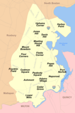
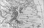
Dorchester is a neighborhood comprising more than 6 square miles (16 km2) in the City of Boston, Massachusetts, United States. Originally, Dorchester...
120 KB (10,716 words) - 16:28, 8 July 2024

Codman Square in the Dorchester neighborhood. The station includes two full-length high-level platforms located north of Talbot Avenue, which are also accessible...
13 KB (1,125 words) - 21:55, 20 May 2024

The Dorchester Railroad and Dorchester Extension Railroad was a horse car line in Boston, Massachusetts in the late 19th century, running from downtown...
3 KB (256 words) - 23:01, 3 July 2020

Channel and abutting Dorchester Bay. It has undergone several demographic transformations since being annexed to the city of Boston in 1804. The neighborhood...
41 KB (4,188 words) - 15:02, 20 June 2024
Massachusetts Dorchester Avenue (Boston) Dorchester Pottery Works, an historic site in Massachusetts Dorchester, Nebraska Dorchester, New Hampshire Dorchester, South...
3 KB (414 words) - 19:45, 12 June 2023
Atlantic Avenue was truncated to just south of Kneeland Street at the S-curve. Traffic formerly using Atlantic Avenue to South Boston now used Dorchester Avenue...
8 KB (944 words) - 12:19, 19 April 2024

Chinatown–Leather District Dorchester (divided for planning purposes into Mid-Dorchester and Dorchester) Downtown East Boston Fenway-Kenmore (includes Longwood)...
19 KB (1,622 words) - 16:57, 29 April 2024

Red Line (MBTA) (redirect from Dorchester Extension)
lines. The Boston Elevated Railway opened its Cambridge tunnel between Harvard and Park Street in 1912. It was extended south as the Dorchester Tunnel to...
75 KB (7,436 words) - 00:07, 13 July 2024
Ashmont Street, Gallivan Blvd., and Dorchester Avenue. The neighborhood was developed after Dorchester's annexation to Boston in 1870. The westerly side of...
2 KB (284 words) - 12:28, 10 July 2017

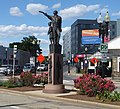
"One Boston Day," held annually on April 15, the foundation sponsored a community clean-up of Dorchester's Peabody Square and Dorchester Avenue. Team...
4 KB (391 words) - 03:33, 8 April 2024

Dorchester High School is a defunct secondary school that was located in Dorchester, Boston, United States from 1852 to 2003. Dorchester High School was...
5 KB (408 words) - 21:56, 29 April 2024

The Dorchester South Burying Ground is a historic graveyard on Dorchester Avenue in the Dorchester neighborhood of Boston, Massachusetts. Established...
2 KB (194 words) - 16:52, 22 June 2024
Boston neighborhood of Dorchester and runs southeast-northwest through Boston, paralleling Interstate 93 for a short distance. Massachusetts Avenue passes...
13 KB (1,007 words) - 13:14, 30 March 2024

KML/Commonwealth Avenue (Boston) KML is from Wikidata Commonwealth Avenue (colloquially referred to as Comm Ave) is a major street in the cities of Boston and Newton...
14 KB (1,210 words) - 20:12, 6 July 2024
Forsythe. The film's title is derived from Blue Hill Avenue, a major street in Roxbury and Dorchester. Tristan (the leader), Simon (the right-hand man),...
8 KB (746 words) - 16:03, 28 June 2024

JFK/UMass station (category Dorchester, Boston)
transfer station, located adjacent to the Columbia Point area of Dorchester, Boston, Massachusetts. It is served by the rapid transit Red Line; the Greenbush...
36 KB (3,643 words) - 21:47, 14 March 2024
Mattapan (redirect from Mattapan, Boston, MA)
(/ˈmætəpæn/) is a neighborhood in Boston, Massachusetts, United States. Mattapan is the original Native American name for the Dorchester area, possibly meaning "a...
30 KB (3,407 words) - 17:57, 23 June 2024
Point, in the Dorchester neighborhood of Boston, Massachusetts, sits on a peninsula jutting out from the mainland of eastern Dorchester into the bay....
42 KB (4,656 words) - 19:59, 17 December 2023

The Dorchester and Milton Branch Railroad was a railroad in Massachusetts. It ran between Neponset Village in Dorchester, Massachusetts, through the town...
6 KB (799 words) - 22:43, 29 June 2023

Hill Avenue station is a regional rail station on the MBTA Commuter Rail Fairmount Line located in the Mattapan neighborhood of Dochester, Boston, Massachusetts...
19 KB (1,757 words) - 21:49, 20 May 2024

69,785 square feet, or 1.6 acres; [4] the convalescent home, Dorchester Avenue, Dorchester, containing 610,500 square feet, or 14 acres; and [5] the relief...
9 KB (518 words) - 17:46, 25 June 2024

Broadway station (MBTA) (category Railway stations located underground in Boston)
station in Boston, Massachusetts. It serves the MBTA's Red Line. It is located at the intersection of Dorchester Avenue and Broadway in South Boston. It was...
17 KB (1,594 words) - 21:28, 21 June 2024

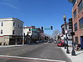
Fields Corner (category Dorchester, Boston)
Fields Corner is a historic commercial district in Dorchester, the largest neighborhood in Boston, Massachusetts, United States founded in June 1630. It...
4 KB (424 words) - 03:27, 11 April 2024
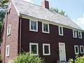
James Blake House (category Landmarks in Dorchester, Boston)
Road, in Edward Everett Square, just a block from Massachusetts Avenue. The Dorchester Historical Society now owns the building and tours are given on...
4 KB (307 words) - 17:25, 22 June 2024

The Lawrence Avenue Historic District is a historic district encompassing a small residential area in the Dorchester neighborhood of Boston, Massachusetts...
3 KB (301 words) - 17:33, 22 June 2024

Dorchester Park is a historic park bounded by Dorchester Avenue, Richmond, Adams and Richview Streets in the Dorchester neighborhood of Boston, Massachusetts...
2 KB (156 words) - 16:52, 22 June 2024

Atlantic Avenue Elevated was an elevated railway around the east side of Downtown Boston, Massachusetts, providing a second route for the Boston Elevated...
12 KB (1,333 words) - 18:29, 26 April 2023

Fields Corner Branch, 1520 Dorchester Avenue, Dorchester. The Fields Corner Branch was opened in 1969 to replace the first Dorchester Branch, which had been...
64 KB (5,843 words) - 10:14, 16 December 2023
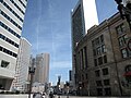
South Boston, northeast of Roxbury, north of Dorchester, and southwest of Bay Village. Despite the name, it is not directly south of downtown Boston. Land...
37 KB (3,930 words) - 16:02, 23 June 2024