
The East Derwent Highway (route number B32) is a highway in Hobart, Tasmania, Australia. The highway is a trunk road that carries heavy commuter traffic...
5 KB (172 words) - 14:30, 7 June 2022

The Highway also acts as a major commuter road to Hobart residents living on the eastern side of the Derwent River. The designation "Tasman Highway" arises...
25 KB (1,373 words) - 10:33, 19 May 2024
listed with a population of 40 for the state suburb of Derwent Bridge. It is on the Lyell Highway at the southern edge of the Cradle Mountain-Lake St Clair...
5 KB (407 words) - 12:03, 12 September 2024

Kettering) Huon Highway (Huonville to Dover) Arthur Highway South Arm Highway (Warrane to Howrah) East Derwent Highway Goodwood Road Tasman Highway (Triabunna...
7 KB (646 words) - 19:07, 20 May 2024
Derwent derives from the Brythonic term Derventio, meaning "valley thick with oaks". It may refer to: Derwent River (Tasmania) Derwent Valley Council,...
6 KB (864 words) - 23:23, 11 March 2024

Bowen Bridge (category River Derwent (Tasmania))
Glenorchy on the western shore. The Bowen Bridge links the East Derwent Highway with the Brooker Highway (as Goodwood Road) at Glenorchy, approximately 10 kilometres...
11 KB (996 words) - 20:34, 19 September 2024

fire station, on Sugarloaf Road, was opened on 14 May 1982. The East Derwent Highway, connects Risdon Vale with Hobart CBD; The Bowen Bridge to Glenorchy;...
4 KB (381 words) - 12:49, 12 September 2024
Herdsmans Cove, Tasmania (category Populated places on the River Derwent)
boundary. The East Derwent Highway forms the northern and eastern boundaries. Route B32 (East Derwent Highway) passes to the north and east. Access is provided...
4 KB (216 words) - 12:50, 12 September 2024

Yellowhead Highway (Highway 16) at Vermilion. About 7 kilometres (4 mi) east Derwent, Highway 41 shares a 4-kilometre (2 mi) concurrency with Highway 45 before...
17 KB (555 words) - 05:36, 27 August 2024

Hobart (category Populated places on the River Derwent)
state of Tasmania, Australia. Located in Tasmania's south-east on the estuary of the River Derwent, it is the southernmost capital city in Australia. Despite...
144 KB (12,974 words) - 03:42, 10 October 2024
Eastern Ring Road is a proposed Link between the South Arm Highway and the East Derwent Highway, within the greater area of Hobart, Tasmania. The idea behind...
4 KB (379 words) - 23:30, 7 December 2021
development of two new major connecting highways, the east-heading Tasman Highway, and the north-heading East Derwent Highway, greatly improving access both to...
64 KB (7,091 words) - 13:29, 5 October 2024
as a highway, but without a highway name. For example, Great Southern Highway is classified as a main road, not as a highway, or Hereward Highway in the...
24 KB (399 words) - 08:34, 6 June 2024

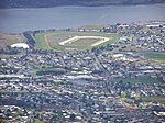
Glenorchy, from there it travels east past the Elwick Racecourse, over the Bowen Bridge and connects to the East Derwent Highway at Otago. While the route the...
3 KB (251 words) - 06:59, 6 July 2023
Granton, Tasmania (category Localities of Derwent Valley Council)
Causeway. The waters of the River Derwent form the northern boundary. Route A10 (Lyell Highway) runs through from east to west. "2016 Census Quick Stats...
5 KB (286 words) - 00:49, 2 October 2024

The Midland Highway (also known as the Midlands Highway) is one of Tasmania's major inter-city highways, running for 176 kilometres (109 mi) between Hobart...
14 KB (1,397 words) - 03:33, 24 April 2023

large multi-lane intersections, at Risdon Road, Elwick Road and Derwent Park Road. The highway is in a reasonable condition for its age, but does experience...
22 KB (1,883 words) - 03:38, 1 February 2024
kilometres (1.2 mi) east of the town of Glenorchy. The 2016 census recorded a population of 657 for the state suburb of Derwent Park. It is a suburb...
6 KB (416 words) - 12:54, 12 September 2024

The River Derwent, also known as timtumili minanya in palawa kani, is a significant river and tidal estuary in Tasmania, Australia. It begins its journey...
23 KB (2,027 words) - 16:44, 4 June 2024

of highways in Hobart, Tasmania. Brooker Highway Channel Highway (Kingston Bypass) Domain Highway East Derwent Highway Huon Highway Lyell Highway Midland...
2 KB (76 words) - 06:41, 6 August 2023

Bridgewater Bridge (Tasmania) (category River Derwent (Tasmania))
combined road and rail bridge that carries the Midland Highway and South Railway Line across the Derwent River in Hobart, Tasmania, Australia. This steel truss...
20 KB (1,994 words) - 05:34, 16 August 2024
Lindisfarne Interchange (category Highways in Hobart)
connects the Tasman Bridge to the Tasman Highway and the East Derwent Highway, on the eastern shore of the River Derwent within Hobart, Tasmania. The Interchange...
2 KB (126 words) - 02:27, 10 March 2020
covers the area south and west of the Derwent River and south and west of the A10 road as far west as Derwent Bridge. Bruny Island is included in this...
147 KB (1,089 words) - 17:28, 25 July 2024
Hobart, Tasmania. The Road starts at Main Road, Derwent Park and continues East across the Brooker Highway, ending at the Hobart Zinc Works. The road serves...
2 KB (96 words) - 14:15, 8 December 2021

Jordan River (Tasmania) (category River Derwent (Tasmania))
(69 mi) course. The river is associated with Aboriginal heritage. The East Derwent Highway crosses the river. Australia portal Rivers of Tasmania "Map of Jordan...
5 KB (259 words) - 03:29, 16 April 2023
Derwent is a hamlet in central Alberta, Canada within the County of Two Hills No. 21. It is located on Highway 45, approximately 41 kilometres (25 mi)...
8 KB (519 words) - 03:13, 25 September 2024
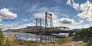
Hobart, Tasmania, Australia. The bridge's main function is to carry East Derwent Highway traffic, as well as pedestrians who travel between Bridgewater and...
1 KB (57 words) - 00:22, 30 April 2024
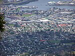
Glenorchy, Tasmania (category Populated places on the River Derwent)
the state of Tasmania, Australia. Glenorchy is bound by the River Derwent to the east, Mount Wellington to the west, Hobart City to the south and Brighton...
8 KB (779 words) - 11:15, 13 September 2024

Brighton Bypass (category Highways in Hobart)
2009, and was opened on 12 November 2012. From a roundabout at the East Derwent Highway in Bridgewater, the bypass heads north as a controlled-access route...
21 KB (1,847 words) - 00:36, 2 April 2024

River forms the western and north-western boundaries. Route B32 (East Derwent Highway) passes to the south. From there, Gage Road and Tottenham Road provide...
5 KB (320 words) - 17:03, 25 July 2024