
The East Side is a collection of neighborhoods in the eastern part of the city of Providence, Rhode Island. It officially comprises the neighborhoods of...
16 KB (1,512 words) - 21:18, 6 June 2024

Providence is the capital and most populous city of the U.S. state of Rhode Island. The county seat of Providence County, it is one of the oldest cities...
122 KB (10,553 words) - 08:34, 27 May 2024
New York Eastside, Oklahoma City, Oklahoma East Side, Pennsylvania East Side, Providence, Rhode Island, a collection of neighborhoods Eastside (King...
2 KB (259 words) - 15:55, 3 February 2024

70 km) in the US states of Rhode Island and Massachusetts. It travels from a junction with I-95 in Providence, Rhode Island, east to a junction with I-495...
36 KB (2,547 words) - 00:42, 27 April 2024

district of the city of Providence, Rhode Island, United States. It is bounded on the east by Canal Street and the Providence River, to the north by Smith...
22 KB (2,229 words) - 23:43, 28 October 2023

The South Side of Providence, Rhode Island, originally South Providence, is a term frequently used to describe the collective region comprising the official...
6 KB (693 words) - 13:52, 24 April 2022

Greenwich is the wealthiest municipality within the state of Rhode Island. It is part of the Providence metropolitan statistical area and the Greater Boston combined...
30 KB (2,482 words) - 13:00, 30 April 2024

Route 10 is a numbered state highway connector in the U.S. state of Rhode Island, traveling along the Huntington Expressway, the first freeway in the state...
17 KB (1,569 words) - 00:41, 20 March 2024

states of Rhode Island and Massachusetts. The highway runs 8.3 miles (13.4 km) from U.S. Route 44 (US 44) in North Providence, Rhode Island east through...
9 KB (681 words) - 20:28, 13 February 2024

Fox Point is a neighborhood in the East Side of Providence, Rhode Island. It is bounded by the Providence and Seekonk rivers, Interstate 195 and the College...
11 KB (1,001 words) - 15:36, 27 April 2024

the Seekonk River connecting India Point in Providence to Watchemoket Square in East Providence, Rhode Island. The historic portion of the bridge dating...
22 KB (2,233 words) - 00:53, 12 May 2024

Interstate Highway on the East Coast of the United States, running generally southwest–northeast through the US state of Rhode Island. It runs from the border...
22 KB (1,552 words) - 01:39, 25 March 2024

The city of Providence, Rhode Island has 25 official neighborhoods. Blackstone Charles College Hill Downtown Elmhurst Elmwood Federal Hill Fox Point Hartford...
5 KB (331 words) - 19:10, 22 August 2023

Massachusetts. In western Rhode Island, it forms part of one of several routes between Hartford, Connecticut, and Providence and was planned to be replaced...
28 KB (1,945 words) - 21:54, 20 March 2024

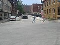
The East Side Railroad Tunnel is a former railroad tunnel that runs underneath the East Side of Providence, Rhode Island. The tunnel runs 5,080 feet (1...
12 KB (1,259 words) - 18:12, 3 March 2024
East Side Trolley Tunnel, also known as the East Side Transit Tunnel or the College Hill Tunnel,: 82 is a bi-directional tunnel in Providence, Rhode...
8 KB (679 words) - 18:33, 28 January 2024

and east; and the Atlantic Ocean to its south via Rhode Island Sound and Block Island Sound; and shares a small maritime border with New York, east of...
176 KB (15,401 words) - 23:00, 11 June 2024

Places in 1970. The current Rhode Island State House is Rhode Island's seventh state house and the second in Providence after the Old State House. The...
22 KB (1,979 words) - 00:48, 6 June 2024
the history of the city of Providence, Rhode Island, United States. 1635 – Great Colonial Hurricane of 1635 1636 – Providence founded by Roger Williams...
63 KB (5,825 words) - 17:11, 3 June 2024

residential town in Bristol County, Rhode Island, United States, approximately 7 miles (11 km) southeast of Providence. It was founded by Congregationalist...
44 KB (3,765 words) - 12:59, 30 April 2024

Route 14 is a numbered state highway in the U.S. state of Rhode Island. It runs approximately 23 miles (37 km) from Connecticut routes 14 and 14A at the...
6 KB (314 words) - 14:19, 30 April 2024

church at 300 Westminster Street at Mathewson Street in downtown Providence, Rhode Island. It was built in 1845–1846 and was designed by Richard Upjohn in...
8 KB (747 words) - 23:02, 2 June 2024

Blackstone is a predominantly residential neighborhood in Providence, Rhode Island. It is in the northeast corner of the city and is bounded to the south...
12 KB (1,242 words) - 17:20, 29 March 2023
co-educational independent school founded in 1923. Located in East Providence, Rhode Island, United States, it serves 375 students in grades PreK through 12...
9 KB (930 words) - 15:25, 20 February 2024
Elmwood is a neighborhood in the South Side of Providence, Rhode Island. The triangular region is demarcated by Broad Street, Elmwood Avenue, and Interstate...
15 KB (1,531 words) - 05:28, 6 August 2023
Hill is a historic neighborhood of Providence, Rhode Island, and one of six neighborhoods comprising the city's East Side. It is roughly bounded by South...
27 KB (2,367 words) - 21:18, 6 June 2024

RIPTA system is Kennedy Plaza, a large bus terminal in downtown Providence, Rhode Island. Average daily ridership as of the first quarter of 2024 is 40...
17 KB (800 words) - 11:57, 10 May 2024

the Providence Beltway, is an auxiliary Interstate Highway in the US states of Rhode Island and Massachusetts. It is maintained by the Rhode Island Department...
17 KB (1,186 words) - 18:34, 22 May 2024

neighborhood in Providence, Rhode Island bordered by Atwells Avenue to the north, U.S. Route 6 to the south and Rhode Island Route 10 to the east. The Woonasquatucket...
10 KB (1,010 words) - 22:52, 11 June 2024

Red Bridge) is a bridge in Rhode Island which spans the Seekonk River, and connects the East Side neighborhood of Providence with the Watchemoket and Phillipsdale...
15 KB (1,561 words) - 01:51, 6 March 2024