
The El Camino Real de los Tejas National Historic Trail is a national historic trail covering the U.S. section of El Camino Real de Los Tejas, a thoroughfare...
8 KB (835 words) - 21:31, 24 August 2024
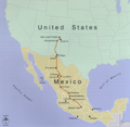
California Mission Trail El Camino Real de Los Tejas – El Camino Real from Texas east to Louisiana National Register of Historic Places listings in Socorro...
50 KB (4,625 words) - 20:35, 9 August 2024
de Alcalá in San Diego and the other one near Mission San Francisco de Asís in San Francisco. California Roads portal El Camino Real de los Tejas El Camino...
27 KB (2,402 words) - 21:46, 19 August 2024
site of Los Adaes was declared a National Historic Landmark in 1986. It is a site on the El Camino Real de los Tejas National Historic Trail. Today the...
17 KB (1,865 words) - 02:09, 2 July 2024

Chilkoot Trail - Klondike Gold Rush National Historical Park". National Park Service. Retrieved December 28, 2022. "El Camino Real de los Tejas National Historic...
60 KB (2,726 words) - 20:04, 14 July 2024
Old San Antonio Road (category Historic trails and roads in Texas)
The Old San Antonio Road is considered a part of El Camino Real de los Tejas National Historic Trail. Louisiana Highway 6 mostly runs alongside the Old...
9 KB (1,029 words) - 15:59, 23 July 2024

mid-to-late 19th century. The park is part of the El Camino Real de los Tejas National Historic Trail. During the Cretaceous Period through the early Paleogene...
11 KB (1,329 words) - 02:56, 28 May 2024

Hasinai (redirect from Tejas tribe)
Mississippian culture Caddo Caddo language Yowani Choctaw El Camino Real de los Tejas National Historic Trail 2011 Oklahoma Indian Nations Pocket Pictorial Directory...
6 KB (513 words) - 14:21, 15 July 2024

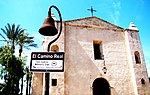
established in 1721. The site is located on the original El Camino Real de los Tejas trail. The site has no above ground remains of the mission but the...
7 KB (799 words) - 08:29, 24 August 2024
National Cemetery El Camino Real de los Tejas National Historic Trail Jean Lafitte National Historical Park and Preserve New Orleans Jazz National Historical...
34 KB (657 words) - 19:48, 12 August 2024

the trail served as a vital commercial highway until 1880, when the railroad arrived in Santa Fe. Santa Fe was near the end of El Camino Real de Tierra...
33 KB (3,736 words) - 16:16, 3 August 2024

mound. Located on a precontact Native American trail later named by the Spanish as El Camino Real de los Tejas, the settlement developed hundreds of years...
12 KB (1,201 words) - 16:15, 7 December 2023

the El Camino Real de los Tejas Visitors Center. Goliad area historic sites include: Reconstructed Mission Nuestra Señora del Espíritu Santo de Zúñiga;...
5 KB (259 words) - 01:35, 23 November 2023

Fort in Historic Nacogdoches". Pictures of Historic Nacogdoches. Retrieved 2012-02-16. "El Camino Real de los Tejas National Historic Trail: Historical...
19 KB (2,464 words) - 04:21, 8 August 2024

the summit of Guadalupe Peak, with views of El Capitan and the Chihuahuan Desert. The McKittrick Canyon trail leads to a stone cabin built in the early...
22 KB (1,874 words) - 00:42, 11 August 2024
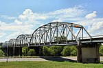
Montopolis Bridge (category National Register of Historic Places in Austin, Texas)
Colorado River in the area with the historic crossing of the El Camino Real de los Tejas National Historic Trail just to the east. On June 15, 1935, the...
7 KB (439 words) - 01:16, 23 July 2024

Staff (June 2011). "National Historic Landmarks Survey: List of National Historic Landmarks by State (Texas)" (PDF). National Park Service. Retrieved...
14 KB (1,191 words) - 16:48, 29 March 2024

San Francisco de la Espada was established in 1690 as San Francisco de los Tejas near present-day Augusta. and renamed San Francisco de los Neches in 1721...
12 KB (1,055 words) - 17:31, 1 August 2023

Washington-on-the-Brazos State Historic Site. Washington-on-the-Brazos State Historic Site Barrington Plantation State Historic Site Washington-on-the-Brazos...
12 KB (932 words) - 16:46, 16 August 2024

Oregon Trail. Wikiquote has quotations related to Oregon Trail. Wikivoyage has a travel guide for Oregon Trail. Oregon National Historic Trail (National Park...
144 KB (19,253 words) - 07:09, 1 August 2024

Provencal resident. Provencal is near Isle Brevelle and El Camino Real de los Tejas National Historic Trail located at 31°39′15″N 93°12′4″W / 31.65417°N 93...
9 KB (538 words) - 21:37, 13 May 2024

Fort Davis National Historic Site is a United States National Historic Site located in the unincorporated community of Fort Davis, Jeff Davis County,...
10 KB (936 words) - 17:33, 15 October 2023
Dies, Jr. State Park McKinney Falls State Park Meridian State Park Mission Tejas State Park Monahans Sandhills State Park Mother Neff State Park Mustang...
31 KB (1,411 words) - 13:11, 5 August 2024

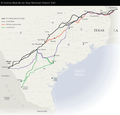
"Interactive Trail Maps". El Camino Real de los Tejas National Historic Trail Association. Accessed June 4, 2022. National Park Service, Montopolis Bridge, El Camino...
36 KB (4,384 words) - 21:22, 16 June 2024

Louisiana (redirect from État de Louisiane)
2021. "Early Caddo History – El Camino Real de los Tejas National Historic Trail (U.S. National Park Service)". National Park Service. Archived from the...
250 KB (22,577 words) - 07:10, 23 August 2024

Hueco Tanks (redirect from Hueco Tanks State Historic Site)
Hueco Tanks is an area of low mountains and historic site in El Paso County, Texas, in the United States. It is located in a high-altitude desert basin...
23 KB (2,636 words) - 07:12, 22 July 2024

New Mexico with those of Los Angeles, California and southern California. Approximately 700 mi (1,100 km) long, the trail ran through areas of high mountains...
32 KB (3,688 words) - 16:31, 23 April 2024

regions known as the Maderas del Carmen and the Cañón de Santa Elena. During the early historic period (before 1535) several Indian groups were recorded...
53 KB (4,946 words) - 14:22, 5 August 2024

Palo Duro Canyon (category National Natural Landmarks in Texas)
canyon is the Lighthouse Rock. A multiple-use, 6 mi (10 km) round-trip loop trail is dedicated to the formation. Palo Duro Canyon was downcut by the Prairie...
24 KB (2,618 words) - 23:14, 23 August 2024

will be developed with trails for hiking or biking, though this may be many years away. The El Paso Museum of Archeology and National Border Patrol Museum...
14 KB (1,185 words) - 13:34, 22 May 2024