
The flag of Roraima is one of the official symbols of the state of Roraima in Brazil. The flag was designed by Mário Barreto, and instituted by state law...
4 KB (355 words) - 19:29, 13 March 2024

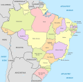
Roraima (Brazilian Portuguese: [ʁoˈɾajmɐ] or [ʁoˈɾɐ̃jmɐ]) is one of the 26 states of Brazil. Located in the country's North Region, it is the northernmost...
76 KB (7,765 words) - 08:11, 30 January 2025
Romania (1965–1989) Flag of Rondônia Flag of Roraima Flag of Russia Presidential Flag of Russia Flag of Rwanda Flag of Saint Lucia Flag of Saint Vincent and...
205 KB (10,883 words) - 19:27, 6 January 2025

flag of the Province of São Pedro do Rio Grande do Sul. Former flag of the Roraima Federal Territory (until 1990). Unofficial flag of the province of...
36 KB (599 words) - 23:42, 22 January 2025
The national flag of Brazil is a blue disc depicting a starry sky (which includes the Southern Cross) spanned by a curved band inscribed with the national...
43 KB (3,803 words) - 19:01, 6 January 2025

View; figuratively "Fairview") is the capital of the Brazilian state of Roraima. Situated on the western bank of the Branco River, the city lies 220 km (140 mi)...
27 KB (2,014 words) - 14:07, 15 January 2025
a list of flags of states, territories, former, and other geographic entities (plus a few non-geographic flags) sorted by their combinations of dominant...
175 KB (7,590 words) - 23:37, 14 January 2025
page lists the country subdivision flags in South America. It is a part of the Lists of country subdivision flags, which is split into continents due...
81 KB (1,920 words) - 04:26, 14 January 2025
This is a list of sovereign states by the date on which they adopted their current national flag. For most of these states, the date of flag adoption is...
38 KB (1,100 words) - 17:06, 31 January 2025
pronunciation: [iɾaˈsẽmɐ]) is a municipality located in the midwest of the state of Roraima in Brazil. Its population is 12,296 (2020) and its area is 14,413 km²...
3 KB (109 words) - 17:35, 19 October 2024
Flags of the world's nations vary in the number of colours, ranging from one colour to more than forty.[citation needed] Abbasid Caliphate (750–1258)...
69 KB (3,108 words) - 17:57, 24 November 2024

pronunciation: [bõˈfĩ]) is a municipality located in the mideast of the state of Roraima in Brazil. Its population is 12,557 and its area is 8,095 km2....
6 KB (340 words) - 17:26, 19 October 2024
The history of the territory that is now Roraima, a state at the extreme north of present-day Brazil is recent, but not thereby simple. Invaded numerous...
46 KB (5,691 words) - 08:17, 15 August 2024

[sɐ̃w luˈiz dwanɐˈwa]) is a municipality located in the southeast of the state of Roraima in Brazil. Its population is 7.315 and its area is 1,527 km2, which...
3 KB (129 words) - 17:41, 19 October 2024

northeastern region of the Brazilian state of Roraima. Normandia covers 6,960 km2 (2,690 sq mi), and has an estimated population of 11,532 as of 2020 with a population...
9 KB (649 words) - 17:30, 19 October 2024

(Portuguese pronunciation: [ˈawtu aˈlɛɡɾi]) is a city in the Brazilian state of Roraima. The population in 2020 was 15,380, and the area is 25,567 km². Its limits...
4 KB (151 words) - 17:21, 19 October 2024
of 1988 created the state of Tocantins from the northern portion of Goiás, established Amapá and Roraima as states, and returned the archipelago of Fernando...
31 KB (1,851 words) - 16:16, 28 January 2025
This is a list of all airline codes. The table lists the IATA airline designators, the ICAO airline designators and the airline call signs (telephony designator)...
3 KB (747 words) - 10:21, 7 January 2025

September 1907. In 1932, Juan Vicente Gómez agreed a point on the summit of Mount Roraima as the three-way boundary between Brazil, British Guiana and Venezuela...
20 KB (1,178 words) - 18:59, 25 October 2024

Roraima. POVOS ORIGINÁRIOS - Doze línguas indígenas são reconhecidas como patrimônio cultural imaterial de Roraima, Assembleia Legislativa de Roraima...
126 KB (9,844 words) - 16:14, 1 February 2025

Pará (redirect from State of Pará)
Tocantins, Mato Grosso, Amazonas and Roraima. To the northwest are the borders of Guyana and Suriname, to the northeast of Pará is the Atlantic Ocean. The...
42 KB (4,257 words) - 12:04, 27 January 2025

Guyana–Venezuela crisis (2023–present) (category Wikipedia articles in need of updating from May 2024)
moving its troops through Brazilian soil, in the state of Roraima. Military movements through Roraima would be significantly less hampered by the regional...
126 KB (11,640 words) - 13:51, 31 January 2025
The following is a list of regional airlines organized by home country. List of airlines List of low-cost airlines Flag carrier...
12 KB (22 words) - 04:34, 27 January 2025

Pacaraima (category Municipalities in Roraima)
pronunciation: [pakaˈɾajmɐ]) is a municipality located in the northwest of the state of Roraima in Brazil. It is second most northern municipality in Brazil, behind...
8 KB (649 words) - 09:47, 29 November 2024
official flag is the French flag. Only the French flag is officially recognized by the French constitution as the national flag, the green and yellow flag is...
122 KB (721 words) - 23:18, 26 January 2025

Uiramutã (category Municipalities in Roraima)
northeast of the state of Roraima in Brazil. Its population is 10,789 (as of 2020) and its area is 8,066 km2. It is the northernmost municipality of Brazil...
6 KB (396 words) - 17:32, 19 October 2024

Amazonas (Brazilian state) (redirect from Climate of Amazonas)
clockwise) Roraima, Pará, Mato Grosso, Rondônia, and Acre. It also borders the nations of Peru, Colombia and Venezuela. This includes the Departments of Amazonas...
62 KB (6,660 words) - 12:52, 1 February 2025

Cantá (category Municipalities in Roraima)
located in the mideast of the state of Roraima in Brazil. Its population is 18,799 (2020) and its area is 7,665 km². The municipality of Cantá was established...
5 KB (239 words) - 17:27, 19 October 2024

Amajari (category Municipalities in Roraima)
northwest of the state of Roraima in Brazil. Its population is 13,185 and its area is 28,472 km². It is the westernmost municipality in Roraima. The municipality...
4 KB (246 words) - 17:23, 19 October 2024
Brazil (redirect from Republic of Brazil)
the last three: Amapá and Roraima (which gained statehood status) and Fernando de Noronha, which became a state district of Pernambuco. Brazil is a developing...
288 KB (25,754 words) - 21:57, 1 February 2025