
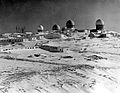
coordinates) Fort Yukon Long Range Radar Site is a radar site of the United States Air Force. It is located 1.6 miles (2.6 km) east-southeast of Fort Yukon, Alaska...
7 KB (883 words) - 13:42, 2 November 2022

Pacific Air Forces Regional Support Center (redirect from Alaska Radar System)
operation, and quality assurance of the Alaska Radar System, consisting of 17 long-range and 3 short-range radar sites; the forward operation locations at Galena...
8 KB (759 words) - 15:19, 13 July 2024
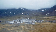
Murphy Dome Air Force Station (redirect from Murphy Dome Long Range Radar Site)
on 1 November 1983, and was re-designated as a Long Range Radar (LRR) site as part of the Alaska Radar System. Today[when?], it remains active as part...
9 KB (1,276 words) - 00:58, 23 June 2024

Barter Island LRRS Airport (redirect from Barter Island Long Range Radar Site)
Airport or Kaktovik Airport. The acronym LRRS stands for Long Range Radar Site or Long Range Radar Station. Barter Island LRRS Airport has one runway designed...
12 KB (881 words) - 20:53, 13 December 2023

North Warning System (redirect from Komakuk Beach SRR Site)
DYE radar stations. Motorola AN/FPS-23 short range search radar was installed at the Intermediate sites, used as fillers to cover any Long Range Radar surveillance...
55 KB (1,060 words) - 19:24, 18 July 2024
Point Lay LRRS Airport (redirect from Point Lay Long Range Radar Site)
known as Point Lay Airport. The acronym LRRS stands for Long Range Radar Site or Long Range Radar Station. Point Lay LRRS Airport has one runway designated...
5 KB (410 words) - 16:40, 16 August 2024
Canadian Indian residential school gravesites (category CS1: long volume value)
former site of Fort Alexander Indian Residential School, near Powerview-Pine Falls in Manitoba, using drone surveying and ground-penetrating radar. On June...
125 KB (11,915 words) - 00:13, 3 October 2024

HMCS Yukon was a Mackenzie-class destroyer that served in the Royal Canadian Navy (RCN) and later the Canadian Forces. She was the first Canadian naval...
14 KB (1,504 words) - 23:58, 10 August 2024

Cape Spear (redirect from Cape Spear Lighthouse National Historic Site)
the Atlantic Ocean. It was closed in 1945. The site was established in 1942 as a United States Ground Radar Early Warning Station, funded by the United States...
16 KB (1,509 words) - 05:42, 26 July 2024

Bethel AFS, Fort Yukon AFS, Unalakleet AFS and Kotzebue AFS. The additional sites were all operational by July 1958. In addition to the radar sites, landing...
69 KB (7,628 words) - 04:19, 20 August 2024

Chevrolet Suburban (redirect from GMC Yukon XL)
Car & Driver (September 27, 2021) "Site Maintenance". "2021 GMC Yukon XL" from CarBuzz (March 17, 2020) 2021 "GMC Yukon Denali adds another extra-luxe accessories...
169 KB (16,946 words) - 19:12, 30 August 2024

117 drilling rig site, the complete destruction of other buildings in the rig's vicinity, tossed vehicles, and the mobile Doppler radar data.: 7 In the...
46 KB (4,742 words) - 17:57, 16 September 2024
Both sites were demolished before 1987. In addition to the Aleutian Island extension, Project Bluegrass also included a 50 kW shot from Fort Yukon to Barter...
12 KB (497 words) - 13:26, 17 January 2024

the Fort Wainwright yard, which is not far from the site where the VC-22 sits abandoned. Today, the LCC-1 now has a permanent site at the Yukon Transportation...
14 KB (2,009 words) - 18:28, 22 March 2024

Wainwright Airport (Alaska) (redirect from Wainwright Short Range Radar Site)
The radar station was upgraded in the late 1980s with new radars and in 1989 was re-designated part of the North Warning System (NWS) as a Long Range Radar...
7 KB (560 words) - 21:40, 26 August 2024

Naval Air Station Jacksonville (category Military Superfund sites)
Landing Field Whitehouse, and the Pinecastle Range Complex. It also neighbors a small ghost town called Yukon. During World War I, the area now occupied...
24 KB (2,536 words) - 13:11, 23 September 2024

and stationed at Ladd Air Force Base, Alaska. It was established as the Yukon Composite Wing on 15 June 1948, and then redesignated as the 5001st Composite...
16 KB (2,296 words) - 13:52, 3 September 2024
capability. The radar changes frequencies more than 1,000 times per second to lower interception probability and has an estimated range of 125–150 mi (201–241 km)...
192 KB (19,322 words) - 22:23, 2 October 2024

Prince George, British Columbia (redirect from Fort George, British Columbia)
The original radar system has been removed and the location now operates a weather station and Nav Canada system. In 1953, (Central) Fort George Townsite...
98 KB (10,833 words) - 18:15, 1 October 2024
Indian Mountain LRRS Airport (category Airports in the Yukon–Koyukuk Census Area, Alaska)
airstrip. Its mission is to provide access to the Indian Mountain Long Range Radar Station for servicing and other requirements. The airstrip was constructed...
3 KB (283 words) - 21:59, 25 June 2021
Tatalina LRRS Airport (category Airports in the Yukon–Koyukuk Census Area, Alaska)
military airstrip. Its mission is to provide access to the Tatalina Long Range Radar Site for servicing and other requirements. The airstrip was constructed...
3 KB (304 words) - 06:06, 19 September 2024
– South Naknek, Alaska PFYU (FYU) – Fort Yukon Airport – Fort Yukon, Alaska POLI – Oliktok Long Range Radar Site (closed) – Oliktok Point, Alaska PPDM...
26 KB (2,341 words) - 16:38, 21 January 2024

HMS Prince of Wales (53) (category Wreck diving sites)
extreme range of 30,300 yards (27,700 m). All 12 salvos missed. At 01:00 on 25 May Prince of Wales again regained contact and opened fire at a radar range of...
49 KB (5,812 words) - 22:04, 31 August 2024
Acquisition Radar Attack Characterization System". Air Force Space Command (Archived).[permanent dead link] "Long Range Discrimination Radar (LRDR), Clear...
212 KB (17,771 words) - 04:35, 22 September 2024

emergency for Custer City, Oklahoma while another EF2 tornado passed near Yukon. On May 21, the Storm Prediction Center issued a Moderate risk for severe...
176 KB (15,557 words) - 14:14, 2 October 2024

SS Andrea Doria (category Wreck diving sites)
misinterpreted radar data and badly overestimated the distance between the two ships. The poor design of the radar settings, coupled with unlighted range settings...
89 KB (12,068 words) - 19:55, 25 September 2024
(secondary coordinates) Cape Air Force Base also known as Fort Glenn Army Air Base, is a site significant for its role in World War II fighting, operating...
16 KB (1,840 words) - 11:23, 10 February 2024

The range of GEE was 300–400 mi (480–640 km). GEE used a whip aerial mounted on the top of the fuselage ahead of the mid-upper turret. Boozer (radar detector)...
123 KB (15,240 words) - 16:58, 1 October 2024

Kamloops (redirect from Fort Kamloops)
by ground penetrating radar at the site of the school. The remains were located with the assistance of ground-penetrating radar, and work was underway...
96 KB (8,349 words) - 00:21, 25 August 2024

was an attack helicopter armed with long-range BGM-71 TOW missiles able to destroy tanks from outside the range of defensive fire. The helicopter was...
129 KB (13,842 words) - 18:48, 24 September 2024