
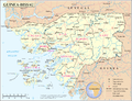
167°N 14.167°W / 12.167; -14.167 Gabú region is the easternmost region in Guinea-Bissau. Its capital is Gabú. The region borders Senegal to the north, Guinea...
12 KB (1,181 words) - 10:10, 1 February 2025

Gabú is the largest city in eastern Guinea-Bissau, the second most populated city in Guinea-Bissau and capital of the Gabú region. Founded under the name...
9 KB (487 words) - 10:14, 1 February 2025
Gabu or Gabú may refer to: Gabú region of Guinea-Bissau Gabú, a town and capital of Gabú region, Guinea-Bissau Gabu, Nigeria Gat Andrés Bonifacio University...
266 bytes (63 words) - 10:15, 1 February 2025

Sectors of Guinea-Bissau (section Gabú region)
Here are the following listed below, by region: Bafata Bambadinca Contuboel Galomaro Gamamundo Xitole Boe Gabú Piche Pirada Sonaco Prabis Quinhamel Safim...
3 KB (94 words) - 22:56, 2 February 2025
Lamego Airport (IATA: GGGB) is an airport serving the city of Gabú, the capital of the Gabú Region of Guinea-Bissau. List of airports in Guinea-Bissau Transport...
1 KB (47 words) - 20:42, 8 October 2024
Boe, Guinea-Bissau (category Gabu region)
Boe (full name Madina do Boe) is a settlement in the southeastern Gabú Region of Guinea-Bissau. The population is mostly of poor Fulani speaking herders...
6 KB (239 words) - 22:31, 2 January 2025
refer to: Tagelmust, indigo-dyed cotton garment Chéché, village in the Gabú Region of north-eastern Guinea-Bissau Action sociale CHECHE, an organization...
426 bytes (78 words) - 20:13, 15 May 2020
of the Guinean village of Sofan, Gabú Region Southernmost point – unnamed headland on Ilha Cataque, Tombali Region Westernmost point - Cape Roxo at the...
11 KB (917 words) - 07:02, 9 November 2024
: 6 The Kaabu Mansaba was seated in Kansala, today known as Gabu, in the eastern Gabú region.: 4 The slave trade dominated the economy, and the warrior...
98 KB (9,011 words) - 19:14, 27 February 2025
Utena County 230 755 184 Guinea-Bissau Bolabá Gabú Region 226 744 185 Belarus Lahojsk Minsk Region 220 725 186 Latvia Alūksne Vidzeme 217 712 List...
34 KB (533 words) - 20:09, 9 February 2025
Piche, Guinea-Bissau (category Gabu region)
Piche is a Sector in the Gabú Region of Guinea-Bissau. Piché is also a common last name. 12°20′N 13°57′W / 12.333°N 13.950°W / 12.333; -13.950 v t...
383 bytes (37 words) - 22:31, 2 January 2025
Mali, Tambacounda Region 11°22′W 158 Iceland Hvalbakur, Suður-Múlasýsla 13°14′W 159 Guinea-Bissau Border with Guinea, Gabú Region 13°40′W 160 Gambia...
28 KB (186 words) - 09:29, 25 June 2024

ethnic group in Sahara, Sahel and West Africa, widely dispersed across the region. Inhabiting many countries, they live mainly in West Africa and northern...
129 KB (13,285 words) - 21:57, 18 February 2025
agricultural and agro-allied industrial potentials. A large part of the Gabu region consists of grassland or savanna and rainforest in places such as Ega...
4 KB (453 words) - 07:45, 13 May 2024
Uelíngarà (category Gabu region)
Uelíngarà is a village in the Gabú Region of north-eastern Guinea-Bissau. It lies to the south of Gabú and north of Canjadude. Google Maps (Map). Google...
2 KB (41 words) - 22:31, 2 January 2025
elevation of 266 metres (873 ft). The hill is located in the administrative region Gabú, near the southern border with Guinea. It is named after the British...
2 KB (88 words) - 21:36, 1 February 2025

Canjadude (category Gabu region)
Canjadude is a village in the Gabú sector of the Gabú Region in north-eastern Guinea-Bissau. It lies to the south of Uelíngarà.[citation needed] Canjadude...
2 KB (63 words) - 22:31, 2 January 2025

Buruntuma (category Gabu region)
Buruntuma is a village in the Gabú Region of north-eastern Guinea-Bissau. It lies on the border with Guinea, to the southeast of Canquelifá.[citation...
2 KB (83 words) - 22:31, 2 January 2025
Cansisse (category Gabu region)
Cansisse is a village located in the Gabú Region of central-eastern Guinea-Bissau. It lies to the south of Canjia.[citation needed] Maplandia World Gazetteer...
2 KB (29 words) - 22:31, 2 January 2025

Umaro Djau (1967–), international journalist and politician. Born in Gabú region Kimi Djabate (1975–), Afro-beat musician. Born in Tabato. Fausto Duarte...
5 KB (615 words) - 05:27, 2 February 2025
Camajábà (category Gabu region)
Camajábà is a village in the Gabú Region of north-eastern Guinea-Bissau. It lies to the southwest of Buruntuma and west of Piche.[citation needed] Maplandia...
2 KB (32 words) - 22:31, 2 January 2025
Lenquete (category Gabu region)
Lenquete is a village in the Gabú Region of central-eastern Guinea-Bissau. It lies to the northwest of Gabú. Google Maps (Map). Google. Bing Maps (Map)...
2 KB (40 words) - 22:31, 2 January 2025
Carantaba (category Gabu region)
Carantaba is a village in the Gabú Region of north-eastern Guinea-Bissau. It lies to the northwest of Piche and northeast of Gabú.[citation needed] Maplandia...
2 KB (32 words) - 22:31, 2 January 2025
Pirada (category Gabu region)
Pirada is a Sector in the Gabú Region of Guinea-Bissau. It is a town and an administrative division (sector) in the northeast area of Guinea-Bissau with...
927 bytes (99 words) - 22:31, 2 January 2025
Cã Mamudo (category Gabu region)
Cã Mamudo is a village in the Gabú Region of central-eastern Guinea-Bissau. It lies to the west of Lenquete and southeast of Sonaco.[citation needed]...
2 KB (33 words) - 22:31, 2 January 2025
first publication of ISO 3166-2 in 1998: Subdivisions of Guinea-Bissau FIPS region codes of Guinea-Bissau Neighbouring countries: GN, SN ISO Online Browsing...
4 KB (231 words) - 03:19, 31 January 2024
Chéché (category Gabu region)
Chéché or Ché Ché is a village in the Gabú Region of north-eastern Guinea-Bissau. It lies on the south of the Corubal River, to the south of Canjadude...
2 KB (82 words) - 22:31, 2 January 2025
Sonaco is a town and sector in the Gabú Region of Guinea-Bissau. 12°24′N 14°29′W / 12.400°N 14.483°W / 12.400; -14.483 v t e...
333 bytes (32 words) - 22:51, 9 March 2021
of FIPS region codes (A-C) List of FIPS region codes (D-F) List of FIPS region codes (G-I) List of FIPS region codes (J-L) List of FIPS region codes (M-O)...
23 KB (151 words) - 10:42, 18 April 2024
Regional de Gabu Gabú region Regional Hospital 12°16′45″N 14°13′14″W / 12.2791°N 14.2206°W / 12.2791; -14.2206 (Hospital Regional de Gabu) Hospital Regional...
3 KB (90 words) - 21:40, 1 February 2025