Guam Highway 27 (GH-27), also known as Hamburger Highway or Harmon Loop Road, is a short highway in the United States territory of Guam. The highway runs...
4 KB (292 words) - 09:08, 26 August 2024
Washington State Route 27 West Virginia Route 27 Wisconsin Highway 27 Territories Guam Highway 27 Puerto Rico Highway 27 List of highways numbered 27A This...
9 KB (669 words) - 10:27, 27 August 2024

Guam Highway 1 (GH-1), also known as Marine Corps Drive, is one of the primary automobile routes in the United States territory of Guam. It runs in a...
11 KB (938 words) - 04:21, 10 June 2022
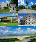
the capital of the United States territory of Guam. From the 18th through mid-20th century, it was Guam's population center, but today, it is the second...
22 KB (1,704 words) - 13:44, 22 September 2024

Guam (/ˈɡwɑːm/ GWAHM; Chamorro: Guåhan [ˈɡʷɑhɑn]) is an organized, unincorporated territory of the United States in the Micronesia subregion of the western...
108 KB (10,055 words) - 16:39, 3 October 2024
Guam Highway 16 (GH-16), also named Army Drive, is one of the primary automobile highways in the United States territory of Guam . GH-16 serves as one...
3 KB (196 words) - 09:08, 26 August 2024
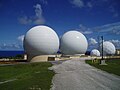
Finegayan Telecommunications Site along Guam Highway 3 in Dededo, on the northwest coast of the island. NCTS Guam is under the United States Tenth Fleet's...
7 KB (520 words) - 08:10, 22 September 2023
Highways in Guam are maintained by the Department of Public Works in the United States territory of Guam. U.S. Roads portal Staff. "Part 2a: History"....
14 KB (115 words) - 21:26, 3 March 2024

Andersen Air Force Base (redirect from North Field, Guam)
located primarily within the village of Yigo in the United States territory of Guam. The host unit at Andersen AFB is the 36th Wing (36 WG), assigned to the...
45 KB (4,542 words) - 17:17, 15 September 2024

(1,001 ft)) and Mount Chacao (309 metres (1,014 ft)), borders Yona. Guam Highway 1, known as Marine Corps Drive, runs along the mainland coastline of...
11 KB (1,219 words) - 15:57, 8 July 2023

Guam is an island territory of the United States, located in the Northwest Pacific Ocean, and is part of the Mariana Islands. Guam lies in the path of...
89 KB (8,843 words) - 20:58, 29 August 2024
early 1940s) Vermont Route 2A Territories Guam Highway 2A This article includes a list of roads, streets, highways, or other routes that are associated with...
927 bytes (105 words) - 15:54, 26 June 2024

Typhoon Mawar (category 2023 in Guam)
Typhoon Pongsona in 2002. U.S. President Joe Biden declared Guam a major disaster area on May 27, enabling the distribution of federal funds. Two men are...
77 KB (6,686 words) - 18:58, 16 September 2024

living north of Guam Highway 4 are zoned to Andersen Elementary and Andersen Middle School, while people living south of Guam Highway 4 are zoned to McCool...
9 KB (766 words) - 02:21, 2 October 2024
1 (former) Secondary State Highway 1A (Washington) (former) Routes in other areas American Samoa Highway 001 Guam Highway 1 Interstate PRI-1 (Puerto Rico;...
20 KB (1,282 words) - 08:59, 27 August 2024
Guam Islands of Guam Lakes of Guam Mountains of Guam Volcanoes in Guam Rivers of Guam Waterfalls of Guam Valleys of Guam World Heritage Sites in Guam:...
15 KB (1,355 words) - 11:40, 7 January 2024
Republican Party of Guam, commonly referred to as Guam GOP (abbreviation for Guam Grand Old Party), is a political party in Guam affiliated with the United...
29 KB (3,456 words) - 20:17, 7 September 2024

the U.S. Virgin Islands have a maximum speed limit of 55 mph (89 km/h). Guam and the Northern Mariana Islands have speed limits of 45 mph (72 km/h). American...
68 KB (4,404 words) - 19:23, 12 September 2024

Analysis (BEA) collects GDP data for four U.S. territories (American Samoa, Guam, the Northern Mariana Islands, and the U.S. Virgin Islands) separately from...
18 KB (716 words) - 18:42, 29 September 2024

enforcement laws. Thirty-four states, the District of Columbia, American Samoa, Guam, the Northern Mariana Islands, Puerto Rico and the U.S. Virgin Islands have...
23 KB (1,645 words) - 01:04, 26 September 2024

five permanently inhabited territories of the United States: Puerto Rico, Guam, the U.S. Virgin Islands, American Samoa, and the Northern Mariana Islands...
48 KB (1,323 words) - 11:24, 3 September 2024

shoreline, in particular the 1944 Liberation of Guam's Asan Invasion Beach. It is located largely along Guam Highway 6, known as Halsey Drive as it passes through...
7 KB (546 words) - 06:04, 25 May 2024

carry a weapon. He was twice awarded the Bronze Star Medal for actions on Guam and in the Philippines. Doss further distinguished himself in the Battle...
39 KB (3,335 words) - 13:14, 4 September 2024

Typhoon Bebinca (2024) (category 2024 in Guam)
Tropical Storm Ferdie, was a strong tropical cyclone that affected East China, Guam, Philippines and the Ryukyu Islands in early September 2024. Bebinca made...
37 KB (3,676 words) - 11:51, 3 October 2024

Micronesia Mall (category Shopping malls in Guam)
Dededo, Guam. Located at the intersection of Guam highways 1 and 16, it is the largest shopping center in the United States territory of Guam with over...
4 KB (381 words) - 20:40, 17 June 2024
Primary State Highway 17 (Washington) (former) West Virginia Route 17 Wisconsin Highway 17 Territories Guam Highway 17 Puerto Rico Highway 17 List of A17...
10 KB (732 words) - 15:45, 27 August 2024
Primary State Highway 10 (Washington) (former) West Virginia Route 10 Wisconsin Highway 10 (former) Wyoming Highway 10 Territories Guam Highway 10 Puerto...
11 KB (725 words) - 00:39, 15 September 2024

Typhoon Koinu (category 2023 in Guam)
then made landfall over Hengchun, Taiwan. On September 27, a low-pressure area formed near Guam, with the JTWC indicating the potential development of...
12 KB (1,244 words) - 19:29, 16 September 2024
Washington State Highway 6 (former) West Virginia Route 6 Territories American Samoa Highway 006 Guam Highway 6 Puerto Rico Highway 6 Route 6 Joaquín...
12 KB (814 words) - 09:06, 27 August 2024

Liberation Day on the U.S. territory of Guam is an annual commemoration of the invasion by U.S. military forces on July 21, 1944, which ended the Japanese...
25 KB (2,592 words) - 00:18, 3 August 2024