
the village of Hatteras is Hatteras Inlet which separates Hatteras Island from the neighboring Ocracoke Island. North Carolina Highway 12 passes through...
13 KB (909 words) - 05:10, 16 July 2024
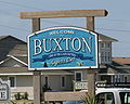
Cape Hatteras. It is part of North Carolina's Outer Banks and includes the communities of Rodanthe, Waves, Salvo, Avon, Buxton, Frisco, and Hatteras. It...
17 KB (1,469 words) - 21:30, 6 September 2024

Cape Hatteras /ˈhætərəs/ is a cape located at a pronounced bend in Hatteras Island, one of the barrier islands of North Carolina. As a temperate barrier...
22 KB (1,953 words) - 05:17, 16 September 2024

place (CDP) located in Dare County, North Carolina, United States, on Hatteras Island, part of North Carolina's Outer Banks. As of the 2020 census it...
18 KB (1,229 words) - 22:44, 25 September 2024

Hatteras Light is a lighthouse located on Hatteras Island in the Outer Banks in the town of Buxton, North Carolina and is part of the Cape Hatteras National...
17 KB (2,213 words) - 05:24, 16 September 2024
place (CDP) on Hatteras Island (part of the Outer Banks) near Cape Hatteras. It is located in Dare County in the U.S. state of North Carolina. As of the 2020...
15 KB (871 words) - 22:54, 25 September 2024

Cape Hatteras National Seashore is a United States national seashore which preserves the portion of the Outer Banks of North Carolina from Bodie Island...
16 KB (1,383 words) - 13:44, 30 August 2024
Banks. They inhabited a village on what is now called Hatteras Island called Croatoan. The name Hatteras was first used by the English explorer John Lawson...
4 KB (341 words) - 02:22, 17 May 2023
Hatteras may refer to: The Adventures of Captain Hatteras, the novel by Jules Verne Hatteras Networks, a North Carolina-based telecommunications equipment...
1 KB (145 words) - 12:56, 11 May 2019

the barrier island of Hatteras Island, between the villages of Buxton and Hatteras. It is located in Dare County, North Carolina, United States, and was...
12 KB (670 words) - 23:05, 25 September 2024

road across the island is part of North Carolina Highway 12, which uses a series of ferries to connect to Hatteras Island, to Cedar Island, and to the...
44 KB (3,817 words) - 13:01, 4 September 2024

Outer Banks (redirect from Outer Banks, North Carolina)
has, at times, been contiguous with neighboring Bodie Island or Hatteras Island), Hatteras Island, Ocracoke Island, Portsmouth Island, and the Core Banks...
31 KB (3,304 words) - 17:58, 7 September 2024

zoned to Dare County Schools. Zoned schools are Cape Hatteras Elementary School and Cape Hatteras Secondary School. "ArcGIS REST Services Directory". United...
14 KB (755 words) - 00:52, 26 September 2024

Alligator River Atlantic Ocean (North Atlantic Ocean) Broad Creek Croatan Sound Currituck Sound East Lake Hatteras Bight Hatteras Inlet Intracoastal Waterway...
24 KB (1,708 words) - 17:56, 11 August 2024

census-designated place (CDP) in Dare County, North Carolina, United States. It is on Hatteras Island, part of North Carolina's Outer Banks. As of the 2010 census...
12 KB (680 words) - 06:19, 14 July 2023

enters the Cape Hatteras National Seashore. NC 12 runs along the middle of the island all the way until it reaches the Cape Hatteras-Ocracoke ferry in...
22 KB (2,198 words) - 01:19, 5 August 2024
Diamond Shoals (category Eastern North Carolina geography stubs)
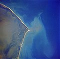
underwater sandbars that extend eight miles (13 km) out from Cape Hatteras, North Carolina, United States. Hidden beneath the waves and constantly changing...
2 KB (167 words) - 03:43, 2 July 2023

Carroll A. Deering (category Missing person cases in North Carolina)
launched in 1919 and found run aground without its crew off Cape Hatteras, North Carolina, in January 1921.[better source needed] The Carroll A. Deering...
22 KB (2,616 words) - 03:39, 16 April 2024

domination of the strategically important North Carolina Sounds. Two forts on the Outer Banks, Fort Clark and Fort Hatteras, had been built by the Confederates...
24 KB (3,115 words) - 13:46, 28 August 2023

census-designated place located in Dare County, North Carolina, United States, on Hatteras Island, part of North Carolina's Outer Banks. As of the 2010 census, Salvo...
13 KB (721 words) - 17:48, 20 September 2022

Hatteras Inlet is an estuary in North Carolina, located along the Outer Banks, separating Hatteras Island and Ocracoke Island. It connects the Atlantic...
3 KB (312 words) - 13:21, 25 April 2024

North Carolina (/ˌkærəˈlaɪnə/ KARR-ə-LY-nə) is a state in the Southeastern region of the United States. It is bordered by Virginia to the north, the Atlantic...
231 KB (20,214 words) - 04:30, 28 September 2024

rain, Florence remains as North Carolina's wettest hurricane. In 2019, Category 2 Hurricane Dorian made landfall on Cape Hatteras, causing large storm surges...
18 KB (1,845 words) - 22:59, 21 September 2024
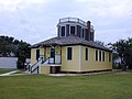
The Hatteras Weather Bureau Station is a wood-frame building in Hatteras, North Carolina built in 1901 for what was then called the U.S. Weather Bureau...
3 KB (231 words) - 21:48, 29 March 2021

Graveyard of the Atlantic Museum (category Hatteras Island)
Outer Banks of North Carolina. The museum is located in Hatteras Village, the southernmost community on Hatteras Island, North Carolina, and opened in...
3 KB (305 words) - 17:19, 17 May 2024

759 km (1,093 mi) north of Havana, Cuba and north-northeast of San Juan, Puerto Rico. The nearest landmass is Cape Hatteras, North Carolina, about 1,030 km...
32 KB (3,241 words) - 15:42, 19 September 2024

off the North Carolina coast. The signal of the Arapahoe was received by the United Wireless Telegraph Company station at Hatteras, North Carolina, and forwarded...
21 KB (2,378 words) - 22:16, 11 July 2024
Diamond Shoals, near Cape Hatteras, North Carolina. 1925: December 1, SS Cotopaxi, having departed Charleston, South Carolina two days earlier bound for...
15 KB (1,749 words) - 04:02, 29 July 2024

S. state of North Carolina. As of the 2020 census, the population was 4,589, making it the second-least populous county in North Carolina. Its county...
30 KB (2,591 words) - 17:56, 11 August 2024

Overseas Territory in the North Atlantic Ocean. It is approximately 1,070 km (665 mi) east-southeast of Cape Hatteras, North Carolina; 1,236 km (768 mi) south...
7 KB (233 words) - 23:38, 19 March 2023