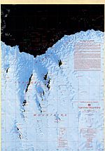
Holme Bay is a bay in Antarctica in Mac. Robertson Land, 22 miles (35 km) wide, containing many islands, indenting the coast 5 miles (8 km) north of the...
3 KB (237 words) - 14:59, 7 July 2024
(approx. 950 km2 (370 sq mi)), between Wilkes Land and Queen Mary Land Holme Bay, Mac. Robertson Land Vestfold Hills (approx. 420 km2 (160 sq mi)), Princess...
4 KB (338 words) - 20:00, 29 April 2024
Holme Bay and northeast of the Masson Range. Mount Henderson is a massive mountain rising through the ice sheet 5 miles (8.0 km) southeast of Holme Bay...
10 KB (894 words) - 14:59, 7 July 2024
Look up holme in Wiktionary, the free dictionary. Holme may refer to: Holme (surname) Holme (band) Holme Bay Holme, Aarhus Holme, Bedfordshire Holme, Cambridgeshire...
1 KB (145 words) - 21:20, 16 December 2020

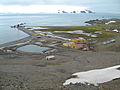
Antarctica managed by the Australian Antarctic Division (AAD). Mawson lies in Holme Bay in Mac. Robertson Land, East Antarctica in the Australian Antarctic Territory...
21 KB (1,587 words) - 01:26, 9 June 2024
Flat Islands (redirect from Flat Islands (Holme Bay))
Islands (Antarctica) Flat Islands, Bonavista Bay, Newfoundland and Labrador Flat Islands, Placentia Bay, Newfoundland and Labrador Flat Island (disambiguation)...
294 bytes (64 words) - 13:03, 19 October 2013
is an isolated rock lying between Nøst Island and the Flat Islands in Holme Bay, Mac. Robertson Land. It was mapped by Norwegian cartographers from air...
1 KB (91 words) - 21:22, 21 September 2024
600; 62.867) is a small island between Lee Island and Entrance Island in Holme Bay, Mac. Robertson Land. Plotted from photos taken by ANARE (Australian National...
610 bytes (94 words) - 00:56, 22 July 2024
Shoal, almost circular shoal lying just north of East Budd Island in Holme Bay Carsten (disambiguation) Karstens (disambiguation) This disambiguation...
364 bytes (72 words) - 08:37, 9 August 2021
Island is the most northern of the Rookery Islands in the west part of Holme Bay, MacRobertson Land. Mapped by Norwegian cartographers from air photos...
2 KB (86 words) - 13:24, 4 June 2024

the bridge was converted to road use in 1979. To the east of Lady Bay is the Holme Pierrepont National Watersports Centre. To the south, beyond the Grantham...
7 KB (623 words) - 21:32, 17 November 2023
the largest of the Flat Islands, located just west of Stinear Island in Holme Bay, Mac. Robertson Land. It is one of several plotted as a part of "Flatøy"...
2 KB (136 words) - 13:27, 19 August 2024
Island is an island just east of the East Arm of Horseshoe Harbour in Holme Bay, Mac. Robertson Land, Antarctica. It was mapped by Norwegian cartographers...
1 KB (112 words) - 13:14, 19 August 2024

Holme-next-the-Sea is a small village and civil parish in the English county of Norfolk. It is situated on the west Norfolk coast. It is north-east of...
5 KB (508 words) - 14:35, 6 July 2024

650°S 62.367°E / -67.650; 62.367) is a glacier entering the west part of Holme Bay on Mawson Coast, to the north of the Casey Range, in the Framnes Mountains...
3 KB (378 words) - 14:47, 1 December 2023
rocks 1 kilometre (0.5 nmi) north of Welch Island in the east part of Holme Bay, Mac. Robertson Land. Plotted from photos taken from ANARE (Australian...
1 KB (71 words) - 20:49, 19 November 2018
Island is a small island 2.8 km (1.5 nmi) west of the Flat Islands in Holme Bay, Mac. Robertson Land. Mapped by Norwegian cartographers from air photos...
1 KB (70 words) - 01:47, 22 July 2024
583; 62.850) is a strait between the Flat Islands and Jocelyn Islands in Holme Bay, Mac. Robertson Land, Antarctica. It was mapped by Norwegian cartographers...
800 bytes (111 words) - 21:37, 11 August 2017
is the southern of the two largest islands of the Canopus Islands in Holme Bay, Mac. Robertson Land, with the Canopus Rocks lying about 1 nautical mile...
1 KB (106 words) - 21:15, 6 September 2024
a group of 6 small islands between the Azimuth and Kellas Islands in Holme Bay, Mac. Robertson Land. Mapped by Norwegian cartographers from air photos...
1 KB (80 words) - 13:23, 19 August 2024
small islands just north of the Klung Islands in the eastern part of Holme Bay, Mac. Robertson Land. They were mapped by Norwegian cartographers from...
1 KB (83 words) - 21:16, 6 September 2024
kilometres (2 nmi) west-southwest of Evans Island in the south part of Holme Bay. Mapped by Norwegian cartographers from aerial photographs taken by the...
1 KB (80 words) - 13:11, 19 August 2024
Rookery Hill, a football stadium in Thurrock, Essex Rookery Islands, Holme Bay, Mac.Robertson Land, Antarctica Rookery Lake, Vestfold Hills, Princess...
1 KB (237 words) - 11:42, 10 August 2024

The Rookery Islands are a group of rocks and small islands in western Holme Bay, north of the David and Masson Ranges, on the Mawson Coast of Mac.Robertson...
3 KB (232 words) - 13:59, 21 August 2021
Béchervaise Island, and just south of Moller Bank and Carstens Shoal, in Holme Bay, Mac. Robertson Land, Antarctica. It was mapped by Norwegian cartographers...
2 KB (128 words) - 13:41, 7 June 2022
southernmost island of the Flat Islands, lying in the eastern part of Holme Bay, Mac. Robertson Land. Mapped by Norwegian cartographers from aerial photographs...
2 KB (137 words) - 20:13, 26 March 2020
Henderson (White Island) Mount Henderson (Britannia Range) Mount Henderson (Holme Bay) elsewhere: Mount Henderson (Washington), in the Olympic Mountains This...
327 bytes (72 words) - 07:00, 13 June 2019
islands lying 1.9 km (1 nmi) northwest of the Parallactic Islands in Holme Bay, Antarctica. They share their name with the largest island in the group...
2 KB (173 words) - 12:15, 18 May 2023
Rookery Islands, Holme Bay, Mac. Robertson Land The Rookery Islands are a group of small islands and rocks in the western part of Holme Bay, lying to the...
82 KB (191 words) - 18:25, 7 August 2024
600; 62.900) is an island at the south end of the Jocelyn Islands in Holme Bay, Mac. Robertson Land. Mapped by Norwegian cartographers from air photos...
631 bytes (95 words) - 16:43, 28 March 2023