
Innenstadt (city centre) is the central district of the city of Osnabrück in Lower Saxony, Germany; its population is roughly 8,300. The Innenstadt comprises...
3 KB (391 words) - 12:36, 10 September 2016

population of 168,145 Osnabrück is one of the four largest cities in Lower Saxony. The city is the centrepoint of the Osnabrück Land region as well as...
42 KB (4,217 words) - 12:33, 3 September 2024

city) is a district of the city of Osnabrück with around 9,000 residents. It is located to the west of the Innenstadt (city centre) district, on which it...
4 KB (455 words) - 06:52, 28 August 2024

Gartlage (category Geography of Osnabrück)
Gartlage is a district of the city of Osnabrück, Lower Saxony, Germany. It is situated next to the Innenstadt (city centre). As of late 2008 the Gartlage...
3 KB (296 words) - 06:53, 28 August 2024

parts of the University of Osnabrück and the Osnabrück University of Applied Sciences, the Klinikum Osnabrück (Osnabrück Clinical Centre) and the Paracelsus...
4 KB (502 words) - 06:52, 28 August 2024
Sonnenhügel (category Geography of Osnabrück)
Sonnenhügel is a district of Osnabrück, Germany, located over the northern border of the Innenstadt (city centre) district. The district of Sonnenhügel...
11 KB (1,409 words) - 09:40, 30 March 2024
Schinkel is a district of Osnabrück, Germany, first mentioned in records in 1332. It is situated in the east of the city, into which it was incorporated...
7 KB (937 words) - 16:34, 29 August 2024

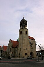
is one of the four medieval churches which encompass the Innenstadt (city centre) of Osnabrück. Before reconstruction of the Marienkirche started from...
18 KB (2,260 words) - 07:33, 9 October 2022

Kalkhügel (category Geography of Osnabrück)
Kalkhügel district is situated in the south-west of Osnabrück. It borders on the districts of Wüste, Innenstadt, Schölerberg, Nahne, Sutthausen and Hellern (in...
2 KB (157 words) - 06:53, 28 August 2024
Manuel Gava (category Politicians from Osnabrück)
association Altstadt-Westerberg-Innenstadt of the Osnabrück SPD. Since March 2019, Gava has been chairman of the Osnabrück Stadt SPD sub-district. In August...
8 KB (673 words) - 15:49, 21 February 2024

Hellern (category Geography of Osnabrück)
the Innenstadt, and is one of the largest arterial roads in Osnabrück. Regular city and regional bus lines serve Hellern, connecting it to Osnabrück Hauptbahnhof...
3 KB (443 words) - 06:52, 28 August 2024

40 kilometres (25 mi) north of Münster, 45 kilometres (28 mi) west of Osnabrück and 45 kilometres (28 mi) east of Hengelo (Netherlands). Although the...
10 KB (950 words) - 08:04, 20 August 2024
Schölerberg (category Geography of Osnabrück)
a district of Osnabrück, Germany, with approximately 13,900 residents. The district of Schölerberg is located in the south of Osnabrück. The only stream...
6 KB (761 words) - 06:53, 28 August 2024

5404 Westerkappeln 5405 Hasbergen (Osnabrück) 5406 Belm 5407 Wallenhorst 5409 Hilter am Teutoburger Wald 541 Osnabrück 542 5421 Dissen am Teutoburger Wald...
186 KB (15,928 words) - 05:42, 6 September 2024
January 2024. "Zwei Tote in Rudolstadt: Mysteriöse Schießerei in der Innenstadt". Der Spiegel (in German). 5 April 2005. ISSN 2195-1349. Retrieved 4 September...
688 KB (17,436 words) - 22:15, 6 September 2024
Finland (1959) Lund, Sweden (1990) Newport News, United States (2007) Osnabrück, Germany (1988) Szczecin, Poland (2010) Greifswald has friendly relations...
47 KB (4,471 words) - 20:02, 27 August 2024

Köln Hauptbahnhof (category Innenstadt, Cologne)
Hauptbahnhof Separation station Aerial view in 2010 General information Location Innenstadt, Cologne, North Rhine-Westphalia Germany Coordinates 50°56′33″N 6°57′29″E...
46 KB (2,727 words) - 21:44, 3 August 2024

Innenstadt, Cologne in 1945...
38 KB (1,969 words) - 13:05, 30 August 2024

Western Pomerania District 1945, Vol. 3, Szczecin 1945. Boeder, F. (1930). Innenstadt von Greifenberg in Pommern aus der Zeit um 1930 – (schematische Darstellung)...
104 KB (13,234 words) - 16:00, 14 August 2024

Martinsried (chemistry and biotechnology campus), the Ludwigsvorstadt (Klinikum Innenstadt) and in the Lehel (Institut am Englischen Garten), across from the main...
53 KB (3,813 words) - 05:55, 29 July 2024
Bärenkämpen Bölhorst Dankersen Dützen Haddenhausen Häverstädt Hahlen Innenstadt (town centre) Königstor Kutenhausen Leteln-Aminghausen Meißen Minderheide...
120 KB (13,682 words) - 14:30, 2 September 2024

Aegidientorplatz. Entwicklung und Veränderung eines Platzes am Rande der Innenstadt von Hannover". Hannoversche Geschichtsblätter. N.S. Vol. 35 (1981) p. 159–180...
18 KB (1,778 words) - 23:28, 24 March 2024

train station in Düsseldorf, near Kling Klang Studio, as part of the Innenstadt Mainstream e.V., their artist and musician association, which also included...
32 KB (3,752 words) - 07:36, 9 April 2024
"Judicium Ignis: 500 Jahre Hexenhammer – Frauenprozession durch die Kasseler Innenstadt", in: Feministische Kulturpädagogik: Projekte und Konzepte, Akademie Remscheid...
9 KB (1,116 words) - 08:45, 20 May 2023