
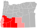
Josephine County is one of the 36 counties in the U.S. state of Oregon. As of the 2020 census, the population was 88,090. The county seat is Grants Pass...
26 KB (2,696 words) - 23:42, 19 July 2024

Cochise County, Arizona. Josephine was born in New York to a Prussian Jewish family. Her father was a baker. They moved to San Francisco, where Josephine attended...
110 KB (12,568 words) - 23:19, 25 August 2024
people with the name) Josephine (singer), a Greek pop singer Josephine, Texas, United States Josephine County, Oregon, a county located in the U.S. state...
4 KB (356 words) - 09:56, 22 May 2024

Union, Wallowa, and Wheeler. In May 2022, voters in Douglas and Josephine counties rejected proposals to join, causing the proponents to scale back the...
30 KB (1,967 words) - 17:33, 17 August 2024

Lake Josephine is a lake in Ramsey County, in the U.S. state of Minnesota. Lake Josephine was named for Josephine McKenty, an early settler. List of lakes...
3 KB (62 words) - 09:59, 30 August 2024

Grants Pass, Oregon (category Cities in Josephine County, Oregon)
Grants Pass is a city in and the county seat of Josephine County, Oregon, United States. The city is located on Interstate 5, northwest of Medford, along...
36 KB (3,136 words) - 03:39, 27 August 2024
cancelled training, games, and tournaments. By May 14, 2021, 31 of Oregon's 36 counties had met OHA requirements to enter the first phase of a three-phase process...
442 KB (17,848 words) - 21:01, 21 August 2024
Sunny Valley, Oregon (category Unincorporated communities in Josephine County, Oregon)
Sunny Valley is an unincorporated community in Josephine County, Oregon, United States. Sunny Valley lies just east of exit number 71, the Sunny Valley...
4 KB (85 words) - 06:31, 29 July 2023

There are 36 counties in the U.S. State of Oregon. The Oregon Constitution does not explicitly provide for county seats; Article VI, covering the "Administrative...
14 KB (270 words) - 14:29, 20 August 2024

Forest (part) Lane County (north) Klamath County (east) Jackson County (south) Josephine County (south) Curry County (southwest) Coos County (west) As of the...
27 KB (2,451 words) - 02:57, 28 August 2024

portion of Lane County and the unorganized area south of Douglas and Umpqua Counties. It included lands which now lie in Coos, Curry, Josephine, Klamath and...
28 KB (2,528 words) - 23:25, 10 August 2024

Josephine Peak is a 5,561-foot-elevation (1,695 meter) mountain summit located in the San Gabriel Mountains, in Los Angeles County, California, United...
5 KB (370 words) - 15:09, 18 July 2024

Williams, Oregon (category Unincorporated communities in Josephine County, Oregon)
is an unincorporated community and census-designated place (CDP) in Josephine County, Oregon, United States. As of the 2010 census it had a population of...
9 KB (478 words) - 09:33, 26 August 2024

Oregon's 4th congressional district (category Josephine County, Oregon)
United States House of Representatives The district gained most of Josephine County from the 2nd district in the 2002 redistricting, but also lost most...
30 KB (305 words) - 16:17, 29 August 2024

Oregon's 2nd congressional district (category Josephine County, Oregon)
Josephine, Klamath, Lake, Malheur, Morrow, Sherman, Umatilla, Union, Wallowa, Wasco, Wheeler counties, all but a small sliver of Jefferson County and...
34 KB (493 words) - 19:36, 5 August 2024

Josephine Cochran (later Cochrane; née Garis; March 8, 1839 – August 3, 1913) was an American inventor who invented the first successful hand-powered...
14 KB (1,498 words) - 23:38, 23 August 2024

Rogue Valley (category Landforms of Josephine County, Oregon)
Located along the middle Rogue River and its tributaries in Josephine and Jackson counties, the valley forms the cultural and economic heart of Southern...
8 KB (693 words) - 01:49, 9 July 2024

Cave Junction, Oregon (category Cities in Josephine County, Oregon)
Cave Junction is a city in Josephine County, Oregon, United States. As of the 2020 census, the city population was 2,071. Its motto is the "Gateway to...
52 KB (5,459 words) - 07:13, 29 August 2024

in Siskiyou County as well as Jackson County, Oregon. Josephine County, Oregon - northwest Jackson County, Oregon - north Klamath County, Oregon - northeast...
58 KB (2,654 words) - 20:58, 29 August 2024

Rogue River (Oregon) (category Rivers of Josephine County, Oregon)
River, all in Jackson County; Grants Pass and Galice in Josephine County; and Agness, Wedderburn and Gold Beach in Curry County. Significant tributaries...
95 KB (10,822 words) - 19:19, 17 August 2024
Josephine Hart, Baroness Saatchi (1 March 1942 – 2 June 2011), was an Irish writer, theatrical producer and television presenter who lived in London....
5 KB (382 words) - 09:54, 19 March 2024
Southern Oregon (section Counties)
Lane County and generally west of the Cascade Range, excluding the southern Oregon Coast. Counties include Douglas, Jackson, Klamath, and Josephine. It...
6 KB (294 words) - 12:59, 16 August 2024

Roy Masters (commentator) (category People from Josephine County, Oregon)
Roy Masters (born 2 April 1928, died 22 April 2021) was an English-born American author, radio personality, businessman and hypnotist. He was the creator...
13 KB (1,611 words) - 21:28, 5 August 2024

Jefferson Public Radio (category Mass media in Josephine County, Oregon)
Jefferson Public Radio (JPR) is a regional public radio broadcasting network serving over a million potential listeners in Southern Oregon and the Shasta...
13 KB (802 words) - 06:19, 7 July 2024
Selma, Oregon (category Unincorporated communities in Josephine County, Oregon)
is an unincorporated community and census-designated place (CDP) in Josephine County, Oregon, United States. As of the 2010 census it had a population of...
8 KB (436 words) - 12:23, 26 August 2024

Illinois River (Oregon) (category Rivers of Josephine County, Oregon)
confluence of its east and west forks near Cave Junction in southern Josephine County. Its drainage basin includes Sucker Creek, which rises in the Red Buttes...
12 KB (1,071 words) - 17:51, 31 July 2024
Pleasant Valley is an unincorporated community in Josephine County, Oregon, United States. It is located about 11 miles (18 km) north of Grants Pass, just...
2 KB (145 words) - 18:44, 9 May 2024

Jackson County, including Medford, Ashland and Central Point. The Medford metropolitan area also includes Grants Pass in neighboring Josephine County, though...
6 KB (274 words) - 01:50, 9 July 2024

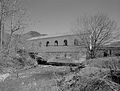
Oregon Caves Chateau (category National Register of Historic Places in Josephine County, Oregon)
Historic American Buildings Survey (HABS) No. OR-145-A, "Oregon Caves National Monument, Chateau, 19000 Caves Highway, Cave Junction, Josephine County, OR"...
8 KB (891 words) - 20:40, 20 December 2023
13139°N 123.87056°W / 42.13139; -123.87056 (Doe Gap (Curry County, Oregon)) Josephine Mountain 1141113 Domingo Pass 6,417 ft (1,956 m) 42°12′20″N 118°46′08″W...
83 KB (54 words) - 23:05, 27 December 2022