
Kentucky Route 194 (KY 194) is an 85.945-mile-long (138.315 km) state highway in Kentucky that runs from Kentucky Route 1428 east of Emma to Virginia...
7 KB (231 words) - 17:49, 16 February 2024

Kentucky Route 632 (KY 632) is a 14.019-mile-long (22.561 km) state highway in Pike County, Kentucky, that runs from Kentucky Route 194 at Kimper to KY...
2 KB (81 words) - 16:37, 31 July 2023
194 A.D. is a year. 194 may also refer to: 194 (number) Connecticut Route 194 Kentucky Route 194 Maryland Route 194 Oregon Route 194 Pennsylvania Route...
1 KB (162 words) - 10:30, 29 July 2015
highway) Kentucky Route 194 Maine State Route 194 Maryland Route 194 M-194 (Michigan highway) (former) Minnesota State Highway 194 New York State Route 194 (former)...
2 KB (181 words) - 23:00, 4 April 2024

Pike County, Kentucky, United States that was established on August 14, 1949. It is at the junction of Kentucky Route 194 and Kentucky Route 2062 3.5 miles...
3 KB (151 words) - 21:20, 1 August 2024
unincorporated community in Pike County, Kentucky. Kimper is located at the junction of Kentucky Route 194 and Kentucky Route 632, 9.3 miles (15.0 km) east of...
3 KB (119 words) - 21:53, 26 July 2023

becomes the short Kentucky Route 194 Spur upon crossing the Tug Fork of the Big Sandy River. The northern terminus is at U.S. Route 52 three miles (5 km)...
2 KB (133 words) - 18:41, 16 February 2024

in Kentucky to Interstate 64 at Charleston, West Virginia. In Kentucky, US 119 is a two- and four-lane highway running from Pineville at U.S. Route 25E...
55 KB (2,217 words) - 16:55, 3 June 2024

West Virginia and relied on a swinging bridge across the Tug Fork to Kentucky Route 194. The bridge was too narrow for vehicular traffic and had deteriorated...
7 KB (481 words) - 05:28, 11 June 2024

Kentucky Route 80 (KY 80) is a 483.55-mile-long (778.20 km) state highway in the southern part of the U.S. state of Kentucky. The route originates on...
64 KB (1,742 words) - 04:20, 25 July 2024

Kentucky (US: /kənˈtʌki/ kən-TUK-ee, UK: /kɛn-/ ken-), officially the Commonwealth of Kentucky, is a landlocked state in the Southeastern region of the...
216 KB (19,424 words) - 13:46, 10 September 2024

where it becomes a two-lane route, and continues through Hustonville, crossing the drainage divide between the Kentucky and Green river watersheds and...
15 KB (1,559 words) - 01:39, 5 August 2024
U.S. Route 150 (US 150) in Kentucky is a 121.097-mile-long (194.887 km) east–west highway that runs from the Indiana state line above the Ohio River to...
22 KB (552 words) - 21:52, 14 February 2024

Kentucky Route 70 (KY 70) is a long east-east state highway that originates at a junction with U.S. Route 60 (US 60) in Smithland in Livingston County...
58 KB (3,304 words) - 18:56, 22 May 2024

Kentucky Route 3519 (KY 3519) is a secondary highway located entirely in Logan County in south-central Kentucky. The station begins at the junction with...
4 KB (209 words) - 02:06, 5 February 2024

Route 62 (US 62) in Kentucky runs for a total of 391.207 miles (629.587 km) across 20 counties in western, north-central, and northeastern Kentucky....
53 KB (1,263 words) - 16:20, 23 July 2024

U.S. Route 42 (US 42) is an east–west United States highway that runs southwest–northeast for 350 miles (560 km) from Louisville, Kentucky to Cleveland...
51 KB (2,236 words) - 16:34, 31 August 2024
A special Kentucky Route (neologistically a bannered Kentucky Route) is a special route of the system of the system of state highways in the Commonwealth...
7 KB (494 words) - 18:21, 14 March 2022
U.S. Route 231 (US 231) in Tennessee runs north–south for 121.15 miles (194.97 km), entirely in Middle Tennessee, that starts south of Fayetteville at...
21 KB (1,251 words) - 06:46, 5 February 2024

Kentucky Route 98 (KY 98) is a 13.910-mile-long (22.386 km) state highway in Kentucky that runs from Kentucky Route 100 in Scottsville to Kentucky Route...
3 KB (115 words) - 17:52, 16 February 2024

LaRue counties meet. Raywick is concentrated around the intersection of Kentucky Route 527, which leads north 6 miles (10 km) to Loretto and south over the...
8 KB (619 words) - 19:37, 23 May 2024
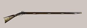
Long rifle (redirect from Kentucky Rifle)
The long rifle, also known as the Kentucky rifle, Pennsylvania rifle, or American long rifle, is a muzzle-loading firearm used for hunting and warfare...
27 KB (3,311 words) - 23:43, 10 April 2024

rule-class city in and the county seat of Carter County, Kentucky, United States, on U.S. Route 60 and Interstate 64 in the state's northeastern region...
13 KB (1,169 words) - 06:18, 9 April 2024

Kentucky Route 28 (KY 28) is a 36.217-mile-long (58.286 km) state highway in the U.S. state of Kentucky that travels from KY 11 and KY 30 in Booneville...
4 KB (204 words) - 17:50, 16 February 2024

Kentucky Route 1426 (KY 1426) is a 34.708-mile-long (55.857 km) state highway in Kentucky. KY 1426's western terminus is at U.S. Route 23 (US 23) in Banner...
4 KB (74 words) - 17:53, 16 February 2024

Kentucky Route 164 (KY 164) is a 36.247-mile-long (58.334 km) state highway in western Kentucky. KY 164 begins its run on Linton Road from U.S. Route 68...
4 KB (264 words) - 17:52, 16 February 2024

U.S. Route 431 (US 431) in Kentucky runs 86.93 miles (139.90 km) from the Tennessee state line south of Adairville to US 60 at Owensboro. It crosses the...
16 KB (849 words) - 23:44, 1 June 2024

Richlawn is a home rule-class city in eastern Jefferson County, Kentucky, United States. The population was 415 at the 2020 United States Census. The population...
7 KB (516 words) - 02:27, 17 July 2024

(1968), p. 194. Adams, Luther J. (Autumn 2001). "African American Migration to Louisville in the Mid-Twentieth Century". The Register of the Kentucky Historical...
159 KB (14,524 words) - 18:29, 2 September 2024
situated along U.S. Route 62 between Central City to the northeast and Greenville to the southwest. Kentucky Route 189 serves as a bypass route around Powderly...
9 KB (791 words) - 03:36, 18 July 2023