
Kentucky Route 208 (KY 208) is a 11.1-mile-long (17.9 km) state highway in the U.S. state of Kentucky. The highway travels through mostly rural areas...
4 KB (233 words) - 17:52, 16 February 2024

Creek immediately before its eastern terminus at KY 208 (Calvary Road) south of Calvary. Kentucky Route 413 is a 5.022-mile-long (8.082 km) supplemental...
131 KB (12,134 words) - 17:05, 29 April 2024
Route 208 California State Route 208 (former) Florida State Road 208 Georgia State Route 208 Kentucky Route 208 Maine State Route 208 Maryland Route 208 M-208...
2 KB (163 words) - 23:28, 4 April 2024

have portions within the State Primary and State Secondary systems. Kentucky Route 200 is a 18.041-mile-long (29.034 km) rural secondary highway that traverses...
91 KB (9,054 words) - 18:30, 9 May 2024

Major intersections The entire route is in Louisville, Jefferson County. Kentucky Route 3079 is a 0.129-mile-long (0.208 km) supplemental road in the city...
41 KB (3,753 words) - 11:03, 27 September 2023

Kentucky Route 15 begins at a junction of US 119/Corridor F & Business KY 15 in Whitesburg, and terminates in Winchester at US 60. It is a major route...
20 KB (556 words) - 23:56, 8 April 2023

KY 208. The entire route is in Marion County. KML file (edit • help) Template:Attached KML/Kentucky Route 2154 KML is not from Wikidata Kentucky Legislative...
4 KB (198 words) - 07:43, 27 September 2023

McCreary County that runs from Kentucky Route 92 east of Smith Town to Kentucky Route 1651 southwest of Whitley City. Kentucky Route 702 (KY 702) is a 2.855-mile-long...
58 KB (3,524 words) - 23:33, 29 January 2023

U.S. Route 31E (US 31E) is the eastern parallel route for U.S. Highway 31 from Nashville, Tennessee, to Louisville, Kentucky. US 31E begins as the Ellington...
33 KB (1,342 words) - 01:29, 5 December 2023

community of Alcorn where the road ends state maintenance. Kentucky Route 2005 is a 5.100-mile long (8.208 km) rural secondary highway in Harlan County. It begins...
68 KB (6,138 words) - 10:38, 27 September 2023

Illinois to U.S. Route 25 in Mount Vernon, Kentucky. In the state of Illinois, U.S. 150 runs from the Quad City International Airport at U.S. Route 6 southeast...
31 KB (1,002 words) - 05:11, 21 October 2023

U.S. Route 23 (US 23) is a 157.765-mile-long (253.898 km) United States Numbered Highway in the state of Kentucky. It travels from the Virginia state line...
20 KB (380 words) - 23:06, 8 March 2024

U.S. Route 60 (US 60) is a major U.S. Highway in the American state of Kentucky. In the early days of the U.S. Highway System, US 60 was originally to...
75 KB (1,848 words) - 23:01, 8 March 2024

Kentucky Route 70 (KY 70) is a long east-east state highway that originates at a junction with U.S. Route 60 (US 60) in Smithland in Livingston County...
58 KB (3,304 words) - 18:56, 22 May 2024

where it becomes a two-lane route, and continues through Hustonville, crossing the drainage divide between the Kentucky and Green river watersheds and...
15 KB (1,557 words) - 19:24, 30 December 2023

U.S. Route 68 (US 68) is a United States highway that runs for 560 miles (900 km) from northwest Ohio to Western Kentucky. The highway's western terminus...
68 KB (1,546 words) - 05:30, 9 February 2024

Route 62 (US 62) in Kentucky runs for a total of 391.207 miles (629.587 km) across 20 counties in western, north-central, and northeastern Kentucky....
53 KB (1,265 words) - 05:12, 14 June 2024

The Kentucky Route 2014 Bridge along Kentucky Route 2014 in Bell County, Kentucky, was a truss bridge spanning the Cumberland River near Pineville, Kentucky...
5 KB (518 words) - 15:29, 21 May 2023

Kentucky Route 536 (KY 536) is a state highway that connects Rabbit Hash to Alexandria via Florence and Independence in Northern Kentucky, United States...
7 KB (432 words) - 06:26, 3 May 2023
U.S. Route 127 (US 127) in Tennessee is a 129.5-mile-long (208.4 km) United States Numbered Highway from Chattanooga to the Kentucky state line at Static...
17 KB (995 words) - 22:21, 7 June 2022

Kentucky Route 1681 (KY 1681) is a 21.448-mile (34.517 km) state highway in Kentucky that runs from Kentucky Route 1659 immediately north of Millville...
5 KB (301 words) - 17:53, 16 February 2024

Daniel Boone (category Kentucky pioneers)
of the 18th century, more than 200,000 people had entered Kentucky by following the route marked by Boone. Boone served as a militia officer during the...
57 KB (7,664 words) - 04:31, 25 June 2024

southbound I-65 traffic enters Kentucky from Jeffersonville, Indiana, via the John F. Kennedy Memorial Bridge. The route is reportedly one of the heaviest...
27 KB (1,714 words) - 19:49, 8 May 2024
Bert T. Combs Mountain Parkway (redirect from Kentucky Route 9000)
eastern Kentucky. The route runs from Interstate 64 just east of Winchester southeast for 75.627 miles (121.710 km) to a junction with U.S. Route 460 near...
8 KB (468 words) - 15:38, 2 March 2024
List of highways numbered 1000–1499 (redirect from Route 1128)
listed below are all in the United States, primarily Louisiana, Texas, and Kentucky, though there are some roads in this range in Georgia and New Mexico. The...
55 KB (154 words) - 14:05, 5 April 2024
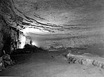
Mammoth Cave National Park (redirect from Sand Cave, Kentucky)
from I-65 at Exit 48. The parkway connects with Kentucky Route 70 from the north and Kentucky Route 255 from the south within the park. Human activity...
67 KB (7,843 words) - 09:42, 14 June 2024

Much of Upton is concentrated around the intersection of US 31W and Kentucky Route 224, which runs westward in the direction of Leitchfield. Interstate...
9 KB (772 words) - 20:41, 14 November 2023

County, Kentucky. It is intended to be a complete list of the properties on the National Register of Historic Places in Marion County, Kentucky, United...
6 KB (378 words) - 16:36, 25 August 2023

Flatwoods is a home rule-class city in Greenup County, Kentucky, United States. The population was 7,325 at the 2020 census, making it the largest city...
15 KB (1,357 words) - 19:28, 16 May 2024
and census-designated place in Daviess County, Kentucky, in the United States. The population was 208 as of the 2020 census. The community is located...
5 KB (242 words) - 15:44, 15 November 2023