
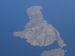
Kythira Strait (also Kythirian Straits, Kythira–Antikythira Strait or Kithera Channel) is a waterway off Kythira in Southern Greece. The Kythira–Antikythira...
5 KB (547 words) - 05:58, 7 August 2024

convoys. The ships were en route to rendezvous with the cruisers in the Kythira Strait when she was struck by three bombs dropped by Stukas of StG 2 and sank...
15 KB (1,680 words) - 17:22, 23 September 2024

Islands March 1944 Unknown HMS Sickle Kythira Strait, Greece June 1944 Most likely sunk by naval mine HMS Stratagem Strait of Malacca 22 November 1944 Sunk...
48 KB (306 words) - 12:43, 6 April 2024
damaged Naiad and the rest of his Force C. Force A1 headed east into the Kythira Strait, rendezvousing with Force C between 13:30 and 14:00. As the more senior...
27 KB (3,209 words) - 18:46, 20 September 2024

submarine UB-47 58 miles south-east of Cape Matapan in Greece, in the Kythira Strait. The ship went down fairly quickly with a loss of 36 crew members and...
18 KB (1,877 words) - 11:21, 4 October 2024
earthquake reportedly occurred at around 09:00 on 9 March 1630 in the Kythira Strait, off the coast of Crete. Until the mid-1990s, the earthquake had traditionally...
5 KB (607 words) - 01:49, 5 September 2024

Antikythera (category Kythira)
reform, it is part of the municipality of Kythira island. Antikythera may also refer to the Kythira-Antikythira Strait, through which Mediterranean water enters...
12 KB (1,179 words) - 05:43, 7 August 2024
and Archaeological Evidence of Earthquakes and Tsunamis Felt in the Kythira Strait, Greece.". Tsunami Research at the End of a Critical Decade. Kluwer...
15 KB (1,622 words) - 04:32, 23 August 2024

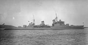
May 1941 A Town-class light cruiser sunk by German dive bombers in Kythira Strait about 12 nautical miles (22 km; 14 mi) north of Crete. 35°50′N 023°00′E...
181 KB (1,582 words) - 23:52, 13 September 2024

to Ultra signals intercepts the Allies sent a squadron through the Kythira Strait to the west of Crete. This was Force D, consisting of the cruisers HMS Ajax...
55 KB (6,945 words) - 11:45, 20 May 2024
death 22 May 1941(1941-05-22) (aged 23) Place of death HMS Gloucester, Kythira Strait, off Crete Height 5 ft 8 in (1.73 m) Position(s) Outside-right Youth...
5 KB (413 words) - 21:50, 9 May 2024

Taranto; In April, south of Cape Krio and in Kythira Strait; In May, between Alexandria and Kasos Strait at first, then south of Crete. On May 10, 1941...
10 KB (1,033 words) - 08:48, 3 February 2024
speed of the target. From 15 to 22 March 1941 she was deployed in the Kythira Strait. On the night of March 19, Malachite sighted a cruiser escorted by several...
14 KB (1,625 words) - 08:50, 3 February 2024

considered likely that she was sunk by mines on her way back to Malta in the Kythira Strait on or around 18 June. During her service with the Royal Navy, Sickle...
21 KB (2,086 words) - 21:27, 20 September 2024

Gulf, SE Laconian Gulf, ESE Corfu Kefalonia Ithaca Zakynthos Lefkada Paxi Kythira Antikythera Antipaxi Arkoudi Atokos Kalamos Kastos Ksamil Islands Kravia...
12 KB (1,035 words) - 17:37, 23 September 2024

Rock (off the Northwest point) and across to Cape Trakhili in Kythira Island, through Kythira to the Northwest point (Cape Karavugia) and thence to Cape...
50 KB (5,414 words) - 04:53, 23 September 2024

It is separated from Boeotia in mainland Greece by the narrow Euripus Strait (only 40 m (130 ft) at its narrowest point). In general outline it is a...
32 KB (3,348 words) - 04:11, 20 September 2024
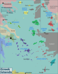
72839; 19.63481 (Nisída Karávi) Kythira, 36°15′27″N 22°59′51″E / 36.25750°N 22.99750°E / 36.25750; 22.99750 (Kythira) Kythros, 38°35′07″N 20°47′58″E...
45 KB (7,917 words) - 04:01, 4 October 2024

of Venice, namely Syros, Aegina, Ios, Paros, Tinos, Karpathos, Kasos, Kythira, and Naxos. In the same year, Barbarossa raided Corfu and obliterated the...
58 KB (6,783 words) - 20:55, 30 September 2024
handkerchief"), "Στου Πάπα το μπουγάζι" ("In the Pope's strait"), "Ανάμεσα Τσιρίγο" ("Between Kythira"), "Από ξένο τόπο" ("From a foreign place"), "Από την...
24 KB (2,308 words) - 02:36, 15 September 2024
just to the north of Karpathos, separated from it by a 100 m (330 ft) wide strait. It is part of the Dodecanese archipelago. In ancient times, a city-state...
3 KB (263 words) - 00:06, 26 August 2024
Second largest ocean, including adjacent Denmark Strait, Greenland Sea, Norwegian Sea, Barents Sea, Strait of Gibraltar and Mediterranean Sea, Black Sea...
87 KB (460 words) - 03:21, 8 May 2024

populous island; Euboea, separated from the mainland by the 60 m-wide Euripus Strait, is the second largest, followed by Lesbos and Rhodes. The Greek islands...
285 KB (25,765 words) - 12:27, 30 September 2024
Ioannina, Preveza, Thesprotia) Ionian Islands (Corfu, Ithaca, Kefalonia, Kythira, Lefkada, Paxi, Zakynthos) Macedonia (Chalkidiki, Drama, Florina, Grevena...
59 KB (518 words) - 18:40, 21 July 2024

the Mediterranean Sea. The island is separated from Turkey by the Chios Strait. Chios is notable for its exports of mastic gum and its nickname is "the...
53 KB (5,975 words) - 20:10, 3 October 2024

a classical allusion for the submarine communications cable across Bass Strait from Apollo Bay, Victoria to Stanley, Tasmania. A statue of Amphitrite stands...
14 KB (1,444 words) - 13:03, 17 August 2024

(656 ft) wide sea channel, with the town of Galatas on the mainland across the strait. Its surface area is about 31 square kilometres (12 sq mi) and it has 3...
17 KB (2,186 words) - 21:03, 21 July 2024
on seven individual islands, notably: Cephalonia (Kephalonia), Cerigo (Kythira), Ithaca, Paxos, Santa Maura (Leucada/Lefkada) and Zante (Zakynthos) in...
36 KB (4,959 words) - 05:57, 22 September 2024
Turkey, from which it is separated by the 1.6-kilometre-wide (1.0 mi) Mycale Strait. It is also a separate regional unit of the North Aegean region. In ancient...
51 KB (5,480 words) - 16:02, 15 September 2024
36.000; 23.167 (Aegean Sea) Aegean Sea Passing between the islands of Kythira and Antikythera, Greece Passing just north of Saria Island, Greece 36°0′N...
11 KB (522 words) - 23:41, 25 September 2024