been named for Lady Clara Barron, wife of Major General Sir Harry Barron, who was Governor of Tasmania from 1909 to 1913. The Barrons married in 1877...
4 KB (282 words) - 10:48, 26 July 2024
World War I. Barron inspired the names of the settlement Lady Barron, Tasmania, and Lady Barron Falls. She was married to Sir Harry Barron, who was the...
9 KB (879 words) - 20:37, 23 September 2024

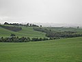
Lady Barron Falls, a tiered–cascade waterfall on the Lady Barron Creek, is located in the Central Highlands region of Tasmania, Australia. The Lady Barron...
4 KB (246 words) - 10:51, 26 July 2024
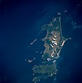
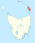
Flinders Island (redirect from Flinders Island, Tasmania)
to the island weekly by Furneaux Freight between Bridport, Tasmania and Lady Barron, Tasmania and also monthly from Port Welshpool, Victoria. Australian...
21 KB (1,803 words) - 10:22, 21 July 2024

General Sir Harry Barron, KCMG, CVO (11 August 1847 – 27 March 1921) was a British Army officer who served as Governor of Tasmania from 1909 to 1913,...
8 KB (609 words) - 20:44, 15 September 2024

Furneaux Group (redirect from Lady Barron Island)
Clarke Island. The group contains five settlements: Killiecrankie, Emita, Lady Barron, Cape Barren Island, and Whitemark on Flinders Island, which serves as...
17 KB (419 words) - 21:59, 22 September 2024
locality in 1963. Bass Strait forms the eastern boundary. The B85 route (Lady Barron Road) enters from the south-west and exits to the south. Route C803 (Lackrana...
3 KB (186 words) - 17:23, 25 July 2024
Strzelecki National Park forms most of the southern boundary. The B85 route (Lady Barron Road Road) enters from the north-west and runs through the village to...
3 KB (212 words) - 17:59, 25 July 2024
and Bridport mainly for golfers who fly into Tasmania to play. A ferry operates from Bridport to Lady Barron on Flinders Island, part of the Furneaux Group...
7 KB (331 words) - 16:23, 9 December 2023

Mount Field National Park (category National parks of Tasmania)
name in 1947. Mount Field National Park was named for Judge Barron Field, who visited Tasmania as an itinerant judge in 1819 and 1821. During the Pleistocene...
11 KB (1,042 words) - 09:43, 5 July 2024

branch of the Red Cross, taking over from the inaugural president Lady Clara Barron. Ellison-Macartney returned to live in England with her family in...
8 KB (876 words) - 05:32, 10 October 2024
Whitemark (redirect from Whitemark, Tasmania)
kilometres (2.3 mi) northwest of Whitemark. Route B85 (Palana Road / Lady Barron Road) passes through from north-west to south. "2021 Whitemark, Census...
9 KB (476 words) - 13:04, 26 September 2024

lakes, snow-covered peaks in winter, and breathtaking waterfalls like Lady Barron Falls, Horseshoe Falls, and Russell Falls. Visitors can engage in various...
11 KB (995 words) - 00:43, 2 September 2024

Flinders Council (category Local government areas of Tasmania)
Killiecrankie Lackrana Lady Barron Leeka Loccota Lughrata Memana Palana Ranga Strzelecki Whitemark Wingaroo List of local government areas of Tasmania "3218.0 – Regional...
6 KB (309 words) - 00:09, 4 September 2024

Hobart, Tasmania: Centre for Tasmanian Historical Studies. Retrieved 28 April 2020. Burn 1905, pp. 26–27. Hendy-Fooley, G (12 September 1933). "Barron Field"...
66 KB (7,458 words) - 00:03, 9 August 2024
Falls Kindred Falls Knyvet Falls Kohls Falls Krushka Falls Ladder Falls Lady Barron Falls Leeaberra Falls Lewis Falls Liffey Falls Lilydale Falls Lobster...
4 KB (507 words) - 18:02, 22 August 2022
of a land bridge to Tasmania the remnants of which is the Furneaux Group of islands. A ferry operates from Welshpool to Lady Barron Island, part of the...
2 KB (215 words) - 03:08, 2 February 2024
local government area (LGA) of Flinders in the North-east LGA region of Tasmania. The locality is about 21 kilometres (13 mi) south-east of the town of...
3 KB (173 words) - 18:13, 25 July 2024

Gerald Strickland, 1st Baron Strickland (redirect from Margaret, Lady Strickland)
Prime Minister of Malta, Governor of the Leeward Islands, Governor of Tasmania, Governor of Western Australia and Governor of New South Wales, in addition...
16 KB (1,264 words) - 08:04, 17 August 2024

TasPorts (category Government-owned companies of Tasmania)
brand. Bell Bay Burnie Currie Devonport Devonport Airport Grassy Hobart Lady Barron (Flinders Island) Smithton Stanley Strahan Triabunna Whitemark (Flinders...
5 KB (270 words) - 23:18, 14 August 2024

Truganini (category History of Tasmania)
There were also Tasmanian Aboriginal people living on Flinders and Lady Barron Islands. Fanny Cochrane Smith (1834–1905) outlived Truganini by 30 years...
44 KB (5,306 words) - 23:35, 3 October 2024

is a list of all bounded localities in Tasmania, Australia, as recognised by the Land Information System Tasmania. The definition of a locality for this...
130 KB (178 words) - 18:10, 14 February 2022
Meander Valley Council (redirect from Meander Valley Council, Tasmania)
Meander Valley Council is a local government body in northern Tasmania. It covers the western outskirts of Launceston, and further westward along the Meander...
10 KB (305 words) - 03:42, 12 April 2024
Prince of Wales Theatre, Hobart (category Former theatres in Tasmania)
1910 in the presence of the Governor of Tasmania, Sir Harry Barron, Lady Clara Emily Barron, Premier of Tasmania Sir Elliott Lewis and other Hobart notables...
9 KB (875 words) - 13:30, 21 July 2024

Division of Lyons (state) (redirect from Division of Lyons, Tasmania)
central and eastern Tasmania. Lyons is named jointly in honour of Joseph Lyons, Prime Minister of Australia (1932–1939); Premier of Tasmania (1923–1928), and...
33 KB (259 words) - 07:35, 24 August 2024
This is a list of current registered airports in the Australian state of Tasmania. Map all coordinates using OpenStreetMap Download coordinates as: KML GPX...
5 KB (119 words) - 15:34, 31 May 2023
Logan Lagoon (category Conservation areas of Tasmania)
south-eastern corner of Flinders Island, lying some 5 km east of the village of Lady Barron. It is isolated from the sea by a large sand bar which is infrequently...
4 KB (368 words) - 15:38, 13 April 2024
List of hospitals in Australia (redirect from List of hospitals in Tasmania)
Care Tasmania – Lenah Valley Campus – Lenah Valley Calvary Health Care Tasmania – St John's Campus – South Hobart Calvary Health Care Tasmania – St Luke's...
293 KB (17,156 words) - 12:58, 9 October 2024
Road routes in Tasmania assist drivers navigating roads in urban, rural, and scenic areas of the state. The route numbering system is composed of National...
147 KB (1,089 words) - 17:28, 25 July 2024
Central Highlands Council (category Local government areas of Tasmania)
Central Highlands Council is a local government body in Tasmania, encompassing the Central Highlands region of the state. Central Highlands is classified...
8 KB (460 words) - 23:04, 28 December 2023