
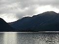
Lake Burbury is a man-made water reservoir created by the Crotty Dam inundating the upper King River valley that lies east of the West Coast Range. Discharge...
7 KB (758 words) - 22:12, 21 March 2023
Sir Stanley Charles Burbury, KCMG, KCVO, KBE (3 December 1909 – 24 April 1995) was an Australian judge. He served as Chief Justice of Tasmania from 1956...
9 KB (777 words) - 06:46, 16 August 2024

abandoned when the nearby mine closed down. It is now submerged beneath Lake Burbury. Cudgegong was a small town in central western New South Wales. Windamere...
110 KB (12,628 words) - 03:47, 8 September 2024
the West Coast region of Tasmania, Australia. It is a tributary into Lake Burbury, previously directly into the upper region of King River The river valley...
3 KB (277 words) - 22:19, 21 March 2023

West Coast Range (section Lakes)
Lake Burbury - created by the damming of the King River by The Hydro Lake Dora Lake Dorothy Lake Huntley - on the eastern side of Mount Tyndall Lake Julia...
36 KB (3,192 words) - 17:45, 3 February 2024

several nearby dams by the Hydro. The Darwin and Crotty dams that comprise Lake Burbury (a popular fishing and recreation venue) were built during this period...
17 KB (1,729 words) - 02:19, 1 September 2024

Coast Range of Western Tasmania, Australia. Lake Beatrice is higher in altitude than the nearby Lake Burbury; however, it is not visible from that level...
6 KB (401 words) - 09:13, 29 May 2023

and Railway Company. The river is impounded by the Crotty Dam to form Lake Burbury, covering 54 square kilometres (21 sq mi) over the former valley and...
12 KB (1,124 words) - 21:58, 2 March 2023
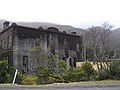
During 2016, Lake Burbury receded to a historically low level and remains of the town became visible. On the eastern shores of Lake Burbury, the land south...
9 KB (906 words) - 22:36, 31 December 2023

peaks, and glacial lakes on its upper eastern reaches, Mount Jukes is situated above the town of Crotty and is west of Lake Burbury. The mountain was named...
7 KB (648 words) - 11:19, 26 April 2023

Australia. The impounded reservoir, also formed by Crotty Dam, is called Lake Burbury. The dam was constructed in 1990 by the Hydro Electric Corporation (TAS)...
6 KB (387 words) - 09:13, 2 April 2022

located in Western Tasmania, Australia. The impounded reservoir is called Lake Burbury. The dam was constructed in 1991 as part of the King River Power Development...
10 KB (899 words) - 11:20, 26 April 2023
workings have been closed down. It is the closest settlement to Lake Burbury, a hydro created lake from the damming of the King River. There are currently no...
6 KB (567 words) - 03:58, 16 April 2023

List of dams and reservoirs in Australia (category Lakes of Australia)
Wales is the 4,798,000-megalitre (1.055×10¹² imp gal; 1.267×10¹² US gal) Lake Eucumbene in the Snowy Mountains, formed by the Eucumbene Dam. There are...
76 KB (509 words) - 20:29, 25 September 2023
power stations, the John Butters Power Station is fed by water from Lake Burbury which is dammed by the Crotty Dam in the gap in the West Coast Range...
9 KB (554 words) - 10:00, 11 January 2024

Tasmania, Australia. The range is located at the north eastern edge of Lake Burbury and is part of the Tasmanian Wilderness World Heritage Area which includes...
9 KB (781 words) - 00:42, 26 December 2023
was taken from the mine to smelters at Crotty (now under the waters of Lake Burbury) then the refined metal taken to a port at Pillinger on the shores of...
5 KB (479 words) - 02:28, 10 March 2024

Dams blockade in the 1980s. Most of the formation now lies under the Lake Burbury impoundment, a result of the Hydro Tasmania King River power development...
3 KB (332 words) - 10:28, 26 April 2023
following their construction of the King River Dam and the impoundment of Lake Burbury. This list incorporates mines on Mount Darwin as the mineral zone of...
5 KB (527 words) - 23:40, 9 July 2024

the creation of Lake Burbury, the highway was re-routed to a narrow point where the Bradshaw bridge could be constructed across the lake. Australia portal...
10 KB (1,033 words) - 07:51, 10 January 2024
eastern wall to its north eastern peak hangs over the western shore of Lake Burbury and, in earlier times, the North Mount Lyell Railway which passed beneath...
8 KB (710 words) - 21:43, 17 October 2022
close to the Mount Lyell mines and workings, at the western edge of Lake Burbury, and east of the old Mount Lyell Mining and Railway Company operations...
4 KB (460 words) - 02:30, 10 March 2024

the West Coast beaches, Lake Burbury and the many peaks – such as Tasmania's tallest, Mount Ossa – in the Cradle Mountain-Lake St Clair National Park....
17 KB (1,941 words) - 14:17, 25 March 2024
range in Western Tasmania, Australia. It is located to the south east of Lake Burbury and occurs in the western edge of the Tasmanian Wilderness World Heritage...
2 KB (202 words) - 04:06, 2 April 2022
the South Eldon River and emptying into the King River, dammed to form Lake Burbury. The river descends 750 metres (2,460 ft) over its 21-kilometre (13 mi)...
4 KB (215 words) - 08:57, 2 April 2022

were utilised right up to the damming of the River and the creation of Lake Burbury by the Hydro Electric Commission in the 1980s. The railway formation...
10 KB (1,186 words) - 12:57, 8 November 2023
145.33278°E / -42.63611; 145.33278 • elevation 0 m (0 ft) Length 29 km (18 mi) Basin features Tributaries • left Pery River Reservoir Lake Burbury...
7 KB (486 words) - 13:05, 5 May 2022

glaciation in the West Coast Range. Lake Margaret lies at the northern side of the mountain, while Lake Beatrice and Lake Burbury at the eastern side. Mount Geikie...
5 KB (404 words) - 18:35, 14 July 2023

and north of Mount Jukes; west of the Tofft River, Thureau Hills, and Lake Burbury; south of Mount Owen and Queenstown. A very rough track approaches the...
6 KB (536 words) - 11:19, 26 April 2023

the Nelson Valley. The falls (on the Nelson River, which flows into Lake Burbury) descend approximately 30 metres (98 ft). Australia portal Environment...
2 KB (142 words) - 07:05, 10 March 2023