Vary". New York Times. Instituto Nacional de Estadística (INE), bases de datos en línea 15°8′N 87°8′W / 15.133°N 87.133°W / 15.133; -87.133 v t e...
5 KB (197 words) - 18:48, 30 May 2024

Yoro is one of the 18 departments into which Honduras is divided. The department contains rich agricultural lands, concentrated mainly on the valley of...
9 KB (305 words) - 09:10, 3 June 2024
Black or Afro-Honduran. Instituto Nacional de Estadística (INE), bases de datos en línea 14°55′N 87°16′W / 14.917°N 87.267°W / 14.917; -87.267 v t e...
3 KB (73 words) - 08:55, 20 July 2022
the Honduran department of Yoro. This political division of 50,930 people is in the north, located between the city of Yoro and the municipality of El...
6 KB (397 words) - 03:53, 15 August 2024

globaldatalab.org. Retrieved 2018-09-13. "Consulta Base de datos INE en línea: Censo de Población y Vivienda 2013" [Consult INE online database: Population...
7 KB (274 words) - 00:06, 13 August 2024
El Progreso (redirect from El Progreso, Yoro)
the major cities in Honduras Instituto Nacional de Estadística (INE), bases de datos en línea 15°24′N 87°48′W / 15.400°N 87.800°W / 15.400; -87.800...
8 KB (766 words) - 03:41, 15 August 2024
Arenal, Honduras (redirect from Arenal, Yoro)
Indigenous and 0.03% White. Instituto Nacional de Estadística (INE), bases de datos en línea 15°21′N 86°50′W / 15.350°N 86.833°W / 15.350; -86.833 v t e...
3 KB (73 words) - 03:20, 19 January 2024
Retrieved 1 July 2023. Instituto Nacional de Estadística (INE), bases de datos en línea 15°12′N 87°53′W / 15.200°N 87.883°W / 15.200; -87.883 v t e...
4 KB (192 words) - 04:12, 6 February 2024
Victoria, Honduras (redirect from Victoria, Yoro)
Afro-Honduran and 0.02% others. Google Maps - Victoria Instituto Nacional de Estadística (INE), bases de datos en línea OpenStreetMap - Victoria v t e...
3 KB (81 words) - 21:53, 7 November 2023

globaldatalab.org. Retrieved 13 September 2018. "Consulta Base de datos INE en línea: Censo de Población y Vivienda 2013" [Consult INE online database: Population...
8 KB (291 words) - 13:18, 6 July 2024
Olanchito (redirect from Olanchito, Yoro)
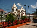
Olanchito is a municipality in the department of Yoro, Honduras, and a town with a population of 49,750 as of 2023. The municipality was founded in 1530...
12 KB (1,348 words) - 12:58, 18 May 2023
El Negrito (category Municipalities of the Yoro Department)
municipalities in Honduras Citypopulation.de Population of cities in Honduras Instituto Nacional de Estadística (INE), bases de datos en línea v t e...
4 KB (205 words) - 03:53, 15 August 2024
Jocón (category Municipalities of the Yoro Department)
Indigenous and 0.01% others. Instituto Nacional de Estadística (INE), bases de datos en línea 15°17′N 86°58′W / 15.283°N 86.967°W / 15.283; -86.967 v t e...
3 KB (76 words) - 11:35, 22 December 2023
Yorito (category Municipalities of the Yoro Department)
Afro-Honduran and 0.01% others. Instituto Nacional de Estadística (INE), bases de datos en línea 15°04′N 87°17′W / 15.067°N 87.283°W / 15.067; -87.283 v t e...
3 KB (79 words) - 09:38, 20 July 2022
Bariloche Airport in San Carlos de Bariloche, Argentina, prematurely, Austral Lineas Aéreas Flight 9, a BAC One-Eleven 420EL (registration LV-JGY), crashes near...
55 KB (6,703 words) - 19:01, 9 September 2024