
State Route 159 (abbreviated SR 159) is part of Maine's system of numbered state highways, located in Penobscot and Aroostook counties. The highway runs...
4 KB (278 words) - 05:20, 6 April 2023

State routes in Maine are highways within the Maine State Highway System that are signed and maintained by the Maine Department of Transportation, and...
91 KB (221 words) - 11:10, 11 April 2024
State Route 9 (SR 9) is a numbered state highway in Maine, running from the New Hampshire border at Berwick in the west to the Canada–US border with New...
21 KB (588 words) - 15:19, 28 August 2024
Illinois Route 159 Indiana State Road 159 Kentucky Route 159 Louisiana Highway 159 Maine State Route 159 Maryland Route 159 Massachusetts Route 159 Nevada...
2 KB (179 words) - 23:31, 4 April 2024
north of Lincoln. It is situated at the intersection of Maine Rte. 11 and Maine State Route 159. The six buildings of the Bradford Farm (1840) in Patten...
17 KB (1,266 words) - 19:36, 28 August 2024

State Route 158 (SR 158) is part of Maine's system of numbered state highways, located entirely within the town of Sherman in Aroostook County. It is a...
3 KB (266 words) - 21:27, 11 September 2024

New England road marking system (redirect from New England Multi-state Route 8)
Portland. Route 25 was replaced by U.S. Route 302, most of New Hampshire Route 25, and Maine State Route 25. Route 25A was replaced by Vermont Route 25 and...
158 KB (6,445 words) - 17:10, 1 February 2024

State Route 11 (SR 11) is a state highway in the U.S. state of Maine. It is a major interregional route which runs nearly the entire length of the state...
33 KB (1,652 words) - 09:12, 2 June 2024

U.S. Route 2 (US 2) in the U.S. state of Maine is a principal east–west route through the central portion of the state, extending from the New Hampshire...
17 KB (468 words) - 01:50, 11 June 2024

State Route 16 (SR 16) is a numbered state highway in Maine, United States. SR 16 runs from the New Hampshire state line (signed as NH-16) at Wentworth...
9 KB (290 words) - 18:21, 16 June 2024

26700°W / 43.65317; -70.26700 State Street is a downtown street in Portland, Maine, United States. Part of Maine State Route 77, it runs one-way for around...
5 KB (452 words) - 22:04, 25 June 2024

and State Route 4. U.S Route 2 leaves the routes and State Route 27 joins the routes. Route 43 heads east and junctions State Route 148. State Route 148...
9 KB (286 words) - 18:19, 16 June 2024

Route 202 (US 202) is a spur route of US 2. It follows a northeasterly and southwesterly direction stretching from Delaware in the south to Maine in...
57 KB (3,188 words) - 05:14, 16 August 2024
Route 2 passes through the village, leading northeast 27 miles (43 km) to Houlton and south 38 miles (61 km) to Mattawamkeag. Maine State Route 159 has...
4 KB (187 words) - 02:26, 11 July 2023

State Route 160 (abbreviated SR 160) is part of Maine's system of numbered state highways, located in the southwestern part of the state. It is a north–south...
5 KB (474 words) - 05:22, 6 April 2023

north–south from Miami, Florida to Houlton, Maine. The highway enters Maine from the New Hampshire state line in Kittery and runs for 303 miles (488 km)...
37 KB (2,566 words) - 10:39, 11 September 2024
Bradford Farm Historic District (category Historic districts on the National Register of Historic Places in Maine)
of Maine State Route 11, the main north-south route through the county, and the associated farmlands extend west and north to Maine State Route 159, which...
3 KB (340 words) - 21:25, 5 August 2023

Newry (/ˈnjʊəri/; from Irish An Iúraigh) is a resort town in Oxford County, Maine, United States. The town’s year-round population was 411 at the 2020 census...
16 KB (1,521 words) - 08:46, 15 August 2024

Route 4 runs through the center of the CDP, leading northwest 40 miles (64 km) to Rangeley and south 46 miles (74 km) to Lewiston. Maine State Route 27...
8 KB (734 words) - 18:09, 2 June 2023
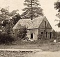
William Sewall House (category Houses on the National Register of Historic Places in Maine)
The Sewall House is located on the north side of Crystal Road (Maine State Route 159) just west of the Island Falls Post Office in the village center...
5 KB (525 words) - 14:01, 25 April 2023
Maine, United States. The town was named after landowner William Vance. The main village in town is located at the eastern terminus of Maine State Route...
11 KB (1,079 words) - 15:55, 6 July 2024

the head of Machias Bay on the Gulf of Maine, part of the Atlantic Ocean. The town is crossed by state routes 92 and 191. It is bordered by the towns...
14 KB (1,311 words) - 20:38, 1 May 2024

Heal Family House (category Houses on the National Register of Historic Places in Maine)
as the Washington Heal House, is a historic house on Maine State Route 127 in Georgetown, Maine. Built about 1798, it is one of a small number of surviving...
3 KB (348 words) - 17:24, 30 May 2022
route became State Route 159. State Route 12 was relocated along an unconstructed route. The old route to SR 1 became part of State Route 116 State Route...
19 KB (1,809 words) - 12:37, 30 April 2024

Several special routes of U.S. Route 1 (US 1) exist, from Florida to Maine. In order from south to north, separated by type, these special routes are as follows...
80 KB (6,289 words) - 18:10, 25 July 2024
Branch Mattawamkeag River and part of the Penobscot River watershed. Maine State Route 11 passes through the village, leading north 47 miles (76 km) to Ashland...
4 KB (161 words) - 05:57, 13 July 2023

Vermont (redirect from State of Vermont)
"Average Annual Temperatures by State". Current Results. Retrieved January 25, 2012. Adams, Glenn (February 11, 2009). Maine ties Vt. for record low temperature...
219 KB (21,844 words) - 06:26, 14 September 2024
northern end at Mount Katahdin, Maine. The trail is currently protected along more than 99 percent of its course by federal or state land ownership or right-of-way...
44 KB (4,496 words) - 10:22, 28 May 2024

Raid on York (1692) (category Pre-statehood history of Maine)
town of York (then in the District of Maine and part of the Province of Massachusetts Bay, now in the state of Maine), killing about 100 of the English settlers...
7 KB (713 words) - 00:40, 24 August 2024
List of highways numbered 9A (redirect from State Route 9A)
Delaware Route 9A Florida State Road 9A (Jacksonville) Florida State Road 9A (Miami) Maine State Route 9A Massachusetts Route 9A (former) Missouri Route 9A...
1 KB (111 words) - 16:34, 27 August 2024