
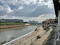
The Manggahan Floodway is an artificially constructed waterway in Metro Manila, Philippines. The floodway was built in 1986, with the cost of 1.1 billion...
13 KB (1,236 words) - 06:17, 31 August 2024

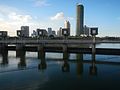
Laguna de Bay (section Manggahan floodway)
source of 15% of the Lake's water, the Marikina River (through the Manggahan Floodway), the Mangangate River, the Tunasan River, the San Pedro River, the...
35 KB (4,459 words) - 07:00, 8 September 2024

the Manggahan Floodway Manggahan Bridge (Daang Pasig Bridge) – crosses the Manggahan Floodway F B Legaspi Bridge – crosses the Manggahan Floodway Kaunlaran...
67 KB (6,532 words) - 10:30, 3 October 2024
less than 24 hours, causing the Marikina River system, including the Manggahan Floodway, to burst its banks very rapidly. It is thought that blocked pipes...
18 KB (2,141 words) - 14:54, 11 September 2024

runs between Taguig, and Taytay, Rizal, before entering Pasig. The Manggahan Floodway lessens flood conditions in Metro Manila by carrying flood waters...
49 KB (4,840 words) - 13:13, 7 October 2024
Sr. Boulevard). The overflow from the Marikina River swelled the Manggahan Floodway, flooding Pasig and Taguig and overflowing Laguna de Bay. The swelling...
24 KB (2,287 words) - 05:21, 30 July 2024

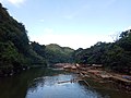
Marikina Valley, which was formed by the Marikina Fault Line. The Manggahan Floodway is an artificially constructed waterway that aims to reduce the flooding...
38 KB (3,884 words) - 12:46, 18 September 2024
namesake city of Marikina. In Pasig, the river meets the gates of the Manggahan Floodway, a controlled waterway used to prevent flooding in Manila during heavy...
27 KB (2,884 words) - 12:47, 18 September 2024
and esteros Islands Parks Beaches Slums Land reclamation Bay City Manggahan Floodway Greater Manila Area Mega Manila Government Metropolitan Manila Development...
24 KB (1,129 words) - 11:02, 25 June 2024
body of water is a major channel. List of rivers of the Philippines Manggahan Floodway River systems and other waterways in Metro Manila Filipino Aegis Society...
15 KB (125 words) - 20:18, 13 March 2024
lack of budget, which meant that only the Manggahan Floodway in Rizal province was built.: 61 The Floodway drew waters away from the Metro Manila lakeshore...
125 KB (10,355 words) - 10:43, 26 September 2024
into Laguna de Bay, has been obscured by the construction of the Manggahan Floodway, into whose East bank it now drains at the barangay of San Francisco...
6 KB (521 words) - 13:16, 9 September 2024

once linked the Marikina River with the Antipolo River before the Manggahan Floodway was built in 1986. The Parian Creek was actually connected to the...
49 KB (4,536 words) - 12:11, 3 October 2024
Highway Proposed Priority Bridges Crossing Pasig-Marikina River & Manggahan Floodway Bridges Construction Project (under China Government Facility) - 3...
28 KB (521 words) - 23:45, 4 October 2024

Napindan Bridge - which will provide additional 2 lanes crossing over Manggahan Floodway and Pasig River, respectively. Census of Population (2015). "Region...
57 KB (4,210 words) - 00:32, 29 September 2024
boundary of Marikina and Pasig cities, the river meets the gates of the Manggahan Floodway, a controlled waterway used to prevent flooding in Manila during heavy...
13 KB (1,490 words) - 13:16, 18 September 2024

and esteros Islands Parks Beaches Slums Land reclamation Bay City Manggahan Floodway Greater Manila Area Mega Manila Government Metropolitan Manila Development...
17 KB (2,017 words) - 21:31, 26 August 2024
River and Taktak River), which flows to Laguna de Bay through the Manggahan Floodway. Due to the accumulated water pollution, it was deemed unsafe for...
13 KB (1,197 words) - 07:04, 8 September 2024

where the Bridgetowne is located. It soon crosses Marikina River and Manggahan Floodway which enters the barangay of Rosario, still in Pasig. The avenue partially...
17 KB (894 words) - 07:02, 8 September 2024

and esteros Islands Parks Beaches Slums Land reclamation Bay City Manggahan Floodway Greater Manila Area Mega Manila Government Metropolitan Manila Development...
20 KB (1,610 words) - 09:33, 30 September 2024

Ketsana (Ondoy), which struck exactly 13 years prior. All gates of the Manggahan Floodway were opened to divert excess water to Laguna de Bay. The local disaster...
95 KB (8,042 words) - 02:02, 4 October 2024

populated residential and industrial area in close proximity to the Manggahan Floodway. The 8.05-hectare (19.9-acre) Bridgetowne West occupies the Quezon...
18 KB (1,811 words) - 07:32, 20 August 2024
proposal, which had first been brought up in connection with the Manggahan Floodway project. However, in a separate interview the day before, August 22...
29 KB (2,899 words) - 07:48, 24 September 2024

He has never lost in an election. He is cited for establishing the Manggahan Floodway and Parañaque spillway which alleviated flooding problem in Metro...
8 KB (578 words) - 13:29, 4 October 2024

Malate, Manila Malate Church Malonzo, Rey Mandaluyong Mangangate River Manggahan Floodway Manila Manila (province) Manila American Cemetery and Memorial Manila...
26 KB (2,420 words) - 06:10, 19 September 2024
confluence of the Marikina River and the Manggahan Floodway surrounded on three sides by the river and the village of Manggahan, Pasig. The development is situated...
12 KB (1,225 words) - 01:53, 7 April 2024

San Miguel to the south, and West Bank Road to the east, close to Manggahan Floodway and Pasig's border with the municipality of Taytay, Rizal. The park's...
7 KB (772 words) - 10:42, 19 September 2024
as Taytay National High School - Manggahan Floodway Extension. It was located along the riverside at San Juan, Floodway, Taytay, Rizal. In its first school...
5 KB (641 words) - 17:37, 10 September 2024
the Robinson Bridge and is a part of the Pasig-Marikina River and Manggahan Floodway Bridges Project, which aims to construct 12 additional bridges to...
4 KB (196 words) - 16:04, 5 May 2023