
the first bridge. Wading the Krossá River. Markarfljót gorge. Markarfljótsaurar upper flood plain. Markarfljót view from west bank towards Eyjafjallajökull...
7 KB (545 words) - 03:12, 20 August 2024

refers only to the mountain ridge between the rivers Krossá, Þröngá, and Markarfljót, but is sometimes used informally to describe a wider area that includes...
3 KB (270 words) - 21:36, 17 October 2023
and medium glacier runs (jökulhlaups) and flooding in nearby rivers Markarfljót and Holtsá [ˈhɔl̥(t)sˌauː].: 16 The eruptive phase started on 19 and...
36 KB (3,260 words) - 06:23, 21 August 2024

the Highlands of Iceland where they originate. Hvítá Krossá Kúðafljót Markarfljót Mustafl Ölfusá (the Icelandic river with the greatest flow) Rangá [ˈrauŋkˌauː]...
2 KB (124 words) - 08:42, 6 January 2023

eruption in 822 drained from the north-east aspect of the caldera down the Markarfljót river flood plain to the mountain's south-west covering an area of 600 km2...
59 KB (3,365 words) - 05:16, 9 August 2024
Krossá may refer to: Krossá (Markarfljót), a feeder of the Markarfljót Krossá (Skjálfandafljót), a feeder of the Skjálfandafljót Krossá (Bitrufjörður)...
208 bytes (51 words) - 04:05, 29 December 2019
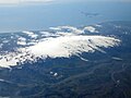
Þórólfsfell Þórólfsfell seen from the south across Markarfljót Highest point Elevation 574 m (1,883 ft) Coordinates 63°43′03″N 19°39′55″W / 63.7176°N...
1 KB (50 words) - 03:13, 20 August 2024

"slope". Fljótshlíð lies to the east of Hvolsvöllur and north of the Markarfljót river. Gunnar Hámundarson lived in the area in the 10th century. Other...
2 KB (155 words) - 10:54, 18 May 2023
no lava flowed but some ash fell. Subsequently, Lava flowed north to Markarfljót. (Part of the East volcanic zone (EVZ)) 1823 - Vatnajökull. (Part of...
220 KB (16,948 words) - 15:43, 28 July 2024
Blesá [ˈplɛːsˌauː] to the north. Hvítmaga, Gilsá and Þórólfsá drain into Markarfljót while Valá and Blesá drain into Eystri Rangá [ˈeistrɪ ˈrauŋkˌauː]. Glaciers...
10 KB (931 words) - 03:11, 20 August 2024
BP is about 4 km (2.5 mi) west of the 1477 Námshraun flow.: 388 The Markarfljöt domes formed about 3500 BP and are in the western central volcano area...
21 KB (2,335 words) - 03:10, 20 August 2024
spend a night in the open, as they were unable to cross the river of Markarfljót, before getting rescued the day after. 17 September 1944 https://aircrewremembered...
92 KB (11,448 words) - 03:21, 28 July 2024
Ytri-Rangá, but later moved eastwards and took land between "Þjórsá and Markarfljót from fell to firth, and made his home at Hof (Hofi) ". Ketils saga hœngs...
5 KB (597 words) - 09:08, 14 January 2022