
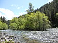
The Middle Fork Willamette River is one of several forks that unite to form the Willamette River in the western part of the U.S. state of Oregon. It is...
7 KB (507 words) - 17:19, 10 May 2020

the confluence of the Middle Fork Willamette River and the Coast Fork Willamette River near Springfield, the main stem Willamette meanders generally north...
105 KB (10,823 words) - 00:38, 16 October 2024

Fork Middle Fork Willamette River as it is officially named but frequently called North Fork of the Willamette River or North Fork of the Middle Fork...
5 KB (361 words) - 02:29, 7 January 2020

The Coast Fork Willamette River is one of two forks that unite to form the Willamette River in western Oregon in the United States. It is about 40 miles...
5 KB (287 words) - 21:03, 24 July 2020

Springfield. Formed by the confluence of the Middle Fork Willamette River and Coast Fork Willamette River near Springfield, the main stem meanders generally...
41 KB (5,128 words) - 18:21, 28 March 2024
Middle Fork River may refer to: Middle Fork River Middle Fork Cimarron River Middle Fork Eel River Middle Fork Elk River Middle Fork Feather River Middle...
511 bytes (100 words) - 00:32, 3 May 2015

Lost Creek is a tributary of the Middle Fork Willamette River in the U.S. state of Oregon. It begins in the Cascade Range foothills between Dorena Lake...
5 KB (296 words) - 08:49, 22 April 2021

Salt Creek is a 30-mile (48 km) tributary of the Middle Fork Willamette River in Lane County in the U.S. state of Oregon. It is named for salt springs...
9 KB (695 words) - 06:32, 19 August 2022

the Willamette River in the U.S. state of Oregon from the Columbia River upstream to the confluence of the Middle Fork Willamette River and Coast Fork Willamette...
28 KB (255 words) - 04:19, 27 February 2024

Fall Creek is a 34-mile (55 km) tributary of the Middle Fork Willamette River in Lane County in the U.S. state of Oregon. Beginning in the Cascade Range...
11 KB (1,019 words) - 15:08, 6 June 2024

Salt Creek Falls (category Willamette National Forest)
tributary of the Middle Fork Willamette River, that plunges into a gaping canyon in the Willamette National Forest near Willamette Pass in Lane County...
10 KB (1,116 words) - 06:03, 19 August 2022

Calapooya Mountains (category Willamette National Forest)
Willamette and Umpqua rivers. At its southeastern end, the spur joins the Cascade Range near Cowhorn Mountain near the headwaters of the Middle Fork Willamette...
7 KB (799 words) - 06:39, 17 August 2024
Calapooia; the South, Middle and North Santiam rivers to the north; the Middle Fork Willamette River to the south; and the Deschutes River to the east. Most...
25 KB (2,192 words) - 23:40, 12 October 2024

from headwaters (Confluence of Middle Fork Willamette River and Coast Fork Willamette River, OR/WA) to mouth (Columbia River, OR) Dams are listed in order...
145 KB (5,874 words) - 04:41, 7 June 2024

Waldo Lake (category Willamette National Forest)
through the area. The lake is also the source of the North Fork Middle Fork Willamette River. There are numerous alpine lakes and small mountain peaks...
9 KB (913 words) - 15:02, 2 August 2024

crossing the North Fork Middle Fork Willamette River at the south end of the Aufderheide National Scenic Byway and edge of the Willamette National Forest...
8 KB (655 words) - 19:44, 25 January 2024
Hills Creek (Oregon) (category Rivers of Lane County, Oregon)
Hills Creek is a tributary, about 16 miles (26 km) long, of the Middle Fork Willamette River in the U.S. state of Oregon. From its headwaters on Juniper Ridge...
5 KB (421 words) - 21:50, 18 March 2023
The Big River is a tributary of the Coast Fork Willamette River, approximately 12 miles (19 km) long, in western Oregon in the United States. It drains...
5 KB (346 words) - 19:49, 5 March 2021

Hills Creek Reservoir (category Rivers of Lane County, Oregon)
is an artificial impoundment behind Hills Creek Dam on the Middle Fork Willamette River in the U.S. state of Oregon. The lake is near Oakridge in Lane...
5 KB (411 words) - 14:31, 25 September 2020

are also several National Wild and Scenic Rivers within the forest. The forest is named for the Willamette River, which has its headwaters in the forest...
15 KB (1,655 words) - 01:06, 8 October 2024
Mount Hood Cleawox Lake on the coast Cougar Reservoir on the South Fork McKenzie River Crater Lake Cullaby Lake in Clatsop County Cultus Lake in Deschutes...
21 KB (209 words) - 07:22, 31 July 2024

Lowell, Oregon (category Populated places on the Willamette River)
045. The city is on the north shore of Dexter Reservoir on the Middle Fork Willamette River. The most used route to Lowell is along Lowell Bridge, a covered...
14 KB (976 words) - 01:09, 21 November 2023

Additionally the Willamette National Forest has fire crews on the Mckenzie and Middle Fork Ranger Districts. List of Oregon rivers Willamette Riverkeeper The...
8 KB (556 words) - 09:13, 31 January 2023

North Santiam River Dexter Reservoir and Dexter Dam – Middle Fork Willamette River Devils Lake – D River Dorena Reservoir - Row River Emigrant Lake –...
41 KB (3,527 words) - 10:46, 27 July 2024

River North Fork Coquille River North Fork Crooked River North Fork John Day River North Fork Malheur River North Fork Middle Fork Willamette River North...
97 KB (11,400 words) - 16:41, 4 August 2024

Long Tom River McKenzie River Mohawk River Cougar Dam and Cougar Reservoir Coast Fork Willamette River Big River Middle Fork Willamette River Lookout Point...
23 KB (1,609 words) - 19:52, 22 March 2024

Lookout Point Lake (category Willamette National Forest)
Lake (also Lookout Point Reservoir) is a large reservoir on the Middle Fork Willamette River in Lane County, Oregon, United States. It was created in 1953...
6 KB (572 words) - 17:58, 22 December 2023

On October 28, 2022, an active colony was encountered on the Middle Fork Willamette River in western Oregon. The colony is founded by a single overwintered...
19 KB (2,346 words) - 20:24, 25 August 2024

from Creswell, in the area between the Coast Fork Willamette River and the Middle Fork Willamette River. Public schools in Pleasant Hill include the OSAA...
6 KB (337 words) - 03:42, 28 July 2023

Lookout Point Dam is an earth-type dam on the Middle Fork Willamette River in the U.S. state of Oregon. It is located in Lane County. Its reservoir is...
3 KB (169 words) - 21:18, 23 December 2023