
State Route 161 (SR 161) is an east–west state highway in central Ohio. Its western terminus is in Mutual at State Route 29 and its eastern terminus is...
21 KB (1,415 words) - 19:25, 18 May 2024
Interstate 270, United States Route 23, Ohio State Route 161, and Ohio State Route 315. Interstate 71 and Ohio State Route 710 pass just to the east of...
23 KB (2,571 words) - 13:52, 25 May 2024

State Route 3 (SR 3) is a major north–south (physically northeast-southwest) highway in Ohio which leads from Cincinnati to Cleveland by way of Columbus...
20 KB (524 words) - 04:36, 29 May 2024

State Routes in Ohio are owned by the state, and maintained by the state except in cities. They are signed with a white silhouette of Ohio against a black...
191 KB (38 words) - 02:16, 1 July 2024
161 Missouri Route 161 Nevada State Route 161 New Jersey Route 161 New Mexico State Road 161 New York State Route 161 North Carolina Highway 161 Ohio...
3 KB (222 words) - 23:31, 4 April 2024

crossing most of northern Ohio. Its western terminus is at the Indiana state line near Hicksville where the route becomes Indiana State Road 37 which continues...
44 KB (1,894 words) - 17:35, 3 December 2023
state of Ohio. At about 336 miles (541 km) in length, it is the longest state route in Ohio. Its southern terminus is an interchange with U.S. Route 52...
50 KB (2,475 words) - 03:03, 9 August 2024

longest state route in Ohio. Its southern terminus is at U.S. Route 42 in Cincinnati, Ohio, and its northern terminus is at U.S. Route 6 in Sandusky, Ohio. Its...
34 KB (1,922 words) - 22:18, 4 August 2024

the northern and eastern edges of the CDP. The southern border is Ohio State Route 161 (E. Dublin Granville Road), and the southwest edge follows Alum Creek...
7 KB (549 words) - 23:43, 29 March 2024

State Route 161 is a primary state highway in and near Richmond, Virginia, United States. It extends from an interchange with Interstate 95 (I-95) in the...
18 KB (2,081 words) - 20:28, 8 February 2024

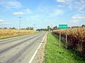
State Route 29 (SR 29) is an east–west state highway in the west-central portion of the U.S. state of Ohio. Its western terminus is at the Indiana state...
12 KB (445 words) - 19:27, 15 May 2024
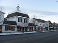
southwestern Darby Township, Union County, Ohio, United States. It is located at the intersection of State Routes 38 and 161. With a history beginning in the early...
4 KB (216 words) - 16:38, 17 March 2024

U.S. Route 33 (US 33) is a United States Numbered Highway running from near Elkhart, Indiana, to Richmond, Virginia. Within the state of Ohio, it is a...
26 KB (879 words) - 22:40, 25 August 2024

State Route 37 (SR 37) is a northwest-southeast highway (signed east–west) in Ohio. It is the ninth longest state route in Ohio. Its western terminus...
14 KB (155 words) - 19:38, 15 May 2024

State Route 605 (SR 605) is a 9.38-mile-long (15.10 km) north–south state highway in central Ohio. The southern terminus of SR 605 is at a signalized...
7 KB (553 words) - 04:21, 6 August 2023

State Route 257 (SR 257, OH 257) is a 26.19-mile (42.15 km) north - south state highway in the central portion of the U.S. state of Ohio. The highway's...
11 KB (815 words) - 08:47, 22 May 2024

State Route 745 (SR 745) is a state route in central Ohio that runs in a north-northwesterly direction along the west bank of the Scioto River. Its southern...
7 KB (521 words) - 02:40, 5 October 2023

Louisville, Kentucky to Cleveland, Ohio. The route has several names including Pearl Road from Cleveland to Medina in Northeast Ohio, Reading Road in Cincinnati...
51 KB (2,236 words) - 16:34, 31 August 2024

State Route 309 (SR 309) is an east–west highway in central Ohio. Its western terminus is at its interchange with U.S. Route 30 (US 30) near Delphos, and...
22 KB (1,254 words) - 03:11, 19 May 2024

The Ohio Turnpike, officially the James W. Shocknessy Ohio Turnpike, is a controlled-access toll road in the U.S. state of Ohio, serving as a primary...
48 KB (3,674 words) - 00:29, 30 August 2024

State Route 60 (SR 60) is a north–south state highway that runs the entire length of the U.S. state of Ohio, from the Williamstown Bridge over the Ohio...
14 KB (262 words) - 00:41, 16 May 2024

State Route 73 (SR 73) is an east–west state highway in the southern portion of the U.S. state of Ohio. Its western terminus is on U.S. Route 27 in Oxford...
15 KB (677 words) - 17:12, 30 May 2024
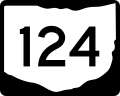
State Route 124 (SR 124) is an east–west state highway in the southern portion of the U.S. state of Ohio. Its western terminus is at State Route 134 nearly...
14 KB (703 words) - 03:02, 10 April 2023

community in Darby Township, Madison County, Ohio, United States. It is located along Ohio State Route 161, between Plain City and Dublin. Kileville was...
4 KB (165 words) - 23:55, 15 February 2024
Champaign County, Ohio, United States. It is located north of Mechanicsburg at the intersection of Ohio State Route 161, Ohio State Route 559, and Bullard-Rutan...
3 KB (84 words) - 14:42, 15 February 2024

State Route 235 (SR 235) is a 133.2-mile-long (214.4 km) north–south state highway in the western portion of the U.S. state of Ohio. Its southern terminus...
21 KB (1,192 words) - 14:07, 27 July 2024

eastern end becoming State Route 416. KML file (edit • help) Template:Attached KML/Ohio State Route 16 KML is from Wikidata "DESTAPE". Ohio Department of Transportation...
9 KB (206 words) - 15:32, 8 August 2024

State Route 710 (SR 710) is a 4.06-mile-long (6.53 km) state highway in the central portion of the U.S. state of Ohio. Existing entirely within the northern...
7 KB (480 words) - 06:28, 17 September 2023

State Route 41 (SR 41) is a north–south state highway in the southern and western portions of the U.S. state of Ohio. Its southern terminus is at U.S....
19 KB (787 words) - 19:50, 15 May 2024

State Route 56 (SR 56) is an east–west state highway in central Ohio. Its western terminus is at SR 29 near Mutual and its eastern terminus is at SR 682...
10 KB (310 words) - 01:25, 5 August 2024