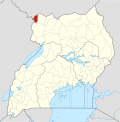
Oraba is a town in the Koboko District of the Northern Region of Uganda. The town is in the northwestern corner of Uganda, close to the international...
5 KB (303 words) - 13:57, 13 August 2021
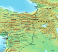
Vurra–Arua–Koboko–Oraba Road is a road in the Northern Region of Uganda, connecting the town of Vurra at the International border with the Democratic...
5 KB (399 words) - 11:09, 15 July 2024
Sudan, and the Democratic Republic of the Congo converge Vurra–Arua–Koboko–Oraba Road passes through town, in a south/north direction, intersecting with...
11 KB (575 words) - 12:59, 20 June 2024

Culiacán (section Orabá Island)
The Culiacán Botanical Garden has a variety of more than 2,000 plants. Orabá Island, as its name indicates, is an island between the confluence of the...
54 KB (5,310 words) - 21:00, 22 August 2024
1 August 2024. "Ronaldo de Jesús debutó en Cerro Porteño: "Todo el día oraba y ayer se dio" expresó emocionada su madre" [Ronaldo de Jesús debuted for...
5 KB (512 words) - 18:39, 7 August 2024
Nyamapanda Zimbabwe / Mozambique Onseepkans South Africa / Namibia Oraba Uganda / South Sudan Ouango Central African Republic / Namibia Ouésso...
54 KB (129 words) - 02:55, 25 August 2024
383°S 29.600°E / -1.383; 29.600 Africa - South/East Salia Musala, near Oraba Democratic Republic of the Congo South Sudan Uganda 3°30′N 30°52′E /...
32 KB (587 words) - 05:04, 15 June 2024

Equites Promoti indigenae, Sina Iudaeorum. Equites Sagittarii indigenae, Oraba. Equites Sagittarii indigenae, Thillazamana. Equites Sagittarii indigenae...
33 KB (3,382 words) - 18:52, 14 June 2024

passenger rail service in Uganda for many years. The Vurra–Arua–Koboko–Oraba Road passes through town, in a south–north direction. Arua is connected...
18 KB (1,059 words) - 10:14, 23 August 2024
Date Commitment Amount Civil works on the 92-km long Vurra-Arua-Koboko-Oraba Road December 1, 2009 N/A North Eastern Road-Corridor Asset Management Project...
11 KB (981 words) - 01:21, 3 October 2023
district is named after the town. Maracha is located on the Vurra–Arua–Koboko–Oraba Road, approximately 39 kilometres (24 mi), by road, north of Arua, the nearest...
4 KB (252 words) - 20:37, 16 February 2022
Aru in the DRC. It is the southernmost point along the Vurra-Arua-Koboko-Oraba Road. Vurra is the birthplace of the Ugandan international long-distance...
5 KB (293 words) - 19:59, 17 June 2021
Equites Promoti indigenae, Sina Iudaeorum. Equites Sagittarii indigenae, Oraba. Equites Sagittarii indigenae, Thillazamana. Equites Sagittarii indigenae...
8 KB (686 words) - 11:18, 11 February 2023
established in the region. During 2013, the tarmacking of the Vurra-Arua-Koboko-Oraba Road began. English. Lugbara. Kiswahili. French. Arabic. And many more local...
22 KB (2,767 words) - 21:47, 1 August 2024
Primary School Ombaci Parents Primary School Ombaci Self Help Primary School Oraba Primary School Padrombu Primary School Pamodo Primary School Pearl Primary...
8 KB (291 words) - 00:24, 4 August 2024
December 2014). "UNRA fails to Beat December Deadline for Vurra-Arua-Koboko-Oraba Road". Uganda Radio Network. Retrieved 11 July 2015. USHMU (11 May 2012)...
36 KB (2,130 words) - 10:44, 19 May 2024
in Nyadri sub-county, in Maracha District, off of the Vurra–Arua–Koboko–Oraba Road (Kaya Highway), approximately 31 kilometres (19 mi), north of Arua...
5 KB (409 words) - 05:05, 10 February 2024
ongoing. Gulu–Atiak–Nimule Road Tororo–Mbale–Soroti Road Vurra–Arua–Koboko–Oraba Road Mbarara Northern Bypass Road Kampala Northern Bypass Highway...
22 KB (1,654 words) - 06:01, 24 July 2024
Kisoro, Kibaale, Bushenyi, Jinja, Kampala, Pakwach, Nebbi, Arua, Koboko, Oraba, Gulu, Kitgum, Lira, Soroti, Katakwi, Moroto, Mbale, Iganga along with a...
39 KB (3,742 words) - 04:05, 24 August 2024
rebels to retreat from parts of Al-Qusayr, according to a rebel commander, Oraba Idris, and had captured as much as 50% of the city. SOHR also reported that...
79 KB (7,674 words) - 05:09, 22 August 2024
the town's UNLA garrison was overrun by UA forces. Terego, Maracha, and Oraba were also captured by the insurgents. By mid-October, Ugandan government...
32 KB (3,665 words) - 19:55, 22 June 2024

The left fork, called Kaya Highway continues north-westwards to Koboko, Oraba and Kaya, South Sudan. The right fork, called Rhino Camp Road continues...
10 KB (569 words) - 15:34, 2 August 2024
several towns in South Sudan bordering Uganda, including Nimule, Elegu, Oraba, Kaya and others. South Sudan will be responsible for extending the transmission...
12 KB (891 words) - 16:59, 21 July 2024
Karuma Bridge. List of roads in Uganda Transport in Uganda Vurra–Arua–Koboko–Oraba Road Felix Warom Okello (6 December 2021). "Residents decry poor state of...
5 KB (457 words) - 01:03, 7 April 2024
largest city in the country. Kaya sits directly across the border from Oraba, in Uganda. Kaya was a battle scene during the Second Sudanese Civil War...
9 KB (525 words) - 17:58, 27 July 2024
Entebbe Operation Thunderbolt (film) Opiyo Oloya Opportunity Uganda Limited Oraba Ora River Orient Bank Oropom people Osukuru Industrial Complex Osukuru Thermal...
58 KB (6,477 words) - 09:49, 29 August 2023