
complex and are occupied by government agencies. The buildings are Grade II listed. Ordnance Survey originally came to Southampton on 12 November 1841,...
12 KB (1,408 words) - 20:12, 8 May 2024

The Ordnance Survey (OS) is the national mapping agency for Great Britain. The agency's name indicates its original military purpose (see ordnance and...
84 KB (8,586 words) - 06:14, 11 August 2024

Ordnance Survey Ordnance Survey of Northern Ireland United States The National Geodetic Survey (NGS; formerly United States Coast and Geodetic Survey) The...
10 KB (1,053 words) - 15:27, 3 July 2024
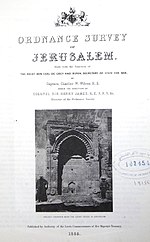
The Ordnance Survey of Jerusalem of 1864–65 was the first scientific mapping of Jerusalem, and the first Ordnance Survey to take place outside the United...
12 KB (1,579 words) - 17:18, 17 February 2023

An ordnance datum (OD) is a vertical datum used by an ordnance survey as the basis for deriving altitudes on maps. A spot height may be expressed as above...
7 KB (777 words) - 06:44, 24 August 2024
Ordnance Survey of Northern Ireland (OSNI) is the official mapping agency of Northern Ireland. The agency ceased to exist separately on 1 April 2008 when...
5 KB (667 words) - 20:07, 12 August 2023
system used by the Ordnance Survey. • "Guide to National Grid". Ordnance Survey. Retrieved 12 December 2007. • "Get-a-map". Ordnance Survey. Retrieved 17 December...
5 KB (272 words) - 14:31, 19 February 2024
The Board of Ordnance was a British government body. Established in the Tudor period, it had its headquarters in the Tower of London. Its primary responsibilities...
66 KB (8,276 words) - 09:15, 13 April 2024

reference system used by the Ordnance Survey. The "List Entry Number" is a unique number assigned to each listed building and scheduled monument by Historic...
156 KB (139 words) - 13:16, 21 August 2024
system used by the Ordnance Survey. • "Guide to National Grid". Ordnance Survey. Retrieved 12 December 2007. • "Get-a-map". Ordnance Survey. Retrieved 17 December...
10 KB (277 words) - 18:16, 23 February 2024
extract from the Ordnance Survey map at a scale of 1:2500 pinpointing the exact location of the building. D The British Listed Buildings database also includes...
44 KB (943 words) - 01:34, 24 March 2023
system used by the Ordnance Survey. • "Guide to National Grid". Ordnance Survey. Retrieved 12 December 2007. • "Get-a-map". Ordnance Survey. Retrieved 17 December...
29 KB (281 words) - 15:21, 10 July 2022

few buildings in it, and a roundabout. The buildings are sparse and are part of Elston, Offields, Osborne Newton and Nuckwell farms. Ordnance Survey: Landranger...
1 KB (69 words) - 19:22, 24 April 2022
system used by the Ordnance Survey. • "Guide to National Grid". Ordnance Survey. Retrieved 12 December 2007. • "Get-a-map". Ordnance Survey. Retrieved 17 December...
3 KB (277 words) - 16:08, 10 April 2022
OS MasterMap (category Maps from Ordnance Survey)
The OS MasterMap is the premier digital product of the Ordnance Survey. It was launched in November 2001. It is a database that records every fixed feature...
7 KB (829 words) - 23:10, 2 July 2024
system used by the Ordnance Survey. • "Guide to National Grid". Ordnance Survey. Retrieved 12 December 2007. • "Get-a-map". Ordnance Survey. Retrieved 17 December...
5 KB (277 words) - 14:03, 10 April 2022
Ordnance Survey and Bing maps/birds eye view. These are listed separately: Grade II listed buildings in Southampton: A–B Grade II listed buildings in...
37 KB (582 words) - 13:57, 17 August 2024
system used by the Ordnance Survey. • "Guide to National Grid". Ordnance Survey. Retrieved 12 December 2007. • "Get-a-map". Ordnance Survey. Retrieved 17 December...
6 KB (277 words) - 12:57, 10 April 2022
system used by the Ordnance Survey. • "Guide to National Grid". Ordnance Survey. Retrieved 12 December 2007. • "Get-a-map". Ordnance Survey. Retrieved 17 December...
3 KB (277 words) - 20:16, 29 January 2024

portal Listed buildings in Woodplumpton Ordnance Survey: Landranger map sheet 102 Preston & Blackpool (Lytham St Anne's) (Map). Ordnance Survey. 2011. ISBN 9780319228289...
2 KB (110 words) - 11:58, 30 May 2024
system used by the Ordnance Survey. • "Guide to National Grid". Ordnance Survey. Retrieved 12 December 2007. • "Get-a-map". Ordnance Survey. Retrieved 17 December...
6 KB (277 words) - 14:09, 10 April 2022
system used by the Ordnance Survey. • "Guide to National Grid". Ordnance Survey. Retrieved 12 December 2007. • "Get-a-map". Ordnance Survey. Retrieved 17 December...
4 KB (279 words) - 06:04, 7 March 2022
system used by the Ordnance Survey. • "Guide to National Grid". Ordnance Survey. Retrieved 12 December 2007. • "Get-a-map". Ordnance Survey. Retrieved 17 December...
19 KB (277 words) - 14:09, 11 August 2022
system used by the Ordnance Survey. • "Guide to National Grid". Ordnance Survey. Retrieved 12 December 2007. • "Get-a-map". Ordnance Survey. Retrieved 17 December...
14 KB (277 words) - 00:24, 5 January 2024
system used by the Ordnance Survey. • "Guide to National Grid". Ordnance Survey. Retrieved 12 December 2007. • "Get-a-map". Ordnance Survey. Retrieved 17 December...
6 KB (277 words) - 06:39, 7 March 2022

around the modern farm buildings. Ordnance Survey: Landranger map sheet 93 Middlesbrough (Darlington & Hartlepool) (Map). Ordnance Survey. 2010. ISBN 9780319228777...
1 KB (127 words) - 09:15, 22 March 2020
system used by the Ordnance Survey. • "Guide to National Grid". Ordnance Survey. Retrieved 12 December 2007. • "Get-a-map". Ordnance Survey. Retrieved 17 December...
3 KB (277 words) - 00:56, 7 February 2024
system used by the Ordnance Survey. • "Guide to National Grid". Ordnance Survey. Retrieved 12 December 2007. • "Get-a-map". Ordnance Survey. Retrieved 17 December...
4 KB (306 words) - 11:09, 7 April 2022
system used by the Ordnance Survey. • "Guide to National Grid". Ordnance Survey. Retrieved 12 December 2007. • "Get-a-map". Ordnance Survey. Retrieved 17 December...
5 KB (277 words) - 22:32, 15 August 2022
system used by the Ordnance Survey. • "Guide to National Grid". Ordnance Survey. Retrieved 12 December 2007. • "Get-a-map". Ordnance Survey. Retrieved 17 December...
11 KB (277 words) - 19:20, 14 August 2022