structure of the region of Metsovo during the early Ottoman period. In the 1454/55 census, the tax district of the timar of Metsovo (karye-i Miçova), fell...
2 KB (293 words) - 01:45, 17 April 2017
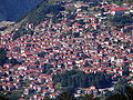
Miçova in Ottoman Turkish. In the Ottoman census records we see the word Mcwh (مجوه), which is usually pronounced "Miçova". In Aromanian, Metsovo is called...
36 KB (4,374 words) - 16:43, 29 June 2024

Aromanians (redirect from Genetic studies on Aromanians)
towns and cities such as Ioannina (Aromanian Ianina, Enina or Enãna), Metsovo (Aromanian Aminciu), Veria (Aromanian Veryia) Katerini, Trikala (Aromanian...
78 KB (7,979 words) - 14:55, 2 July 2024

Chameria (section Ottoman rule)
Chameria. An Ottoman population census held in 1908 recorded a total of 73,000 inhabitants in Chameria, of which 93% were Albanian. In Greek censuses, only Muslims...
76 KB (9,531 words) - 22:18, 14 July 2024
Aromanians in North Macedonia (section 1900 census)
group of North Macedonia numbering some 9,695 people according to the 2002 census. They are concentrated in Kruševo, Štip, Bitola and Skopje. The Aromanians...
19 KB (1,713 words) - 10:48, 11 May 2024
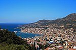
Samos (category Coordinates on Wikidata)
antiquity and is still produced on the island. The island was governed by the semi-autonomous Principality of Samos under Ottoman suzerainty from 1835 until...
51 KB (5,478 words) - 22:01, 29 July 2024
Samothrace (category Coordinates on Wikidata)
soldiers on the island. Seven soldiers of this population were Muslims. The fact that neighborhoods, which are the main features of Ottoman towns and...
16 KB (1,505 words) - 15:01, 11 August 2024

Thasos (redirect from Ottoman Thasos)
against Ottoman rule arose in 1821, at the outbreak of the Greek War of Independence, led by Hatzigiorgis Metaxas, but it failed. The Ottoman Census of 1831...
35 KB (4,029 words) - 03:55, 1 July 2024

Moscopole (category Coordinates on Wikidata)
the southern parts of Epirus, such as the settlements of Skamneli and Metsovo (Aminciu, an Aromanian settlement as well) in northwestern Greece. It was...
69 KB (7,932 words) - 15:08, 30 July 2024

Ithaca (island) (category Coordinates on Wikidata)
(Byzantine and before the Venetian period) Teaki (Venetian period) Fiaki (Ottoman period) The island has been inhabited since the 4th millennium BC. It may...
31 KB (3,539 words) - 14:52, 10 June 2024

Zagori (category Coordinates on Wikidata)
south-eastern side runs along the Varda river to Mount Mavrovouni (2,100m) near Metsovo. The municipality has an area of 989.796 km2. The population of the area...
36 KB (4,250 words) - 22:17, 8 August 2024

Alexandroupolis (category 19th-century establishments in the Ottoman Empire)
characteristic of Ottoman cities at the time. The city returned to Ottoman control by the end of the war. The brief Russian presence had a lasting effect on the design...
69 KB (6,392 words) - 03:58, 21 August 2024

Volos (category Articles containing Ottoman Turkish (1500-1928)-language text)
definitively incorporated into the Ottoman Empire. The Ottoman name of the city was Ottoman Turkish: قلز, romanized: Quluz. The Ottomans strengthened the town's...
42 KB (4,260 words) - 22:03, 7 July 2024

Larissa (category Coordinates on Wikidata)
by the Ottoman Empire in 1386/87 and again in the 1390s, but only came under permanent Ottoman control in 1423, by Turahan Bey. Under Ottoman rule, the...
49 KB (4,259 words) - 11:58, 5 August 2024

Conference of 1912–13 as a minority group within Albania. They fought the Ottoman Empire alongside the Serbians and Greeks during the Balkan Wars. During...
23 KB (2,316 words) - 05:17, 27 July 2024

Hydra (island) (category Coordinates on Wikidata)
admiral Andreas Miaoulis, himself a settler on Hydra, used Hydriot fire ships to inflict heavy losses on the Ottoman fleet. Eventually the fleet of Hydra -...
39 KB (4,371 words) - 23:40, 4 August 2024

Kruševo (category Coordinates on Wikidata)
Stefan Uroš V) held the region. The principality and region came under Ottoman Turkish rule in 1395. A large part of the Macedonian population in Kruševo...
24 KB (2,001 words) - 18:27, 1 July 2024

Konitsa (category Coordinates on Wikidata)
Filat (Philiates), Meçova (Metsovo), Leskovik (war kurzzeitig Sancak) und Koniçe (Konitsa) Kemal Karpat (1985), Ottoman Population, 1830–1914, Demographic...
30 KB (3,232 words) - 16:13, 16 May 2024

Corfu (category Coordinates on Wikidata)
Ottomans. A series of attempts by the Ottomans to take the island began in 1431 when Ottoman troops under Ali Bey landed on the island. The Ottomans tried...
181 KB (20,451 words) - 13:14, 21 August 2024

Kalamata (category Coordinates on Wikidata)
along the Nedon River at the head of the Messenian Gulf. The 2021 census recorded 72,906 inhabitants for the wider Kalamata Municipality, of which 66...
40 KB (3,621 words) - 09:21, 11 August 2024

Language and Culture in Germany. On a visit to Metsovo, Epirus in 1998, Greek President Konstantinos Stephanopoulos called on Vlachs to speak and teach their...
50 KB (3,955 words) - 22:05, 5 August 2024

Mytilene (category Coordinates on Wikidata)
attacked Ottoman and Barbary flagships. Resulting in a victory for the Venetians. Mytilene along with the rest of Lesbos remained under Ottoman control...
42 KB (3,747 words) - 11:25, 20 August 2024

Kavala (category Coordinates on Wikidata)
the late Roman (1st - 6th century AD) aqueduct. The Ottomans also extended the Byzantine fortress on the hill of Panagia. Both landmarks are among the most...
49 KB (4,732 words) - 20:30, 15 June 2024

Trikala (category Coordinates on Wikidata)
000 inhabitants, with the last Ottoman census in 1877/8 listing 25,000 inhabitants for the entire sanjak of Trikala. On 23 August 1881 with the Treaty...
30 KB (3,119 words) - 06:06, 29 July 2024

Aegina (category Coordinates on Wikidata)
During the early part of the Ottoman–Venetian War of 1714–1718 the Ottoman Fleet commanded by Canum Hoca captured Aegina. Ottomans rule in Aegina and the Morea...
60 KB (7,240 words) - 15:22, 16 June 2024

Kozani (category Coordinates on Wikidata)
century, Kozani was part of the Manastir Vilayet of the Ottoman Empire. In the 1881–1893 census, the kaza of Kozana had a total population of 27,652; consisting...
39 KB (3,397 words) - 14:27, 27 May 2024
Greek bands on the Ottoman Empire began to persecute and attack the Aromanians, with instances of killings of Aromanian priests or of attacks on entire Aromanian...
14 KB (1,437 words) - 13:46, 28 March 2024

Kythira (category Coordinates on Wikidata)
1799, the Ionian islands became the Septinsular Republic, nominally under Ottoman suzerainty, but in practice dominated by Imperial Russia. In 1807, the...
31 KB (3,498 words) - 12:23, 4 July 2024

Gytheio (category Coordinates on Wikidata)
was abandoned. It remained a small village throughout the Byzantine and Ottoman times. Its importance grew when Tzannetos Grigorakis built his tower at...
15 KB (1,654 words) - 11:48, 6 July 2024

Souli (category Coordinates on Wikidata)
locals is recorded. According to this, the first settlers of Souli were shepherds who came from a village called Gardiki trying to avoid the Ottoman oppression...
6 KB (636 words) - 00:15, 9 July 2024