
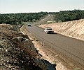
The Plenty Highway is a 498-kilometre (309 mi) outback mostly unsealed road in the Northern Territory of Australia between the Stuart Highway and north-western...
6 KB (415 words) - 17:44, 8 November 2022

Hart Range, Northern Territory (redirect from Plenty River (Northern Territory))
Range, is a town in the Northern Territory of Australia located on the Plenty Highway 215 km (134 mi) by road northeast of Alice Springs. It is also the name...
8 KB (826 words) - 03:47, 21 January 2025
Sūrat al-Kawthar in the Quran Plenty (brand), a brand of paper towel sold in the UK Plenty Highway, in Australia Plenty, a vertical farming company This...
1 KB (232 words) - 14:57, 4 November 2024

Highway 1 along either coast. Roads that make up the highway are: Great Central Road Gunbarrel Highway Lasseter Highway Stuart Highway Plenty Highway...
9 KB (310 words) - 05:03, 11 February 2024

Barkly Highway at Tennant Creek. The highway continues 508 km (316 mi) south into Alice Springs passing the Plenty Highway. It passes through the Macdonnell...
34 KB (2,643 words) - 06:39, 15 February 2025
Plenty Valley Highway is a 9 kilometres (6 mi) highway with a mix of two arterial roads in northern Melbourne, Australia. The Plenty Valley Highway, a...
3 KB (127 words) - 17:44, 11 January 2025

identifying important through-routes. The Northern Territory's National Highways are the main routes connecting Darwin to the adjacent states of Queensland...
24 KB (541 words) - 09:41, 31 March 2024

The Sandover Highway is an outback unsealed track in the Northern Territory between the Plenty Highway north of Alice Springs and the Northern Territory/Queensland...
5 KB (391 words) - 13:13, 27 October 2024

property including Field River, Manners Creek and Marqua Creek. The Plenty Highway passes through the northern end of the station near to the homestead...
6 KB (613 words) - 03:27, 22 January 2025

The Bay of Plenty region, officially the Bay of Plenty Region, is a local government region in the North Island of New Zealand. Also called just the Bay...
34 KB (3,010 words) - 09:21, 22 February 2025

Tobermorey, a town with 20 inhabitants. From here the trail continues as the Plenty Highway towards Alice Springs. The route is mostly unpaved and marked by corrugations...
5 KB (343 words) - 13:40, 20 June 2023
as a highway, but without a highway name. For example, Great Southern Highway is classified as a main road, not as a highway, or Hereward Highway in the...
24 KB (406 words) - 04:35, 7 February 2025

Highway (A36) Buntine Highway (B96) Carpentaria Highway (B1) Central Arnhem Road (C24) Kakadu Highway (A21/B21) Lasseter Highway (B4) Plenty Highway (State...
4 KB (297 words) - 22:07, 27 December 2023

Lasseter Highway Oodnadatta Track Peninsula Developmental Road Plenty Highway Sandover Highway Strzelecki Track Talawana Track Tanami Track Although the desert...
66 KB (6,494 words) - 02:40, 28 February 2025
Mulga Bore Football Club Nyirripi Football Club Pioneers Football Club Plenty Highway Football Club Rovers Football Club South Football Club Ti Tree Football...
80 KB (5,357 words) - 23:32, 26 January 2025

State Highway 29 (SH 29) is a New Zealand state highway that travels over the Kaimai Ranges linking the Bay of Plenty and Waikato regions. For most of...
15 KB (1,289 words) - 23:41, 6 February 2025

property at the south eastern end. The property is very close to the Plenty Highway, which almost intersects the north west corner. In June 2011 the 4,410 km2...
4 KB (359 words) - 03:24, 22 January 2025

Plenty Rd to link up with Eastern Freeway between Bulleen Road and Burke Road, via the Banyule Flats Reserve. In recent years, Greensborough Highway has...
18 KB (1,463 words) - 00:00, 24 June 2024
its name, flows through the property at the north eastern end. The Plenty Highway almost bisects the property from west to east. The lease is just under...
3 KB (281 words) - 12:16, 7 August 2023
initially in respect to land described as NT Portion 1815 located on the Plenty Highway and previously used as an “Animal Industry Branch research block.” The...
6 KB (408 words) - 01:00, 16 August 2024
(proposed) Plenty Highway Mallee Highway South Gippsland Highway Inntal Autobahn Републикански път I-12 Alberta Highway 12 British Columbia Highway 12 Manitoba...
10 KB (692 words) - 05:13, 27 January 2025

State Highway 30 (SH 30) is a New Zealand state highway, linking the Waikato and Bay of Plenty towns of Te Kūiti, Mangakino, Rotorua, and Whakatāne. At...
9 KB (592 words) - 11:05, 16 January 2025

Rotorua (redirect from Rotorua, Bay of Plenty)
Rotorua (Māori: [ˌɾɔtɔˈɾʉa]) is a city in the Bay of Plenty region of New Zealand's North Island. It is sited on the southern shores of Lake Rotorua, from...
68 KB (5,757 words) - 03:22, 3 February 2025
Program in Central Australia, working in remote communities along the Plenty Highway to support the mothers and grandmothers whose young people are engaged...
22 KB (2,611 words) - 11:08, 10 March 2024

State Highway 2 (SH 2) runs north–south through eastern parts of the North Island of New Zealand from the outskirts of Auckland to Wellington. It runs...
25 KB (2,121 words) - 21:58, 29 December 2024
State Highway 33 (SH 33) is a New Zealand state highway in the Bay of Plenty in the North Island. It is one of two state highways (along with SH 36) that...
2 KB (234 words) - 10:15, 8 September 2024
(126 mi) long. Highway 600 intersects Highway 18, Highway 361, Highway 13, Highway 48, Highway 1, Highway 709, Highway 308, and Highway 8. Highway 600 passes...
72 KB (5,422 words) - 19:38, 15 January 2025

Ōmokoroa (redirect from Tawhitinui Marae, Bay of Plenty)
within the Kaimai Ward, Western Bay of Plenty. Ōmokoroa includes the urban area on the harbour side of State Highway 2, along with Youngson Road to Plummers...
12 KB (1,082 words) - 06:59, 4 October 2024
Diamantina Developmental Road (redirect from Boulia Mount Isa Highway)
section from Boulia to Mount Isa is also known as the Boulia Mount Isa Highway and the section from Bedourie to Boulia is also known as the Boulia Bedourie...
11 KB (502 words) - 03:05, 28 June 2024
bw-11m May 9, 1946 World Food Problems; video [732] Productivity, Key to Plenty J. Fredeic Dewhurst bw-11m March 28, 1949 video [733] The Progressive Era:...
327 KB (283 words) - 13:56, 15 January 2025