
Route 138 is a major highway in the Canadian province of Quebec, following the entire north shore of the St. Lawrence River past Montreal to the temporary...
42 KB (1,545 words) - 10:29, 16 July 2024

Chemin du Roy (redirect from Chemin du Roi (Quebec))
the present-day Quebec Route 138. The expressway that replaces both Route 138 and the Chemin du Roy through most of its course is Quebec Autoroute 40. In...
5 KB (390 words) - 16:23, 3 July 2024

Port-Cartier (redirect from Port Cartier, Quebec)
17389) are also within its municipal boundaries, all located along Quebec Route 138. In 1915, Colonel Robert R. McCormick, owner of the Chicago Tribune...
14 KB (1,079 words) - 02:05, 8 June 2024

Jacques Cartier Bridge to the end of the highway at Sherbrooke Street (Quebec Route 138) in Montreal, the highway is a one-way pair formed by Papineau Avenue...
5 KB (152 words) - 16:58, 18 April 2023

Trans-Labrador Highway (redirect from Newfoundland and Labrador Route 500)
highways Newfoundland-Labrador fixed link Newfoundland and Labrador Route 516 Quebec Route 138 Careen, Evan. "Funding announced for Trans-Labrador Highway |...
26 KB (1,552 words) - 21:08, 14 July 2024

Quebec's Route 389 connects Route 138 adjacent to Baie-Comeau with the Newfoundland and Labrador border, connecting with the Trans-Labrador Highway (Newfoundland...
10 KB (940 words) - 18:49, 22 June 2024
Highway 138 may refer to: Ontario Highway 138 Prince Edward Island Route 138 Quebec Route 138 National Route 138 National Highway 138 (India) Japan National...
4 KB (272 words) - 13:37, 23 June 2024

La Haute-Côte-Nord Regional County Municipality (redirect from La Haute-Côte-Nord County Regional Municipality, Quebec)
Saguenay River, all places and municipalities of the RCM are along Quebec Route 138 directly on the shores of the St. Lawrence River. The unorganized territory...
7 KB (333 words) - 15:24, 24 June 2024

Kegashka (redirect from Kegaska, Quebec)
reachable by road without passing through Newfoundland and Labrador. Quebec Route 138 reached the community on September 26, 2013, with the inauguration...
10 KB (1,001 words) - 16:46, 11 October 2023
Road signs in Canada (section Quebec road signs)
Steep downgrade, with slope given as a percentage. Used on Quebec Route 138 between Quebec City and La Malbaie and elsewhere This sign is used at all...
21 KB (1,998 words) - 15:58, 23 July 2024
Tadoussac (redirect from Tadoussac, Québec)
of Quebec Route 138 and the main link to Sept-Îles. The village is considered the gateway to the Manicouagan region. Bus service to and from Quebec City...
15 KB (1,239 words) - 16:08, 15 July 2024

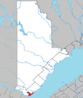
Sainte-Anne-de-la-Pérade (redirect from La Perade, Quebec)
of Quebec in Canada. The town is located near the mouth of the Sainte-Anne River along the Chemin du Roy, a historic segment of Quebec Route 138 that...
12 KB (786 words) - 11:39, 21 June 2024

on the Chemin du Roy, a historic segment of Quebec Route 138 that stretches from near Montreal to Quebec City. The town is also close by to A-40, where...
11 KB (730 words) - 09:13, 12 January 2024

Pointe-aux-Trembles in the east, where it intersects with Sherbrooke Street (Quebec Route 138). Through most of its length, it parallels the Riviere des Prairies...
4 KB (336 words) - 16:50, 7 July 2024

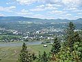
province of Quebec, located in La Côte-de-Beaupré Regional County Municipality. The town is along the Saint Lawrence River and Route 138 at the mouth...
8 KB (507 words) - 03:06, 28 January 2023
Charlevoix (redirect from Charlevoix, Quebec)
are important institutions for environmental education in the area. Quebec Route 138 is the major highway through the region, which closely follows the...
11 KB (898 words) - 14:13, 14 February 2024
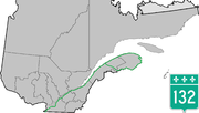
Route 132 is the longest highway in Quebec. It follows the south shore of the Saint Lawrence River from the border with the state of New York in the hamlet...
37 KB (580 words) - 14:23, 9 March 2024
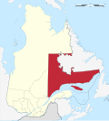
Côte-Nord (redirect from Northern Shore of Quebec)
of this region. Quebec Route 138 (The Whale Route), from Tadoussac to Blanc-Sablon Rivière-au-Tonnerre, village-relais Maritime Quebec Between nature and...
33 KB (2,864 words) - 14:06, 26 July 2024
Ontario–Quebec border, where it continues as Highway 417 towards Ottawa; the eastern terminus is in Boischatel, where it transitions into Route 138 at the...
30 KB (638 words) - 20:53, 21 April 2024
Route 2 was a previous number used for a major highway in the Canadian province of Quebec. The highway stretched from the Ontario border at Rivière-Beaudette...
7 KB (400 words) - 04:17, 19 June 2023

(La Ferme, Sainte-Martine, QC)) – a residential area located along Quebec Route 138. Le Domaine-de-la-Pêche-au-Saumon (45°15′15″N 73°47′55″W / 45.25417°N...
13 KB (762 words) - 04:11, 2 May 2024

Quebec, Canada. It is located at the mouth of the Godbout River on the north shore of the St. Lawrence River. Godbout is accessible via Quebec Route 138...
14 KB (1,011 words) - 14:10, 20 June 2024

Le Golfe-du-Saint-Laurent Regional County Municipality (redirect from Le Golfe-du-Saint-Laurent Regional County Municipality, Quebec)
Blanc-Sablon, all communities are only accessible by boat or plane, although Quebec Route 138 is being planned to extend all along the coast. Since the early 1990s...
13 KB (654 words) - 16:37, 5 June 2024

Baie-Johan-Beetz (redirect from Baie Johan Beetz, Quebec)
In 1996, Quebec Route 138 (The Whale Route) was extended to Havre-Saint-Pierre, thus connecting the village of Baie-Johan-Beetz to the Quebec road network...
30 KB (2,211 words) - 10:21, 27 July 2024

"Quebec Route 158" (Map). Google Maps. Google. Retrieved May 12, 2023. The H.M. Gousha Company (1955). "Québec" (Map). Shell Map of Quebec and Maritime...
8 KB (243 words) - 21:47, 29 May 2023

Baie-Sainte-Catherine (redirect from Baie-Sainte-Catherine, Quebec)
service across the Saguenay River to Tadoussac. The ferry is part of Quebec Route 138 which is the main land link to Sept-Îles along the Côte-Nord. Baie-Sainte-Catherine...
9 KB (512 words) - 03:05, 28 January 2023

municipality on January 1, 1990. All three communities are accessible via Quebec Route 138 from Blanc-Sablon to the east only; this road currently ends at Vieux-Fort...
16 KB (1,210 words) - 09:11, 5 May 2024
Mingan (redirect from Ekuantshit, Quebec)
Municipality (administratively not part of it), Quebec, Canada. The reserve is accessible via Quebec Route 138, 10 kilometers (6.2 mi) east of the village...
10 KB (823 words) - 14:15, 6 July 2024

France/Lower Canada. It was later incorporated as Quebec Route 2 and is now part of Quebec Route 138. Two notable post roads built in the late 1700s and...
6 KB (611 words) - 02:38, 18 April 2024
National Highway System (Canada) (section Quebec)
roadway designated under one of three classes: Core Routes, Feeder Routes, and Northern and Remote Routes. The Government of Canada maintains very little...
74 KB (1,269 words) - 10:55, 27 May 2024