
Fuy River (Spanish: Río Fuy) is a river in the commune of Panguipulli, southern Chile. It drains Pirihueico Lake and flows southward along the village...
2 KB (122 words) - 03:10, 6 June 2022
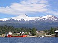
Puerto Fuy is a Chilean village (Spanish: aldea) in Panguipulli commune, of Los Ríos Region. Puerto Fuy lies along the 203-CH route to Huahum Pass into...
3 KB (71 words) - 14:33, 29 March 2017
River Rio FuyFui River • 39°49′18″S 72°00′43″W / 39.82167°S 72.01186°W / -39.82167; -72.01186 (Río Fuy) • 3889220 • STM Rio Hua HumRío Hua...
50 KB (5,045 words) - 17:00, 10 May 2023

Huilo-Huilo Biological Reserve (category Protected areas of Los Ríos Region)
travel through the Hua Hum Pass. After leaving Chile route 203 in Puerto Fuy, one must board the Barcaza Hua Hum a ferry that crosses Pirihueico Lake...
8 KB (820 words) - 06:27, 15 August 2024

Panguipulli Futrono Río Bueno Lago Ranco La Unión Corral Paillaco Valdivia Máfil Lanco Mariquina Los Lagos In the last census, of 2017, Los Ríos Region (then...
24 KB (2,037 words) - 04:48, 15 August 2024
compiled from the data supplied by GeoNames. It includes all features named "Rio", "Canal", "Arroyo", "Estero" and those whose Feature Code is associated...
124 KB (143 words) - 23:27, 16 February 2024
Molco Airport (category Airports in Los Ríos Region)
Choshuenco, a small lakeside town in the Los Ríos Region of Chile. The airport is near the mouth of the Fuy River at the eastern end of Panguipulli Lake...
2 KB (119 words) - 12:43, 26 March 2023
Neltume River (category Rivers of Los Ríos Region)
(Spanish: Río Neltume) is a river in the commune of Panguipulli, southern Chile. It drains Neltume Lake and flows southward where it joins Fuy River and...
1,014 bytes (61 words) - 20:38, 3 August 2023

enables travelers to cover the distance from Puerto Pirihueico to Puerto Fuy, as there are no roads in this area. Public transportation includes a bus...
27 KB (2,483 words) - 18:20, 31 July 2024
Puerto Pirihueico (category Los Ríos Region geography stubs)
terminal station of the ferry that crosses the lake connecting to Puerto Fuy. Geologically Puerto Pirihueico is placed on top of Holocene sediments on...
3 KB (88 words) - 14:36, 29 March 2017

To get from one side of Pirihueico Lake to the other, the town of Puerto Fuy, nearly half an hour by car east of Panguipulli, operates a ferry that crosses...
9 KB (671 words) - 07:51, 5 December 2023
Hua Hum Pass (category Landforms of Los Ríos Region)
to Puerto Fuy, on the other side of Pirihueico Lake. The ferry ride lasts approximately 2 hours. It is the main pass of the Chilean Los Ríos Region to...
2 KB (211 words) - 06:46, 15 August 2024

Pirihueico Lake (category Lakes of Los Ríos Region)
nearby Huahum Pass. For that reason there is a ferry operating between Puerto Fuy and Puerto Pirihueico in the western respectively eastern extreme of the...
2 KB (137 words) - 06:39, 15 August 2024