The River Lathkill is a river in the Peak District National Park in Derbyshire, England. First recorded in 1280, the name "Lathkill" possibly has Scandinavian...
7 KB (529 words) - 18:56, 30 October 2023
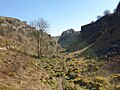
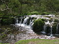
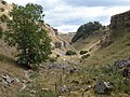
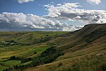
Lathkill Dale is the valley of the River Lathkill near Bakewell, Derbyshire in the Peak District of England. The river emerges into the dale from springs...
8 KB (907 words) - 19:07, 27 September 2023

the River Derwent at Rowsley. The main tributary of the river is the River Lathkill, which enters approximately one mile from its mouth. The River Wye...
6 KB (477 words) - 08:29, 1 October 2022

is on Gratton Moor and after passing below Youlgreave it joins the River Lathkill at Alport. Less than 4 miles (7 km) in length, its waters are very clear...
2 KB (187 words) - 17:28, 6 May 2021

Bakewell, south of the B5055 road. Over Haddon overlooks Lathkill Dale and the River Lathkill, which may be crossed by a clapper bridge on a footpath running...
5 KB (351 words) - 22:13, 24 August 2023

as River Eye) River Sence (R) River Derwent (L) River Ecclesbourne (R) River Amber (L) Bentley Brook (L) (near Matlock) River Wye (R) River Lathkill (R)...
87 KB (10,761 words) - 08:18, 16 June 2024
Langwith Langwith Bassett Langwith Colliery Langwith Junction Larklands Lathkill Dale Laund Hill Lea Bridge Lea Hall Lea & Holloway Leabrooks Leaden Knowl...
24 KB (1,553 words) - 16:16, 27 December 2023
structures, a former cotton mill and sluice gate, a footbridge over the River Lathkill, a house, a church, and a telephone kiosk. Map all coordinates using...
9 KB (359 words) - 13:01, 25 September 2023

National Park. From Rowsley, it follows the River Wye, meeting the B5056 near the endpoint of the River Lathkill. It passes Haddon Hall and enters Bakewell...
35 KB (4,466 words) - 12:49, 9 July 2024
across the River Wear Crossings of the River Severn Category:Crossings of the River Tees Category:Crossings of the River Tyne Crossings of the River Thames...
69 KB (258 words) - 17:12, 13 July 2024

England. It lies east of Youlgreave, at the confluence of the River Bradford and the River Lathkill. The oldest house in the hamlet is Monks Hall. There also...
3 KB (266 words) - 16:51, 22 March 2023
for recreation. The dales are: Lathkill Dale (53°11′19″N 1°43′33″W / 53.1886°N 1.7257°W / 53.1886; -1.7257 (Lathkill Dale)) Cressbrook Dale (53°15′42″N...
3 KB (391 words) - 19:43, 11 April 2022
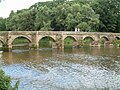
associated structures in the gardens and grounds. The River Wye and its tributary, River Lathkill, flow through the parish, and bridges crossing them are...
17 KB (552 words) - 13:57, 7 November 2022
Wye River Lathkill River Bradford River Noe River Ashop River Alport River Westend River Dove River Manifold River Hamps River Tame River Blythe River Cole...
37 KB (2,466 words) - 05:06, 10 February 2024
Retrieved 5 April 2020. Historic England. "Coal Pit Bridge over the River Lathkill, Youlgreave (Grade II) (1334999)". National Heritage List for England...
97 KB (4,138 words) - 09:44, 1 May 2024
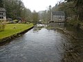
-1.66882 (Alport Mill) 18th century A former corn watermill by the River Lathkill, it is in limestone and gritstone, with gritstone dressings, quoins...
8 KB (313 words) - 15:38, 10 July 2022

that was 10 metres (33 ft) wide. Conksbury medieval bridge over the River Lathkill is a designated Grade II listed structure. The bridge was built in the...
4 KB (455 words) - 10:02, 8 October 2022

(892 ft) above sea level. The River Bradford flows along the northern edge of the moor past Youlgreave and into the River Lathkill at Alport. Harthill Moor...
8 KB (981 words) - 19:17, 14 July 2024

towards the head of Lathkill Dale near Monyash, Derbyshire, in the Peak District of England. Cales Dale is included within Lathkill Dale as part of the...
6 KB (537 words) - 20:00, 13 July 2024

Haddon. Nether Haddon is centred on the River Wye north-west of the confluence of the tributary the River Lathkill, which marks part of the southern boundary...
4 KB (447 words) - 20:08, 27 March 2023

Valley is the limestone valley of the River Wye in the White Peak of Derbyshire, England. The source of the River Wye is west of Buxton on Axe Edge Moor...
14 KB (1,476 words) - 12:08, 7 May 2023
at Alport Smelt Mill to the very north of the parish alongside the Lathkill river, which was in use between 1845 and 1875 and the operations controlled...
17 KB (1,846 words) - 22:45, 8 February 2024
(passing under the viaduct which carries the Monsal Trail and crossing the River Wye). It then crosses the A6 near the Waterloo Inn and over Taddington Moor...
8 KB (860 words) - 15:29, 3 September 2023

manages the reserve which covers five separate dales of the White Peak (Lathkill Dale, Cressbrook Dale, Hay Dale, Long Dale and Monk’s Dale). It is also...
9 KB (953 words) - 16:46, 27 July 2022

Carboniferous plateau. It stands on the hillside above the confluence of Lathkill Dale and Bradford Dale. To the east, the geology is shale-like rather than...
14 KB (1,313 words) - 17:09, 1 July 2024
the River Lathkill, Youlgreave (1334999)", National Heritage List for England, retrieved 6 January 2023 Historic England, "Packhorse Bridge over River Bradford...
54 KB (1,382 words) - 12:11, 13 August 2024

Inn in Leadmill, was built in the 16th century. Leadmill Bridge over the River Derwent dates from the late 18th century where it replaced a ford, and was...
16 KB (1,712 words) - 17:27, 27 September 2023
introduced to smelt lead ore on an industrial scale. Magpie Mine near Bakewell, Lathkill Dale mines and the Beans and Bacon mine near Bonsall adopted innovative...
25 KB (2,736 words) - 04:55, 16 August 2024
Peak District (section Rivers, reservoirs and canals)
on grassland, light woodland, screes and rock ledges, and by streams in Lathkill, Wolfscote, Taddington, Wye Dale and other dales. Pollen evidence from...
121 KB (11,666 words) - 12:07, 27 July 2024
passing through Hallfield Gate, Higham and Mickley. The River Amber is a subsidiary of the River Derwent, it forms much of the parish south western boundary...
45 KB (5,178 words) - 13:11, 10 June 2024