Augmentation of a global navigation satellite system (GNSS) is a method of improving the navigation system's attributes, such as precision, reliability...
14 KB (1,505 words) - 00:10, 20 April 2024

Civil Aviation Organization (ICAO) calls this type of system a satellite-based augmentation system (SBAS). Europe and Asia are developing their own SBASs:...
42 KB (4,018 words) - 08:47, 20 September 2024

Satellite System (GLONASS), China's BeiDou Navigation Satellite System (BDS), and the European Union's Galileo. Satellite-based augmentation systems (SBAS)...
43 KB (4,447 words) - 14:47, 20 September 2024

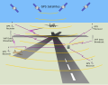
Multi-functional Satellite Augmentation System (MTSAT or MSAS) is a Japanese satellite based augmentation system (SBAS), i.e. a satellite navigation system which...
3 KB (228 words) - 15:19, 5 May 2024

Satellite System (QZSS), also known as Michibiki (みちびき), is a four-satellite regional satellite navigation system and a satellite-based augmentation system...
22 KB (1,872 words) - 13:56, 7 September 2024
BeiDou (redirect from BeiDou Satellite-based Augmentation System)
Navigation Satellite System (BDS; Chinese: 北斗卫星导航系统; pinyin: běidǒu wèixīng dǎoháng xìtǒng) is a satellite-based radio navigation system owned and operated...
66 KB (5,740 words) - 17:39, 14 September 2024

Differential GPS (redirect from Differential satellite navigation)
from orbiting satellites instead of ground-based transmitters is called a Wide-Area DGPS (WADGPS) satellite-based augmentation system. When GPS was first...
26 KB (2,911 words) - 00:09, 7 September 2024

European Geostationary Navigation Overlay Service (redirect from European geostationary navigation overlay system)
European Geostationary Navigation Overlay Service (EGNOS) is a satellite-based augmentation system (SBAS) developed by the European Space Agency and EUROCONTROL...
18 KB (1,763 words) - 16:16, 30 September 2024
The local-area augmentation system (LAAS) is an all-weather aircraft landing system based on real-time differential correction of the GPS signal. Local...
12 KB (1,415 words) - 04:32, 6 March 2024
Augmentation Network (SouthPAN) is a joint initiative of the Australian and New Zealand Governments that provides satellite-based augmentation system...
3 KB (276 words) - 18:33, 18 March 2024
GPS-aided GEO augmented navigation (category Satellite-based augmentation systems)
an implementation of a regional satellite-based augmentation system (SBAS) by the Government of India. It is a system to improve the accuracy of a GNSS...
24 KB (2,664 words) - 13:06, 17 August 2024
The Global Positioning System (GPS), originally Navstar GPS, is a satellite-based radio navigation system owned by the United States government and operated...
178 KB (18,555 words) - 16:14, 27 September 2024
OmniSTAR (category Global Positioning System)
OmniSTAR is a satellite-based augmentation system (SBAS) service provider. OmniSTAR correction signals are proprietary, and a subscription must be bought...
3 KB (331 words) - 06:30, 4 August 2024

The Maneuvering Characteristics Augmentation System (MCAS) is a flight stabilizing feature developed by Boeing that became notorious for its role in two...
94 KB (10,064 words) - 21:34, 22 August 2024

Geostationary orbit (redirect from Geostationary satellite)
1038/d41586-018-02630-w. PMID 29517031. "Satellite Navigation – WAAS – How It Works". FAA. June 12, 2019. "Satellite Based Augmentation System test-bed project". Geoscience...
49 KB (4,861 words) - 05:05, 11 June 2024

The System for Differential Corrections and Monitoring (SDCM), is the satellite-based navigation augmentation system operated by Russia's Roscosmos space...
2 KB (122 words) - 22:20, 26 September 2023
Global air-traffic management (category Satellite navigation systems)
in combination with future core constellations and augmentation systems. Signals from core satellite are received by ground reference stations and any...
3 KB (372 words) - 14:55, 5 May 2024
Hemisphere GNSS (category Satellite-based augmentation systems)
designs and manufactures precision global positioning system and global navigation satellite system products and technology for positioning, heading, guidance...
5 KB (355 words) - 06:20, 23 October 2023

owner; an 'open range' system, where augmentations are allowed unless forbidden by the owner; and a 'freedom to roam' system, where real property owners...
16 KB (1,785 words) - 04:55, 15 September 2024
GLONASS (redirect from GLObal NAvigation Satellite System)
"Current and planned global and regional navigation satellite systems and satellite-based augmentation systems" (PDF). Archived (PDF) from the original on 2...
71 KB (6,187 words) - 17:49, 29 September 2024
Paksat-MM1R (category Communications satellites)
communications, high-throughput broadband and the Satellite-Based Augmentation System (SBAS) services etc. The satellite will be positioned at 38.2° E orbit slot...
5 KB (429 words) - 09:37, 24 September 2024

ionospheric data are transmitted via satellite in Satellite Based Augmentation Systems (SBAS) such as Wide Area Augmentation System (WAAS) (available in North America...
37 KB (5,015 words) - 13:06, 27 August 2024
of augmentations such as satellite-based augmentation systems (SBAS), ground-based augmentation systems (GBAS) and ground-based regional augmentation systems...
18 KB (2,433 words) - 04:44, 6 March 2024

Wide Area Augmentation System (WAAS) Wragg, David W. (1973). A Dictionary of Aviation (1st ed.). Osprey. p. 143. ISBN 9780850451634. "Satellite Navigation...
52 KB (6,179 words) - 10:29, 8 September 2024
RINEX (category Satellite navigation)
GLONASS, Galileo, Beidou, along with data from EGNOS and WAAS satellite based augmentation systems (SBAS), QZSS, simultaneously. RINEX version 3.02 was submitted...
7 KB (651 words) - 03:19, 6 September 2024
Wide Area GPS Enhancement (category Satellite-based augmentation systems)
would be available for each satellite, resulting in increased horizontal accuracy. Potential improvements to the system include simplifying the upload...
3 KB (421 words) - 10:41, 14 July 2024

European Union (category Political systems)
European Geostationary Navigation Overlay Service (EGNOS) is a satellite-based augmentation system (SBAS) developed by the ESA and EUROCONTROL. Currently, it...
270 KB (23,609 words) - 08:02, 19 September 2024

System, Built-In Terrain Awareness and Warning System (TAWS), Class-B Dual Inertial Reference System Dual Global Positioning System/Satellite-Based Augmentation...
38 KB (3,718 words) - 21:02, 30 May 2024

GSAT (redirect from List of GSAT satellites)
GSAT satellites manufactured by ISRO have been launched, out of which 14 are in service. The GSAT series of geosynchronous satellites is a system developed...
22 KB (517 words) - 17:12, 20 August 2024

install MLS have instead published ground-based augmentation system (GBAS) approaches. As more GBAS system are installed, then the further installation...
18 KB (2,263 words) - 08:32, 25 August 2024