
The Shabakty (Kazakh: Шабақты; Russian: Шабакты) is a river in southern Kazakhstan. It has a length of 164 km (102 mi) and a drainage basin of 1,290 km2...
4 KB (276 words) - 17:12, 28 March 2024

Kishi Shabakty (Kazakh: Кіші Шабақты; Russian: Малое Чебачье, Maloye Chebachye —"Small Chebachye") is a lake in Burabay District, Akmola Region, Kazakhstan...
3 KB (230 words) - 03:53, 7 March 2024

Lake Ulken Shabakty (Kazakh: Үлкен Шабақты, Ülken Şabaqty; Russian: Большое Чебачье) is a lake in the Burabay District, Akmola Region, Kazakhstan. Fishery...
3 KB (225 words) - 03:55, 7 March 2024
northwestern area of the range, including Burabay, Shchuchye, Ulken Shabakty and Kishi Shabakty. The highest point of the massif is Mount Kokshe, towering at...
4 KB (283 words) - 00:42, 6 June 2024

lake is separated from nearby lake Ulken Shabakty to the north by a narrow strip of land. Lake Kishi Shabakty lies 5 km (3.1 mi) to the NW and lake Shchuchye...
4 KB (340 words) - 03:51, 7 March 2024

The town is located in the strip of land between lakes Burabay and Ulken Shabakty. Kokshetau Lakes "База КАТО". Агентство Республики Казахстан по статистике...
5 KB (168 words) - 04:04, 13 May 2024
numerous nearby freshwater lakes such as Lake Burabay, Lake Ulken Shabakty, Lake Kishi Shabakty, Lake Aiyrtau and the Lake Zerendi, which are popular among...
105 KB (9,636 words) - 03:20, 12 August 2024
Formation Redlichia 1902 Repinaella 1965 Pestrotsvet Formation Ushbaspis 1965 Shabakty Formation Balcoracania 1970 Balcoracana Creek Emuella 1970 Emu Bay Megapharanaspis...
17 KB (154 words) - 20:28, 19 July 2024

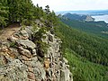
the Kokshetau Lakes, a group that includes lakes Burabay, Ulken Shabakty, Kishi Shabakty, Kopa, Zerendi, Shalkar and Imantau. The lower slopes of some of...
5 KB (466 words) - 00:42, 6 June 2024

434 km2 (1,326 sq mi). The main ones are Burabay, Shchuchye, Ulken Shabakty, Kishi Shabakty and Zhukey located in the Kokshetau Massif in the north. Zerendi...
4 KB (339 words) - 03:51, 7 March 2024

the highest peak of the Kokshetau Hills. It is located near lake Kishi Shabakty, west of Lake Burabay, dominating the skyline of the lake area. Mount Kokshe...
5 KB (407 words) - 13:05, 11 May 2023

the mountains are smooth and the slopes are cut by snow-fed rivers. The Shabakty, Kyrshabakty, Ushbas, Bugun and Asa, are among the rivers having their...
4 KB (276 words) - 16:39, 8 July 2024
located in the northern slopes of the Karatau Range by the right bank of the Shabakty river, south of its confluence with the Kyrshabakty, its main tributary...
3 KB (142 words) - 11:23, 28 October 2022
town had a population of 5864. The town is located by the banks of the Shabakty river to the southeast of the Akzhar lakes, 25 kilometers (16 mi) northeast...
5 KB (192 words) - 21:46, 18 January 2024
part of the Cambrian Period. Fossils of the genus have been found in the Shabakty Formation of Kazakhstan. Sepkoski, Jack (2002). "A compendium of fossil...
1 KB (80 words) - 14:54, 6 January 2024
Formation Cretaceous Kugaly Formation Permian Kurgan Formation Ediacaran Kyr-Shabakty Formation Cambrian Kyzyltal Suite Jurassic Malokaroyskaya Group/Chichkanskaya...
6 KB (30 words) - 18:21, 20 February 2023

river reaches the northern end from the east and sinks in the sands. The Shabakty river has its mouth in the southern part of the lake area, but its waters...
4 KB (344 words) - 15:05, 22 January 2023
by the banks of the Burkittі (Бүркітті) river, a left tributary of the Shabakty. Saudakent village is located 25 kilometers (16 mi) to the northeast. Janatas...
5 KB (258 words) - 20:06, 27 February 2023

Қыршабақты) is a river in southern Kazakhstan. It is a right tributary of the Shabakty, with a length of 95 km (59 mi) and a drainage basin of 805 km2 (311 sq mi)...
3 KB (193 words) - 17:25, 28 March 2024

Shchuchye lies in the eastern sector of the Kokshetau Lakes, SSE of lake Kishi Shabakty and SSW of Lake Burabay. It is the deepest lake of the whole group. Its...
3 KB (266 words) - 03:52, 7 March 2024

northwards, parallel to the Burkittі (Бүркітті), a left tributary of the Shabakty river, to the east. Finally it ends up in the southeastern shore of Kyzylkol...
3 KB (196 words) - 17:15, 28 March 2024